
You do not need a full day and a set of crampons to stand on top of an Irish mountain and see three counties. Some of the best summit views in the country sit at the end of a boardwalk, a 20-minute pull from a car park, or a 300m hill you can climb before lunch. The nine below are ranked by what you get back for the effort you put in, and they run roughly from easiest to hardest. The first four ask very little and give a lot. The last two are proper hillwalking and want a clear day, a map and legs that have done it before. There is one honest catch worth flagging up front: several of these have no marked path near the top, and Irish cloud drops fast, so read the caveat under each before you set off.
1. Killiney Hill, County Dublin
Killiney Hill gives you one of the best views near Dublin for about 20 minutes’ effort, which is the whole reason it opens this list. From the 153m summit you look north over the city and Dublin Bay to Howth, south to Bray Head and the Wicklow Mountains, and east across the Irish Sea to the mountains of Wales on a genuinely clear day. It is the lower of the twin hills above Dalkey, the centre of a free park open dawn to dusk, and a paved path runs to the top that is manageable for wheelchairs.

The obelisk on top is not decorative. John Mapas put it up in June 1742 as famine-relief work during the winter Irish remembers as Bliain an Áir, ‘the year of the slaughter’, and the many old walls across the hilltop were built for the same reason, to give the destitute paid work. If you only do one thing, walk straight up to it from the Burton Road car park and back. Getting here is easiest by DART: it is a 10 to 15 minute walk up from Dalkey station. The free car park on Burton Road and the pay-and-display at the main entrance both fill fast on sunny weekends, so come before 10am or take the train. The summit is fully exposed, so bring a windproof layer even in July.
2. Croghan Hill, County Offaly
Croghan Hill is an extinct volcano that erupted around 300 million years ago, and it rises so abruptly from the flat Bog of Allen that a 232m hill dominates the whole midland skyline. The walk is short and honest: a signposted 1.8km loop from the Croghan Community Centre, about 20 minutes up and a similar time down, graded moderate because the incline is steep in sections even though the distance is small. From the trig point the flat horizon opens a genuine 360-degree panorama, with the Slieve Bloom Mountains to the south, the Wicklow Mountains to the east, and the Mount Lucas wind farm turning to the north-east.

The layers of history are what make this more than a leg-stretch. The unexcavated summit mound dates to the Bronze Age, two holy wells sit on the slopes, and the hill is internationally known for Old Croghan Man, the exceptionally preserved Iron Age bog body found nearby in 2003, whose remains are now in the National Museum in Dublin. Partway up, a wooden stile leads into an ancient graveyard with a high cross among the headstones. Free parking is at the community centre. Wear shoes with grip, because the path is uneven and turns muddy when wet, and time it for late afternoon to catch the sun dipping behind the Slieve Blooms.
3. Diamond Hill, County Galway
A boardwalk and stone path run most of the way up Diamond Hill, which is why a 442m mountain with a real summit view ends up busier than almost any hill in Connemara. It is reckoned the second most-walked trail in Ireland after Croagh Patrick. Do not be put off by the word ‘hill’: this is a proper little mountain of pale quartzite in Connemara National Park, and the path exists because the old routes eroded so badly the mountain was closed from 2002 to 2005 and reopened with the boardwalk you walk on now. The Irish name, Binn Ghuaire, remembers Guaire Aidne mac Colmáin, a 7th-century King of Connacht.
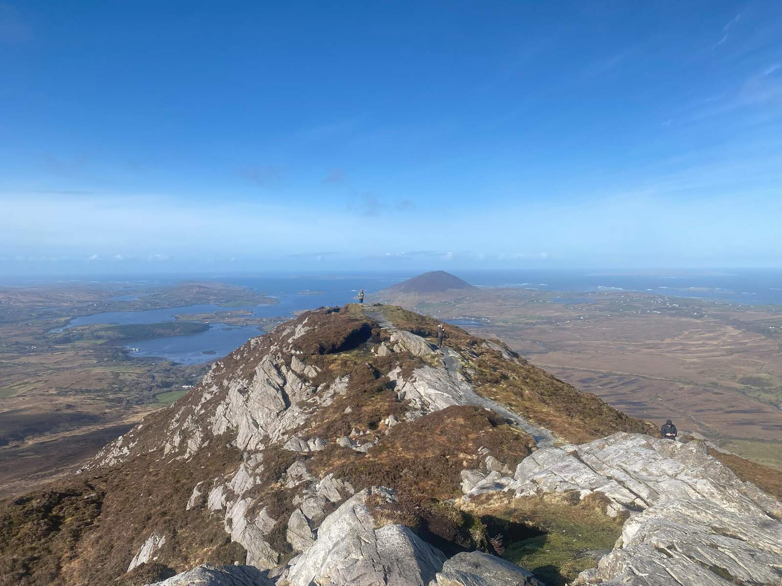
The one worth doing is the full upper loop to the summit, about 7km and two and a half hours, graded strenuous, with a stony quartzite ridge near the top that needs decent footwear and a steady head. From there you get Kylemore Abbey and Kylemore Lough below, the wall of the Twelve Bens east, and out west the Atlantic carrying Inishbofin and Inishturk. The honest caveat is ‘on a clear day’: Connemara weather turns fast and plenty of walkers reach the top to find the view packed away in cloud, so keep the lower 2.8km loop as a fallback. Everything starts at the free Visitor Centre, off the N59 near Letterfrack. Parking is small and fills early, so get there before 10am.
4. Djouce Mountain, County Wicklow
Djouce Mountain rises to 725m on the north-eastern edge of the Wicklow Mountains, and its OPW boardwalk makes it one of the most accessible high summits in Ireland, a short drive from Roundwood and well within a day trip from Dublin. The boardwalk is a rare piece of Irish hillwalking infrastructure, lifting you above the fragile peat on a dry, stable route in most conditions. The most popular way up starts from the J.B. Malone car park off the R759, climbs steadily along the planks past the memorial stone, then leaves them for a well-worn gravel path to the summit. The round trip covers roughly 6 to 7km and takes 2 to 3 hours.

The pay-off is the view over Lough Tay, the lake locals call Guinness Lake for its dark water and pale shore, with the granite cliffs of Luggala above it and the line of the Irish Sea beyond. One caveat that matters: the final stretch to the trig point is unmarked and needs basic navigation, and the open upper slopes are exposed and get slippery in wet weather. The J.B. Malone car park is small and fills quickly on sunny weekends, so arrive before 10am, and download an offline map or GPX before you go because mobile signal on the upper slopes is unreliable.
5. Slieve Gullion, County Armagh
Slieve Gullion is the highest point in County Armagh at 573m, and it doubles as two different days out. The eastern slope holds a forest park with a café, a 10km scenic drive and a mile-long story trail for children, so a family can have a full afternoon without climbing at all. The summit above is the serious half: a well-marked 13.5km loop from the Courtyard car park, roughly 3 to 4 hours with 511m of climb, graded a moderate day hike. Local folklore calls this the Mountain of Mystery, and the Cailleach Bhéara is said to dwell in the lake on the top.
The reason to make the climb is on the summit itself: the southern cairn is a Neolithic passage tomb from around 3500 to 2900 BCE, the highest surviving passage grave in Ireland, with a corbelled chamber and stone basins. From the top the volcanic Ring of Gullion opens all around, its circular band of harder rock forming the classic crag-and-tail shape you can pick out from the plains below. Swimming in the summit lake is strictly prohibited, as it is a protected sacred site. Parking is free for the first hour with a modest charge after, and the summit trail is steep and uneven, so keep the boots and waterproofs on the higher route.
6. Slieve Mish, County Kerry
Where the MacGillycuddy’s Reeks bristle with jagged granite, the Slieve Mish range does the opposite: rounded, grassy and walkable from end to end, which is exactly why beginners and families end up here. The range runs 19km along the eastern spine of the Dingle Peninsula, minutes from Tralee, and the walks cover the full spread. The gentle end is the Tonevane Loop, a 2km walk climbing only 94m with wide views of Tralee Bay, the one to pick with children. At the hard end sits the Curraheen Derrymore Loop, a 23km circuit of 7 to 8 hours over Baurtregaum, the range high point at 851m.
The rock is the reason to time your walk for the evening. The range is built mostly of Old Red Sandstone, stained a deep purple-red by iron oxidation that intensifies in late-afternoon sun. Halfway up sits Caherconree, a stone promontory fort 683m up the mountain that legend says the king Cú Roí enchanted to spin on its axis at night so attackers could never find the door. The weather turns fast and the ground includes boggy stretches and cattle paths, so bring waterproof boots and a windproof layer even in summer, and carry the Ordnance Survey Discovery Series Sheet 71 for the summit loops. Arrive in the late afternoon: that is when the ridges go purple and gold.
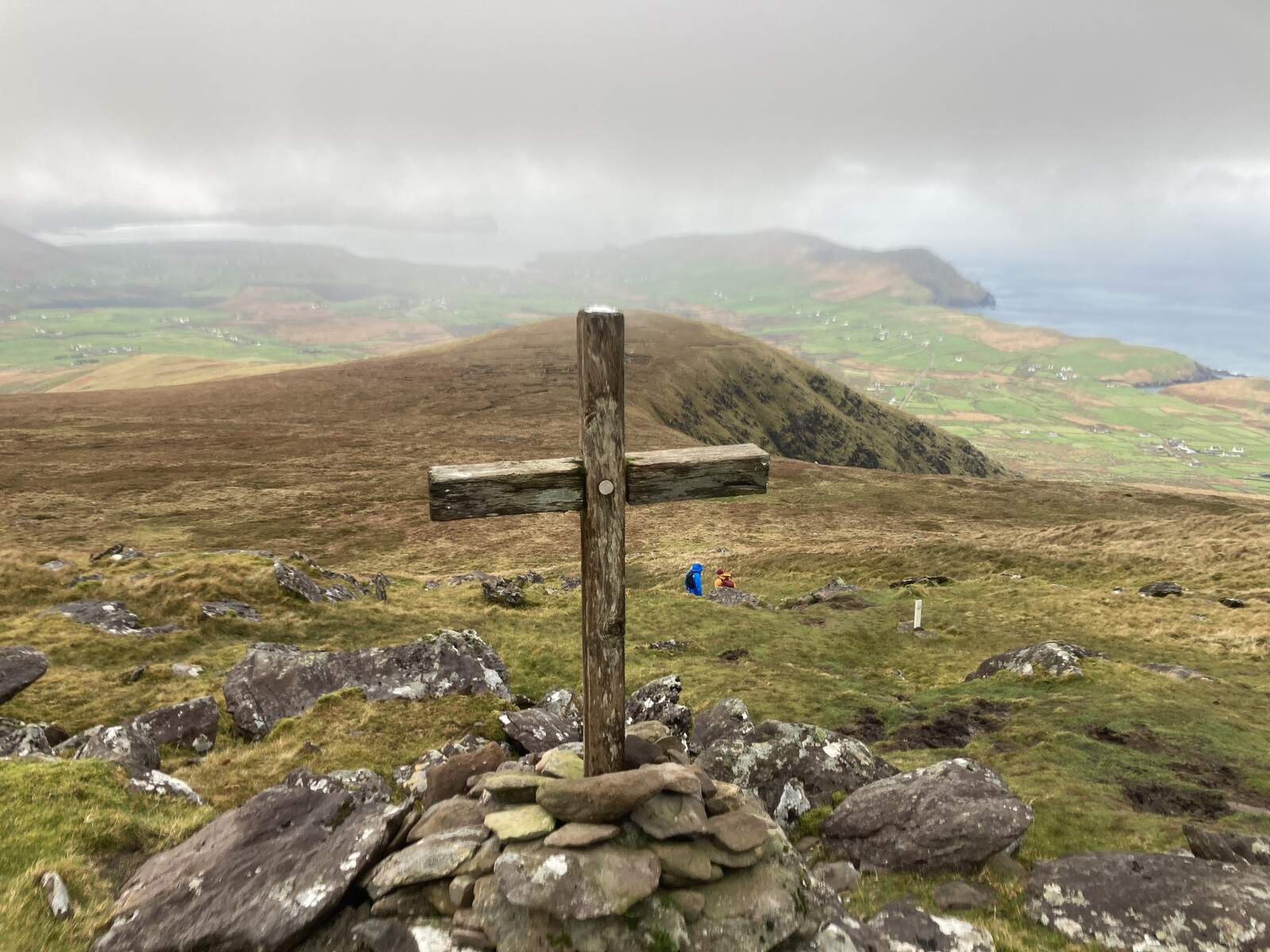
7. Errisbeg Hill, County Galway
Errisbeg Hill rises just 300m straight behind Roundstone, and it earns its place for how much it shows you for so little height. From the summit you look straight down on the twin white-sand crescents of Dog’s Bay and Gurteen, east to the Twelve Bens, and south to the Aran Islands across the Atlantic on a clear day. The 17th-century Connemara historian Roderic O’Flaherty noted it as a sea-mark, the landmark sailors picked out after the Twelve Bens. It is roughly 6km there and back with about 300m of climbing, and most people take three to four hours.
The catch is real and worth stating plainly: there is no path. AllTrails is blunt about it, calling it a hill walk with no distinguishable route where you make your own way. Treat this as proper open-bog navigation, not a stroll. A good line starts from Roundstone harbour, up Fuchsia Lane beside O’Dowd’s to a gate after about 15 minutes, then left and up rough, boggy hillside to the cairn and trig pillar. Phone signal is poor, so download an offline map or bring a paper one and a compass, and do not rely on your phone to find the way down if mist comes in. Save it for a clear day, wear waterproof boots, and dogs are not permitted, as the ground is grazed sheep pasture.
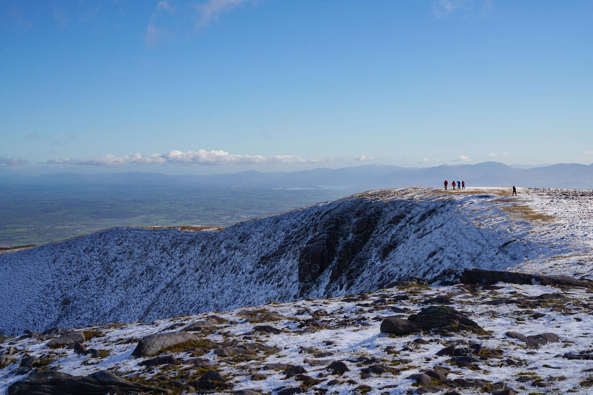
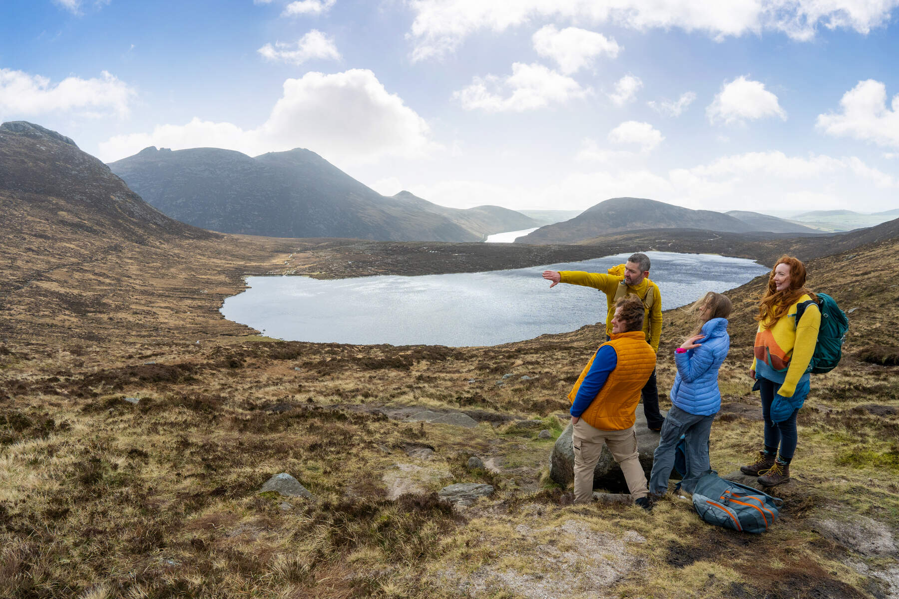
8. Mourne Mountains, County Down
The Mourne Mountains are the granite range that runs roughly nine miles between Newcastle and Rostrevor in County Down, with twelve summits above 2,000ft and Slieve Donard, the highest peak in Ulster, dominating at 850m. This is where the effort ramps up. The classic route is the ascent of Donard by the Glen River, a roughly 9km round trip that follows the water up to the Mourne Wall before the final climb to the summit cairns, and from the top on a clear day the view reaches the Isle of Man, Scotland and the Wicklow Mountains.
The signature of the range is the Mourne Wall, a 35km dry-stone barrier built between 1904 and 1922 that crosses fifteen summits and still stitches the tops together, put up to keep livestock off the Belfast water catchment. If you want the view without the full summit push, the walk to Hare’s Gap from Trassey car park is about 7km and delivers the valley drama with far less commitment. Note this is Northern Ireland, so distances on signs are in miles and money is in pounds. The range takes up to 2,000mm of rain a year, mobile coverage drops on the higher ridges, and winter brings snow and ice to the summits that need crampons and an axe. Carry waterproofs and a physical map, and check the Mourne Mountain Rescue advisory before you leave.
9. Mount Brandon, County Kerry
If you want the biggest mountain day on this list, make it Mount Brandon. At 952m it is Ireland’s eighth-highest peak and the highest outside the MacGillycuddy’s Reeks, a windswept plateau on the Dingle Peninsula where a large iron cross and the ruins of a stone oratory mark the end of one of the country’s oldest pilgrimage routes. The gentlest way up is the Saint’s Route, Cosán na Naomh, a 7km return trail from Baile Breac near Ventry that follows a grassy ascent marked by stone crosses and takes 4 to 5 hours, the most accessible option here but still a serious walk.
The harder approaches are not for beginners. The Faha Grotto route climbs through a glaciated valley past a chain of lakes and the upper section needs careful footing and light scrambling, while the Faha Ridge Traverse involves Grade II scrambling along exposed ridges and is only for experienced walkers with a head for heights. The mountain is named after Saint Brendan the Navigator, who legend says fasted three days on the summit before setting out to sea. Free car parks sit at Baile Breac in the west and near the Faha Grotto in the east, and the Faha lot holds only about ten cars, so arrive early. Carry the OSI Discovery Series 70 map and a compass, because mobile reception is unreliable on the ridges and afternoon cloud frequently obscures the summit.
Whichever you pick, the single most useful habit is to check the Met Éireann forecast the night before and again on the morning, then match the mountain to the sky: on a clear, still day take one of the pathless hills like Errisbeg or the Diamond Hill ridge while the view is out, and when the cloud is down keep it to a boardwalk or a short loop where losing the top matters less.


