
Most of Ireland’s best sea cliffs aren’t fenced, ticketed or even properly signposted. That is the appeal and the catch. The six headlands below run from the 601m face of Slieve League down to the closest mainland view of the Skelligs, and they vary as much in how much they ask of you as in what they show you. Some you can see from a car park; one needs a 40-minute walk over bog with no marked path. If you only have time for one and you want the single biggest drop, make it the first. If you want a clifftop largely to yourself, skip to number four.
1. Slieve League, County Donegal
Slieve League rises 601m (1,972 ft) straight out of the Atlantic in south-west Donegal, which makes it the second-highest sea cliff in Ireland and nearly three times the height of the Cliffs of Moher. The Irish name, Sliabh Liag, means ‘mountain of the precipice’, and the figure is the reason to start here: nothing else on this list comes close to the scale. From the Bunglass platform the drop falls to a white-sand beach you can only reach by boat, with seals often working the water near the sea-cave below and the Sligo mountains across Donegal Bay.

There is more here than the view. Early Christian monks left beehive huts on the summit, a Napoleonic signal tower stands on the lower slopes, and a stone ‘ÉIRE’ sign from the Second World War marks the neutral airspace below. The hard option is One Man’s Pass, the knife-edge ridge that links the Pilgrim’s Path to the summit with a 550m drop on the ocean side. Praeger walked it in 1939 and rated it one of the most remarkable walks in the country, but it is strictly for experienced hikers and never in wet, windy or low cloud. Reach the cliffs on the R263 from Killybegs to Teelin. The lower car park is €5 for three hours and leaves you a 30-minute uphill walk; a summer shuttle runs to the upper car park for €6. On a windy day, stay well back from the edge – the upper trails turn treacherous in minutes.
2. Mizen Head, County Cork
If Malin Head is the top of the country, Mizen Head is the bottom corner: the most south-westerly tip of the mainland, on the Mizen Peninsula in County Cork. The signature is the arched bridge, 50m in span, rising roughly 45m above the sea and carrying you across to the old signal station on Cloghane Island. You reach it down the 99 Steps from the visitor centre, about a 15-minute descent, with the Beara Peninsula and Fastnet Rock and its lighthouse in view along the way.
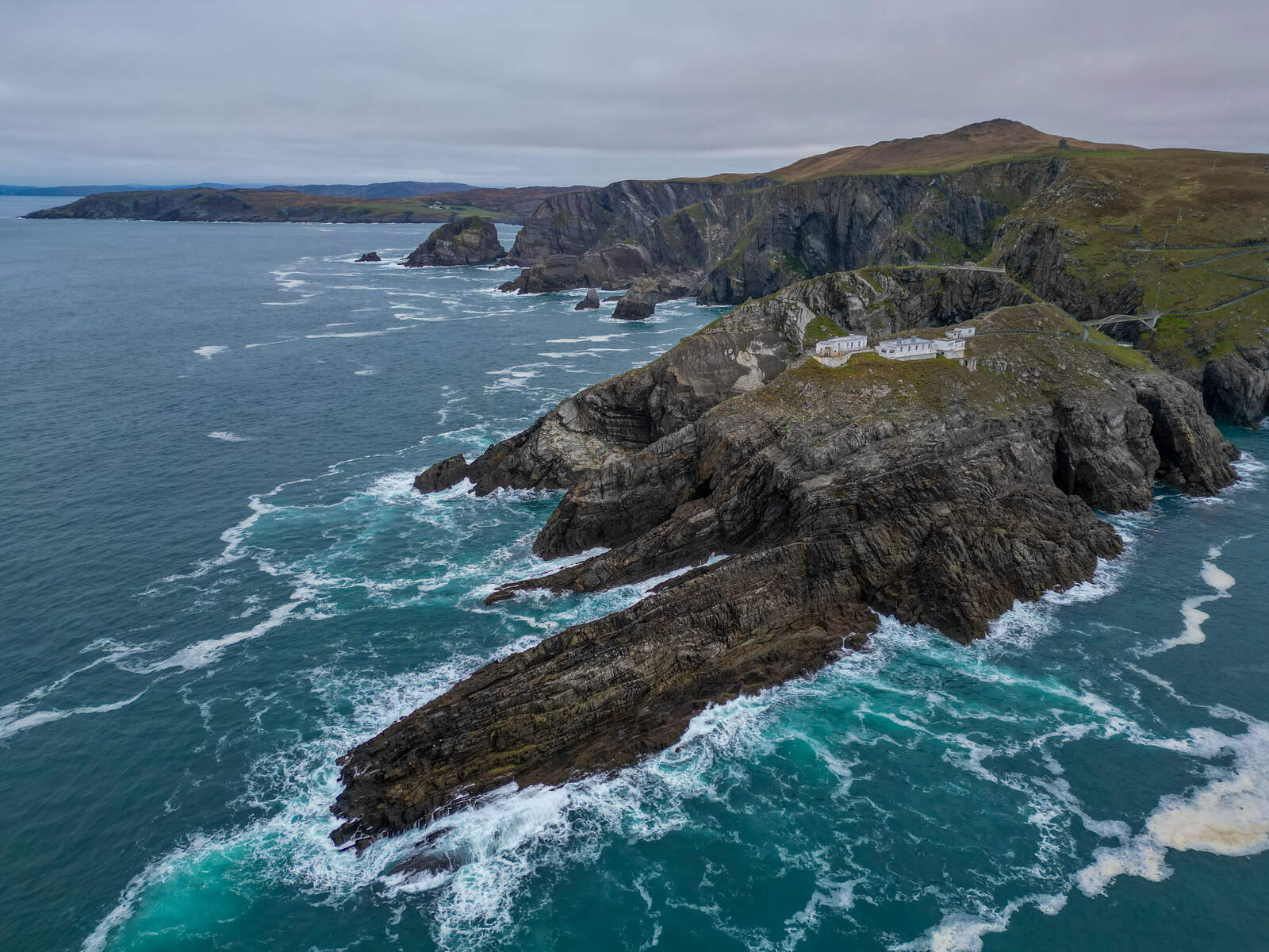
This is the most worked-up site on the list, and that is partly the point. A fog-signal station opened here on 3 May 1909 and Ireland’s first radio beacon followed in 1931, the last home view for many emigrants crossing the Atlantic. The keeper’s quarters, engine room and Marconi radio room survive as the on-site museum, and a €500,000 refurbishment in 2024 added a double-height café. Seals haul out on the rocks under the span, and gannets, kittiwakes and choughs work the cliffs. Adult admission is €7.50, with a family ticket at €25, and parking is free in a large car park. Two practical notes: the coastal paths close at 16.30 in July and August even though the centre stays open later, and the cliff paths are steep enough to need proper footwear.
3. Kerry Cliffs, County Kerry
The Kerry Cliffs rise 305m (1,000 ft) above the Atlantic just outside the fishing village of Portmagee, on the Skellig Ring, and they earn their place for one reason: this is the closest mainland vantage point to Skellig Michael, Little Skellig and Puffin Island. On a clear day the view runs about 30 miles across coast and open ocean. The rock is 400-million-year-old Old Red Sandstone, and the iron oxide in it gives the cliff a red and purple cast that deepens in the low light of early morning and late afternoon.

This is the most managed cliff on the list, and whether that is a plus depends on what you want. The main platform sits at the end of a wide gravel path with barriers and seating; a northern trail leads to a wilder spot where the waves break against the cliff base, best at high tide. There is a glass-fronted café, on-site camping with toilets open around the clock, and a small herd of alpacas, donkeys and horses for anyone travelling with children. Admission is €5 per adult, paid at a booth in the car park. Allow at least an hour, and come in the couple of hours before sunset for the best light on the Skelligs and the warmest colour in the sandstone.
4. Horn Head, County Donegal
Horn Head is the one locals quietly rate above Slieve League, and not for its height. The quartzite cliffs rise about 180m straight from the Atlantic at the mouth of Sheephaven Bay, just north of Dunfanaghy, and the trade for the lower drop is that on most days you will have the headland to yourself and the seabirds. It is barely signposted. National Geographic, which once named Donegal the coolest place on the planet, called Horn Head a loop that squeezes the whole Wild Atlantic Way into a few miles.

If you do one thing here, drive out to the Lookout Point and walk the last 30 to 40 minutes towards the World War II signal tower. From there the sweep takes in Tory Island to the north-west, Bloody Foreland to the west, Malin Head away east, and Errigal and Muckish inland. Look near the tower for the white ‘77 EIRE’ lettering laid into the rocks, one of dozens of such wartime markers around the coast. Now the honest warnings, because this is the least forgiving spot on the list. The access road from Dunfanaghy is single-track, twisting and roughly 4km with nowhere to turn, so take it slowly and pull in for oncoming cars. Past the car park there is no marked trail, the ground is rough and boggy, and the place is genuinely dangerous in mist if you can’t navigate. Save it for a clear day and keep well back from the open, unprotected edges. McSwyne’s Gun, the old blow-hole on the west side, once forced spray 60 to 90m into the air, but erosion has tamed it and most who come for the spectacle leave disappointed.
5. Malin Head, County Donegal
Stand at Malin Head and there is no more mainland Ireland north of you. At the tip of the Inishowen Peninsula, this is the country’s northernmost point and the official start of the Wild Atlantic Way, marked by the stone Lloyds Signal Tower on Banba’s Crown. The history under your feet is unusually dense: in 1902 Marconi sent the first commercial radio message from Ireland here, to the steamship S.S. Lake Ontario, the same station later helped relay the Titanic distress calls, and a weather station on the headland still feeds the BBC Shipping Forecast.
A level loop of about 2.5km from the car park takes roughly an hour and links the signal tower, the restored ‘EIRE 80’ wartime marker, and Hell’s Hole, a 250-foot sea cave where the tide surges through a narrow gap. Watch the offshore water for bottlenose dolphins, basking sharks and the occasional minke whale, and in winter the dark skies here are good for the Northern Lights. The trail is level but fully exposed to the Atlantic wind, so bring a windproof jacket, and check the tide times before you go near Hell’s Hole. (There is no member image for this headland.)
6. Bunglass Point, County Donegal
Bunglass Point is the viewing platform for the Slieve League cliffs rather than a separate cliff of its own, which is why it sits last: see it as the best seat for number one, not a seventh wonder. It is the eastern edge of the same cliff complex, the quieter perch that photographers prefer, where the plateau breaks off and drops sheer to the water and you get the serrated skyline of cliff faces with far fewer people in the frame than the main centre pulls.
Two layers of history sit on the headland. A small British watchtower built around 1804 still crowns the point, put there to watch for French invasion fleets, and two stone slabs spelling ‘Éire’ were laid along the edge during the Second World War. A marked 1.5km trail climbs steadily from the lower car park to the platform, 30 to 45 minutes over uneven, rocky ground that gets slippery when wet, and parking is free all year. If you drive the upper road, a metal gate near the end is only there to keep sheep off the tarmac, so open it, drive through and close it behind you. Come early: the morning light catches the cliff faces before the midday haze, and you will get a space. Stay behind the railings, because Atlantic fog can drop visibility to near zero in minutes.
One rule for all six
These cliffs are largely unmanaged, and that is the deal you accept by coming. The wind is the real hazard, not the height: a gust can knock you off balance on an open edge, so treat any exposed ridge with caution and leave the upper trails alone on stormy days. Check the Met Éireann forecast before you set out, wear boots that cope with wet bog, and keep children and dogs close on a lead. If you want the easiest day with the biggest payoff, pair Bunglass Point with Slieve League on a calm, clear morning and let the harder headlands wait for the next dry spell.


