Overview
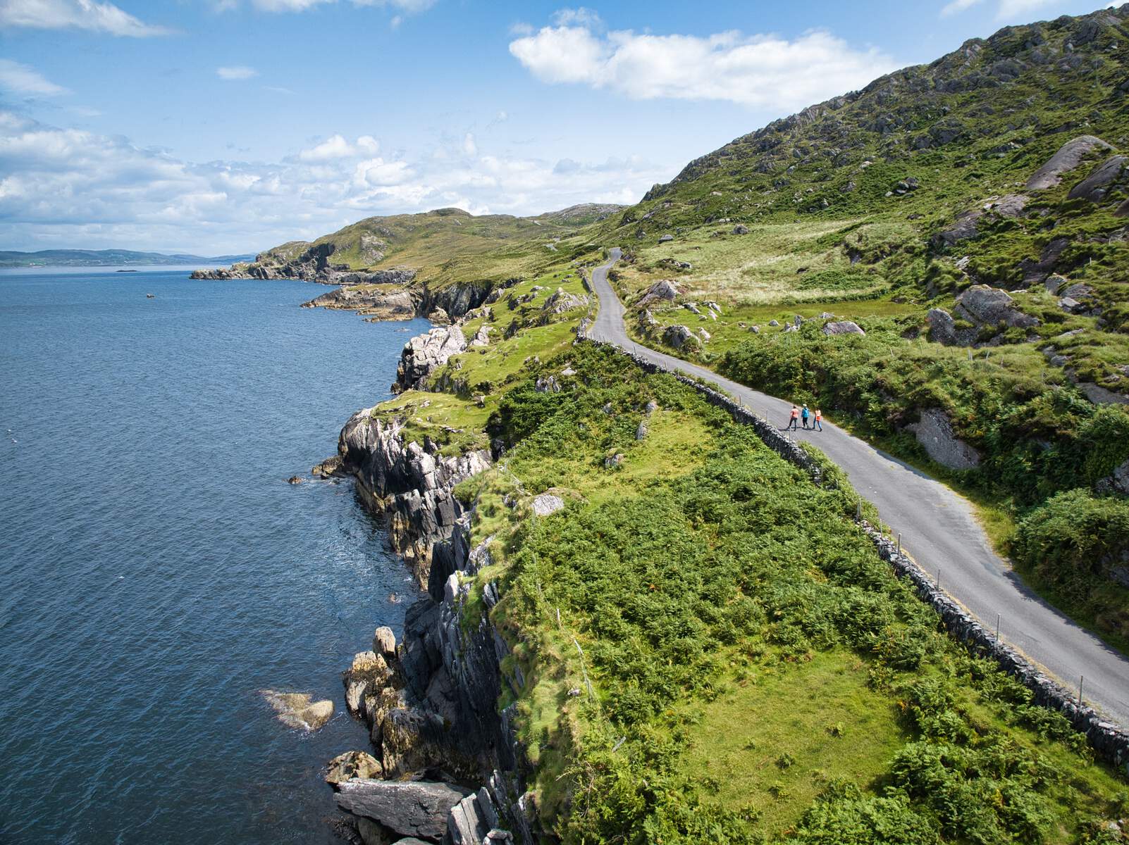
The Beara Way is a strenuous, 241.8 km (150 mi) loop that starts and finishes in the picturesque harbour town of Glengarriff in County Cork. It traverses the rugged spine of the Beara Peninsula – the Caha and Miskish mountains – before skirting the Atlantic coastline, slipping onto islands and passing through a string of colourful villages such as Adrigole, Castletownbere, Allihies, Eyeries, Ardgroom, Tuosist and Bonane. The trail is marked by a yellow arrow on a black background and is managed by the Beara Tourism and Development Association. With a total ascent of 5,245 m, the route is typically completed in nine days, though walkers can break it into shorter stages or enjoy the many looped sections.
| Trail statistic | Detail |
|---|---|
| Length | 241.8 km |
| Typical duration | 9 days |
| Grade | Strenuous |
| Ascent | 5,245 m |
| Dogs allowed | No |
| Waymark | Yellow arrow on black |
| Start / Finish | Glengarriff (Lat 51.74982, Lon ‑9.55246) |
The Beara Way forms part of the Beara‑Breifne Way and the European E8 long‑distance route, linking the peninsula to a network that stretches from Dursey Island to Istanbul.
History
Planning for the Beara Way began in 1991 when the Beara Tourism and Development Association secured funding from the West Cork County Development Team, Cospóir and Bord Fáilte. Construction was carried out by workers on FÁS social‑employment schemes. The trail was officially opened by Minister of State Toddy O’Sullivan in June 1996. A major upgrade in 2009 added 20 new bridges, 200 stiles, 15 information boards and 30 plaques, dramatically improving safety and wayfinding. A 2010 review highlighted the Beara Way as one of the most heavily used National Waymarked Trails and recommended its promotion to the new National Long Distance Trail standard.
What to See & Do
Mountain scenery and coastal drama
The route climbs into the Caha Mountains, passing the Sugarloaf and offering sweeping views over Glengarriff Harbour and the Wild Atlantic Way. Further east, the trail skirts the southern flanks of Hungry Hill and the Slieve Mish range, delivering dramatic sea‑to‑mountain panoramas.
Historic islands and forts
A spur loop takes walkers onto Bere Island, reachable by a frequent 10‑minute ferry from Castletownbere. The island is dotted with 19th‑century military forts that guard the harbour. Another spur leads to Dursey Island, accessed via Ireland’s only cable‑car – a unique experience that drops you onto the western tip of the peninsula for spectacular cliff‑top walks.
Mining heritage and archaeology
The village of Allihies was once a bustling copper‑mining centre; remnants of abandoned shafts and a small mining museum testify to this industrial past. Throughout the peninsula, Bronze Age stone circles, wedge tombs and standing stones pepper the landscape, especially near Lauragh and Kealkill.
Charming villages and local culture
Each settlement along the Way has its own character. Eyeries is a Tidy Towns award‑winner with brightly painted cottages and a thriving arts scene. Castletownbere remains Ireland’s largest white‑fish fleet port, while Adrigole offers a quiet harbour and the Hungry Hill Hostel for walkers. Ardgroom and Lauragh provide cosy B&Bs and cafés that serve fresh Atlantic seafood.
Links to other long‑distance routes
The Beara Way intersects the Mealagh Valley Walking Route (connecting to the Sheep’s Head Way) and forms the start/end of the Beara‑Breifne Way, which follows the historic march of Donal Cam O’Sullivan Beare after the Battle of Kinsale (1602). Cyclists can also enjoy the Beara Way Cycling Route, a 165 km loop of quiet country roads.
Practical Information
The trail is loop‑shaped, so walkers can begin at any stage, though most choose Glengarriff because of its good transport links and range of accommodation. Public transport is limited – an express bus service (check with Bus Éireann) runs to Glengarriff, and a similar service operates from the finish point. For those tackling the full circuit, luggage transfer and packed‑lunch services are offered by many B&Bs along the route, easing the burden of heavy packs.
Accommodation is generally plentiful, ranging from hostels (e.g., Hungry Hill Hostel in Adrigole) to family‑run B&Bs and hotels in Castletownbere, Allihies, Eyeries, Ardgroom, Lauragh and Bonane. Because some sections – notably the stretch between Ardgroom and Lauragh – can be boggy, walkers often plan a night in Lauragh or Mourlin Lodge to break up the distance.
Ferry and cable‑car services are seasonal. The Bere Island ferry runs multiple times daily during the summer months. The Dursey Island cable‑car operates in the summer but may be temporarily out of service for maintenance (as reported by walkers in 2016). Checking the latest timetable on the Beara Tourism website before setting out is advisable.
Waymarking is reliable on the Cork side of the peninsula; the Kerry side has a few gaps, especially between Lauragh and Kenmare, where walkers should keep an eye on the yellow arrows and carry a recent Beara Way map (available as PDFs on the Sport Ireland page or via the ActiveME app). The 2009 upgrades mean most river crossings are bridged, but a few stiles and boardwalks remain, so sturdy walking boots are recommended.
Navigation aids: detailed stage maps are downloadable from Sport Ireland (e.g., Overview Map and the series of BEW – Map 1‑15 PDFs). The ActiveME mobile app provides GPS tracks and offline maps, useful for sections where the trail briefly follows quiet roads.
Safety notes: while the trail is well‑signposted, occasional mis‑directed signs have been reported near Kenmare and Bunane. Walkers should be prepared for boggy ground on the Ardgroom‑Lauragh stretch and for steep climbs on the Hungry Hill and Knockagarrane sections. The trail is not dog‑friendly, and there are no entry fees – it is free to walk.
Getting there: Glengarriff is reachable by car via the N71 from Cork or Killarney. Parking is available at the trailhead and in the village centre. For those arriving by public transport, the nearest railway stations are Killarney (County Kerry) and Cork City, with onward bus connections to Glengarriff.
Further resources:
- Official Beara Tourism contact: Tel 027‑70054, email bearatourism1@gmail.com
- Trail overview and downloadable maps: Sport Ireland – Beara Way
- Stage‑by‑stage guides (including distances and elevation): the ActiveME website hosts individual pages for each stage (e.g., Stage 1 – Glengarriff to Adrigole).
- Cycling information: Discover Ireland – Beara Way Cycling Route
Whether you are a seasoned hill‑walker seeking a multi‑day challenge, a history enthusiast eager to explore copper‑mining relics, or a coastal lover craving Atlantic vistas, the Beara Way delivers a richly varied experience that showcases the very best of Ireland’s southwest.