Overview
Carrickfad – An Charraig Fhada in Irish – is a small townland situated in the electoral division of Sramore, within the civil parish of Drumlease, barony of Drumahaire, County Leitrim. It lies at 54° 16′ 52″ N, 8° 20′ 7″ W, making it one of the 226 largest townlands in Leitrim and the 14 781 st largest in the Republic of Ireland. Though the townland itself is largely agricultural and residential, the name Carrickfad also appears on the Atlantic coast of County Donegal, where a dramatic rock outcrop marks the western limit of the blue‑flagged Rossnowlagh Beach.
History & Background
The Irish name An Charraig Fhada translates directly as “the long rock”, a description that fits both the inland stone features of the Leitrim townland and the coastal outcrop that juts into the sea at Rossnowlagh. Historical records for Carrickfad are primarily genealogical; the townland is listed on the Logainm.ie placename database and appears in the 19th‑century Ordnance Survey maps of Leitrim. While detailed events are scarce, the area’s inclusion in the Drumahaire barony ties it to the ancient Gaelic territories that once dominated the north‑west of Ireland. For family historians, the townland offers a gateway to census returns, land valuations and parish registers that can illuminate the lives of former residents.
What to See & Do
Inland Exploration
- Walk the Countryside – The gently rolling fields and hedgerows of Carrickfad provide an ideal setting for leisurely walks. Bird‑watchers may spot skylarks, meadow pipits and, on a lucky day, the occasional hen harrier.
- Genealogy Research – The townland’s inclusion in the Drumlease parish records means that local archives and the Leitrim County Library can be valuable resources for tracing family roots.
Coastal Connection – The Carrickfad Rock Outcrop
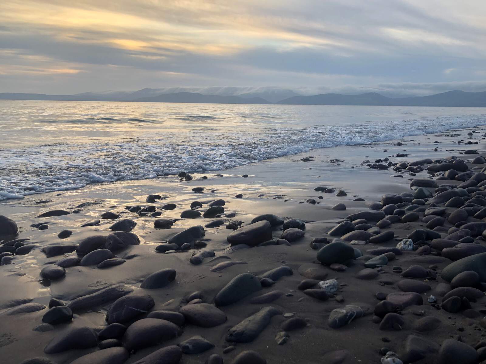
The most striking visual link to Carrickfad is the rock outcrop that defines the western edge of Rossnowlagh Beach in County Donegal. Rossnowlagh is celebrated as one of Ireland’s premier surfing beaches, stretching from the cliffs at Coolmore to the Carrickfad outcrop. The beach’s soft golden sand, blue‑flag status and consistent surf make it a magnet for beginners and seasoned riders alike. The outcrop itself offers a dramatic viewpoint over the Atlantic, perfect for photography and quiet contemplation.
- Surfing – Local surf schools provide tuition and equipment hire, with waves that can reach up to six metres in winter.
- Beach Wheelchair Access – Rossnowlagh is one of the few Donegal beaches equipped with free‑hire beach wheelchairs. Visitors can arrange a wheelchair in advance through the Sandhouse Hotel & Marine Spa (info@sandhouse.ie).
- Smugglers Creek Inn – At the foot of the outcrop, this historic inn offers a cosy spot to enjoy a meal while watching the surf roll in.
Wildlife & Birdwatching
The mix of farmland, river valleys and coastal cliffs creates a varied habitat for wildlife. In addition to the skylarks and meadow pipits mentioned above, spring brings passage of migratory waders such as oystercatchers and curlews along the Rossnowlagh shoreline. The inland fields are also a good place to spot hares and, occasionally, red foxes.
Practical Information
| Item | Details |
|---|---|
| Coordinates (Townland) | 54° 16′ 52″ N, 8° 20′ 7″ W |
| Nearest Town | Drumshanbo, Co Leitrim (≈ 10 km) |
| Access by Road | The R208 and local L‑roads connect Carrickfad to the N4 corridor. |
| Public Transport | Bus Éireann routes serve Drumshanbo; a taxi from there can reach the townland in 15 minutes. |
| Parking | Free roadside parking is available on the minor roads surrounding the townland. |
| Beach Wheelchair Booking | Email info@sandhouse.ie (Rossnowlagh, Donegal) – advance reservation recommended during peak summer months. |
| Website | – |
Getting There
Travelers arriving by car from Dublin can take the M4 westward, joining the N4 at Kinnegad and continuing to the R208 towards Drumshanbo. From Drumshanbo, follow the local signs to the Carrickfad townland. For the coastal outcrop, head north from Donegal town on the N15, then follow the R263 to Rossnowlagh; the rock outcrop is visible from the main beach promenade.
Seasonal Highlights
- Surf Season – While surf schools operate year‑round, the most reliable swells arrive from late autumn to early spring, attracting experienced riders seeking larger waves.
- Summer – June‑August sees the highest visitor numbers on Rossnowlagh, with surf lessons, beach cafés and the wheelchair service in full demand.
- Bird Migration – Spring (April‑May) and autumn (September‑October) are prime times for birdwatchers, as migratory waders pass the coastline.
Nearby Attractions
A short drive from Carrickfad opens up several of Leitrim’s highlights:
- Creevelea Abbey – Ruins of a 16th‑century Franciscan friary near Dromahair. Great for a historic walk. (Creevelea Abbey)
- Glencar Waterfall – A 15‑metre cascade set in a wooded gorge, reachable via a short hike. (Glencar Waterfall)
- Lough Allen Adventure – Water‑sports, fishing and scenic walks on the shores of Lough Allen, based in Drumshanbo. (Lough Allen Adventure)
- Leitrim Village Trail Map – Handy for planning walks across the county’s network of trails. (Trail Map)
Why Visit Carrickfad?
Carrickfad offers a rare juxtaposition: a peaceful, historically rich inland townland in Leitrim and a namesake coastal landmark that frames one of Ireland’s most celebrated surf beaches. Whether you are tracing ancestry, enjoying a quiet countryside stroll, or chasing the perfect wave at Rossnowlagh, the “long rock” invites you to experience both the quiet heartland and the wild Atlantic edge of the island.