Overview
Garraun (Irish: Maolchnoc, “bald hill”) is a 598 m (1,962 ft) mountain with a prominence of 553 m, classed as both a Marilyn and an Arderin. It sits on an isolated massif at the mouth of Killary Harbour, Ireland’s largest fjord, forming the heart of the Twelve Bens/Garraun Complex Special Area of Conservation (SAC) within Connemara National Park.
| Property | Value |
|---|---|
| Elevation | 598 m (1,962 ft) |
| Prominence | 553 m |
| Classification | Marilyn, Arderin |
| Grid Reference | L76708 61036 |
| OS Map | OSi50: 037 |
| Coordinates | 53.584702 N, 9.862664 W |
| Irish ranking | 224th‑highest on the Arderin scale |
| Galway ranking | 3rd in prominence |
From its broad, featureless plateau the summit offers uninterrupted vistas of the Atlantic Ocean, the Islands of the West, Killary Harbour, and the iconic Kylemore Abbey and Kylemore Lough on its southern flank.
History & Background
The name Garraun is thought to stem from the Irish garrán (grove) or more evocatively gearrán (fang), a nod to the sharp eastern ridge that drops toward Lough Fee. Local tradition also records the older name maolchnoc – “bald hill” – describing the summit’s smooth surface.
A colourful legend links the mountain to the hero Fionn Mac Cumhaill. According to the tale, Fionn’s dog Bran chased a doe up the slopes; the doe leapt from the cliffs into a lake below, and Bran fell to his death. The nearby townland name Lemnaheltia (“the doe’s leap”) preserves this story.
Half‑way up the south face of the neighbouring Doughruagh peak stands a Sacred Heart statue, erected in 1932 by the Benedictine nuns of Kylemore Abbey as a thank‑you for their safe escape during World War I. Scattered stone cairns across the ridges are remnants of ancient way‑marking.
The Garraun massif lies within the Twelve Bens/Garraun Complex SAC (site code 002031), protecting a mosaic of habitats: alpine and boreal heaths, siliceous scree, calcareous rocky slopes, blanket bogs, and oligotrophic lakes. Notable species recorded in the SAC include the freshwater pearl mussel (Margaritifera margaritifera), Atlantic salmon, otter, and the slender naiad (Najas flexilis).
Ecology & Conservation
The SAC is a key component of Ireland’s Natura 2000 network. Its upland blanket‑bog and heath support nationally important bird populations, notably the Greenland White‑fronted Goose and the Golden Plover. Small patches of old oak woodland – rare in Connemara – add further biodiversity value.
Invasive Rhododendron ponticum has been identified as a threat to native flora and woodland regeneration. The Department of Housing, Local Government and Heritage published a 2024 determination outlining control measures to protect the site’s ecological integrity.
Recent Developments & Community Projects
-
Park expansion (2025) – The National Parks and Wildlife Service purchased 615 acres (≈249 ha) of land within the Twelve Bens/Garraun Complex, increasing Connemara National Park by over 12 %. The acquisition secures additional blanket‑bog, scree and acid‑grassland habitats for visitors and wildlife.
-
Peatland community funding (2023) – €40 000 was awarded to Forum Connemara CLG to restore native flora across the SAC, while €28 000 went to the Connemara‑based Telework Co‑Op Society to maintain a boardwalk at Lettergesh Beach and develop educational tours on peatland and wetland conservation.
-
Coillte planning refusal (2024) – A proposal to plant native woodland and re‑wet peatland within the Garraun Complex was rejected by Galway County Council on the grounds that it could adversely affect the SAC’s integrity. The decision underscores the area’s high protection status.
What to See & Do
Summit Walks
- Direct ascent – From the roofed Creeragh Church car‑park off the N59, a sharp east spur leads to the summit in a 5 km round‑trip (≈2½ h). The route rewards walkers with sweeping views over Killary Harbour, Kylemore Lough and the surrounding peaks.
Lettergesh Loop / Benchoona Horseshoe
- A 9 km circuit (≈4 h) starts at the Lettergesh Beach car‑park (grid L737 630). The loop climbs Cloonagh, arcs around Benchoona, reaches Garraun and its south‑west top Altnagaighera (renowned for striking conglomerate tors), before returning via Cloonagh. This route showcases the rugged tors and the sweeping slopes of Garraun South‑West.
Doughruagh Ridge
- For a longer day, combine Garraun with the double‑top summit of Doughruagh (the “black stack”). The ridge walk passes the Sacred Heart statue and offers dramatic photographic opportunities of Kylemore Abbey reflected in its lake.
Nearby Peaks
- Hikers can extend their trek to Benbaun, the highest of the Twelve Bens, via a connecting ridge that offers additional alpine scenery.
Cultural Highlights
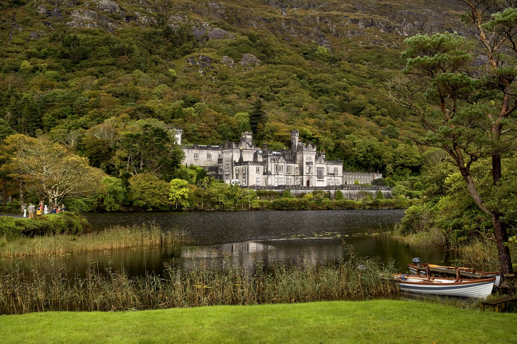
- The Sacred Heart statue and the historic Kylemore Abbey dominate the southern landscape, inspiring countless paintings and photographs.
- Ancient stone cairns provide a tangible link to the mountain’s long‑standing role as a waypoint for travellers.
Wildlife Spotting
- The SAC’s diverse habitats attract otters along the streams, seasonal salmon runs, and a wealth of alpine flora. Early summer is ideal for spotting the slender naiad in the clear waters of Lough Fee. Birdwatchers should keep an eye out for Greenland White‑fronted Goose, Golden Plover, and other wintering waterbirds that use the blanket‑bog and heath.
Practical Information
- Access points: Creeragh Church car‑park (N59) for the direct route; Lettergesh Beach car‑park (grid L737 630) for the loop.
- Parking: Small lay‑by spaces are available at both car‑parks; arrive early in peak season (May–September) to secure a spot.
- Maps & Navigation: Use OSi50 map 037; the grid references L76708 61036 (summit) and L737 630 (Lettergesh Loop start) are essential.
- Difficulty: Moderate – well‑marked paths but steep sections on the eastern ridge; sturdy walking boots and waterproof clothing are recommended.
- Best season: Late spring to early autumn for clear views and active wildlife; winter walks are possible but require winter‑mountaineering gear.
- Safety: Weather can change rapidly on the exposed plateau; carry a map, compass, and a fully charged phone. Notify someone of your intended route if walking alone.
- Facilities: A boardwalk maintained by the Telework Co‑Op Society at Lettergesh Beach provides easier access across wet sections and serves as a starting point for educational tours.
Garraun’s blend of striking geology, mythic history and protected wildlife makes it a rewarding destination for hill‑walkers, photographers and anyone seeking the wild heart of Connemara.