
Overview
Inis Oírr, the easternmost of the Aran Islands, is a compact 3 km × 3 km island of white‑sand beaches, limestone cliffs and a close‑knit Irish‑speaking community. Its most photographed landmarks – the 34‑metre stone lighthouse at Fardurris Point, the bustling village pier, the rust‑red hull of the MV Plassey, the sunken 10th‑century St Caomhán church and the Bronze‑Age ringfort Dún Formna – sit within easy walking or cycling distance of each other, making the island a perfect day‑trip canvas for photographers and history lovers alike.
History / Background
- Lighthouse – Designed by chief engineer George Halpin Jr., the Inis Oírr Lighthouse was commissioned on 1 December 1857 as part of a twin‑lighthouse scheme with Eeragh. Built by Daniel Crowe & Sons, its original first‑order Chance Brothers optic displayed a fixed white light with a red sector to warn of Finnis Rock. It was converted to an incandescent paraffin‑vapour lamp in 1913 and automated in 1978.
- Pier – The present pier is a modern structure built to handle the growing ferry traffic, but it rests on a landing spot that has linked the Aran Islands to the mainland for centuries. Regular ferry services in the 20th century turned the quiet fishing village of about 260 residents into a popular tourist gateway while preserving its Gaelic character.
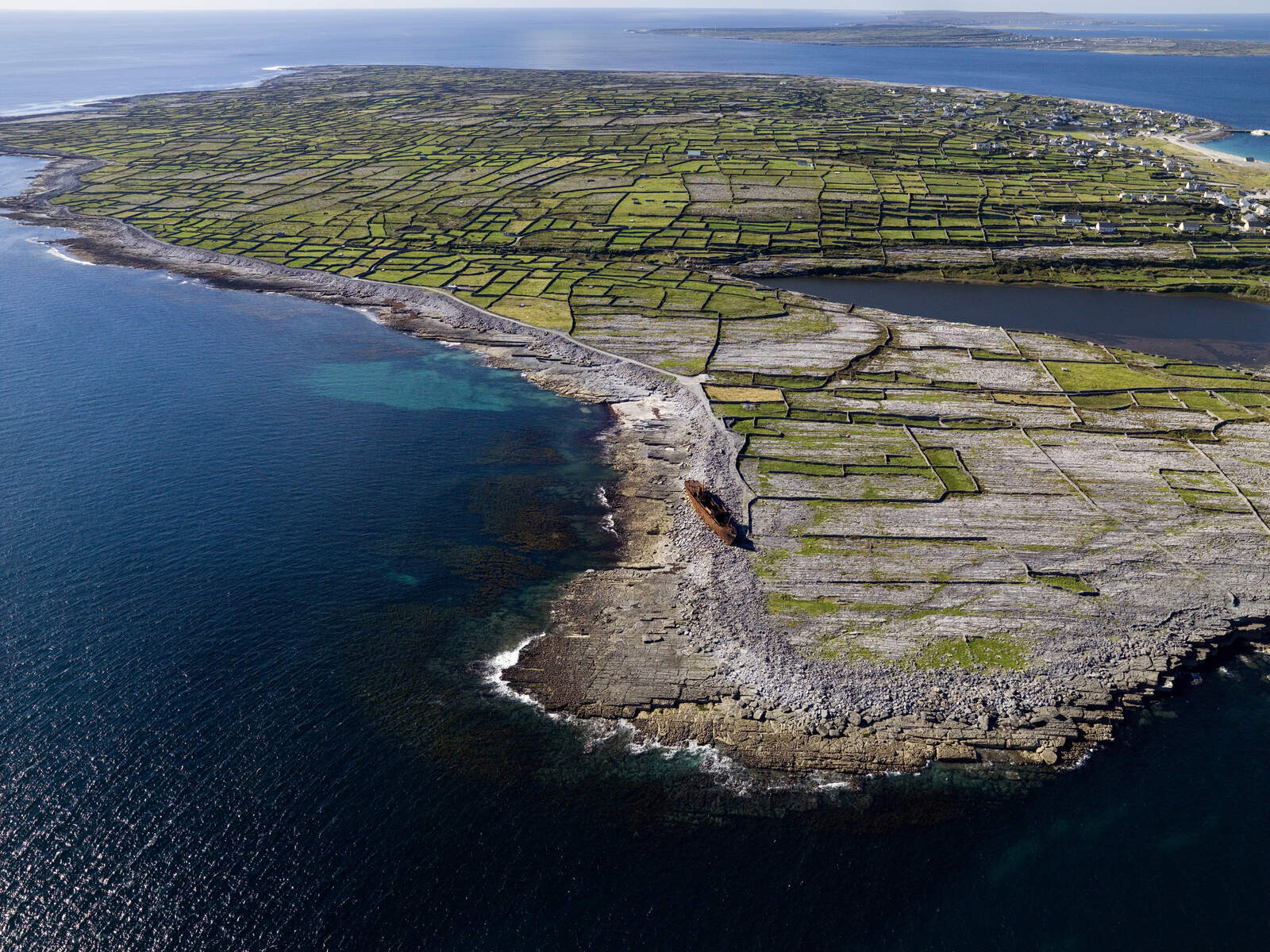
- MV Plassey shipwreck – Launched in Yorkshire in 1941 as the Royal Navy anti‑submarine trawler HMS Juliet, the vessel was sold after World War II, renamed Plassey in 1951 and used as a 600‑ton cargo freighter. On 8 March 1960 a ferocious Atlantic storm drove her onto Finnis Rock on Inis Oírr’s southeastern tip. Islanders rescued all eleven crew members with a breeches‑buoy, salvaged cargo, and the wreck later settled on the pebble beach where it remains a striking silhouette.
- St Caomhán (Sunken Church) – The 10th‑century stone chapel was erected over the grave of St Caomhán, a 6th‑century monk who founded a monastic settlement on the island. Over centuries wind‑blown sand buried the building, leaving only the chancel visible. In the 1980s locals excavated the site and built a protective wall to halt further encroachment.
- Dún Formna – The hilltop fort dates to the late Bronze Age (c. 400 BC) and originally protected livestock and people. In the 14th century the O’Brien clan added a three‑storey tower house within the ringfort walls – today known as O’Brien’s Castle – which later changed hands during the turbulent 16th‑ and 17th‑century conflicts.
What to See & Do
- Inis Oírr Lighthouse – Walk the coastal path from the pier to the lighthouse for panoramic views of Galway Bay, the Burren and, on clear days, the Cliffs of Moher. The lantern is not open, but the tower makes a striking photographic subject.
- Inis Oírr Pier – Arrive via the fast ferry from Doolin (15‑20 min) or the year‑round Rossaveal service (≈55 min). From the pier you can hire a bike, catch a pony‑and‑trap, or simply start a leisurely stroll. Small parking bays are available beside the pier; check for any seasonal fees.
- An Trá (Inis Oírr Beach) – A Blue Flag beach a stone’s throw from the pier, ideal for a dip, a sunset walk or a picnic with views of the Burren and Connemara.
- O’Brien’s Castle & Dún Formna – Climb the short hill from the pier to the 14th‑century tower house and the surrounding ringfort. The summit offers sweeping vistas of Galway Bay and the Cliffs of Moher.
- St Caomhán Sunken Church – Follow the sign‑posted coastal path to the shallow pit where the chancel peeks above the sand. The adjacent graveyard, including the roofed grave (Leaba Chaomháin), adds a solemn atmosphere.
- MV Plassey shipwreck at Finnis Rock – Walk or bike the 45‑minute coastal trail to the southeastern tip. The rust‑red hull against the Atlantic makes a dramatic backdrop for photos; the site is free and open year‑round.
- Coastal walks & cycling – The island’s network of paved and gravel paths links all the attractions, allowing visitors to explore at their own pace while enjoying wildflower‑dotted dunes and traditional stone walls.
Nearby attractions
- An Loch Mór – The large inland lake on Inis Oírr, known locally as “the big lake”, is a tranquil spot for bird‑watching and a pleasant walk away from the coastal routes. It lies a short distance inland from the pier and can be reached on foot or by bike.
- Mainland Gaeltacht villages – A short ferry crossing brings you to the Gaeltacht heartland of County Galway; consider a visit to An Spidéal for traditional music sessions and craft shops.
Practical Information
- Getting there: Fast ferry from Doolin (15‑20 min) and regular Rossaveal service (≈55 min). Ferries run multiple times daily in summer; check the latest timetable in advance.
- Transport on the island: Bike‑hire kiosks and pony‑and‑trap stands are located beside the pier. Both are inexpensive and provide a fun way to reach the lighthouse, Dún Formna and the shipwreck.
- Opening times: The lighthouse lantern is not open to the public. All other sites – pier, beach, St Caomhán, Dún Formna, O’Brien’s Castle and the Plassey wreck – are free and accessible year‑round.
- Facilities: A small café and souvenir shop operate near the pier. Restrooms are available at the pier and near An Trá beach.
- Best visiting times: Late spring to early autumn offers mild weather and longer daylight for the coastal walks. Early morning or sunset provide the most dramatic light for lighthouse and shipwreck photography.
- Safety: The coastal paths can be windy and uneven; sturdy footwear is recommended. The shipwreck area has slippery rocks, so keep a safe distance during high tide.
- Accessibility: The pier area is wheelchair‑friendly, but the hilltop walk to Dún Formna and the sunken church involve uneven terrain and are best suited to able‑bodied visitors.
Enjoy Inis Oírr’s blend of maritime heritage, ancient stonework and Atlantic scenery – all within a walkable island that feels both timeless and welcoming.