Overview
Joyce Country (Irish: Dúiche Sheóige) is a cultural landscape that stretches across the western counties of Galway and Mayo. Bordered by Connemara to the south and west, the region hugs the shores of Lough Mask and Lough Corrib and embraces the Partry Mountains, the Maumturk range and a patchwork of lakes, rivers and limestone karsts. It is part of the Joyce Country and Western Lakes Geopark, a UNESCO‑aspired area that showcases 700 million years of geological history alongside a living Irish‑language community.
The area is dotted with small villages – Clonbur, Cong, Cornamona, Toormakeady and Finny – each with its own story, traditional music sessions and welcoming pubs. Whether you are a hill‑walker, cyclist, angler, history buff or simply a lover of wild, unspoiled scenery, Joyce Country offers a compact yet diverse playground.
History
The name Joyce Country derives from the Norman‑origin Joyce (Seoighe) family who arrived in Connacht in the 13th century. The first recorded member, Thomas Joy, established a modest lordship in the barony of Ross, extending from the Cong River to the coast. Over the centuries the Joyces became fully Gaelicised, intermarrying with the O’Flahertys and other native clans, and their territory came to be known locally as Dúiche Sheóige – the land of the Joyces. The region retained its distinct identity through the turbulent Land War era of the 1880s, a period documented in Mary Lydon Simonsen’s book A Murderer’s Country.
Geology and Landscape
The geopark spans rock formations from the Precambrian to the Quaternary, illustrating Ireland’s journey from a young ocean near the South Pole to a tropical mountain range and finally to its present temperate climate. Volcanic activity left striking red rocks on the shores of Lough Nafooey, while the limestone plateau around Lough Mask displays classic karst features – clints, grikes and the famous Pigeon Hole Cave, where water from Lough Mask disappears underground and resurfaces in Lough Corrib.
A notable limestone pavement area, the largest outside the Burren, lies on the western side of Lough Mask. Restored under the EU LIFE‑Nature programme, it supports rare orchids, yew, and a variety of native trees, offering a unique glimpse of a habitat found nowhere else in Ireland.
Heritage and Culture
- Cong – Home to the 12th‑century Cong Abbey and the filming location for John Ford’s The Quiet Man. Nearby lies Caisleán na Circe, the ruined stronghold of pirate queen Grace O’Malley.
- Mount Gable – A 416 m ascent just outside Clonbur that provides a 360° panorama of Lough Corrib and Lough Mask. The climb is short and suitable for families; a local guide notes it as a popular birthday‑hike for children.
- Partry Mountains – Less‑trodden than the Twelve Bens, they offer rugged hill‑walking and spectacular glacial valleys.
- Joyce Country Sheepdogs – At Shanafaraghaun (near Finny) visitors can watch border‑collie demonstrations, see traditional hand‑shearing and meet the farm’s donkeys and puppies. The farm is run by fourth‑generation farmer Joe Joyce and provides a hands‑on insight into Connemara hill‑sheep farming.
- Guinness Limestone Pavement & Woodlands – The western Lough Mask limestone pavement, restored by Coillte under the EU LIFE‑Nature scheme, is the largest such area outside the Burren. The surrounding woodlands were replanted with native species, extending a historic yew stand that dates back to the original Guinness estate.
- Guinness Luncheon House Ruin – A quirky stone‑built ruin on the Lough Mask plateau, once used as a hunting lodge, now a photogenic spot for walkers.
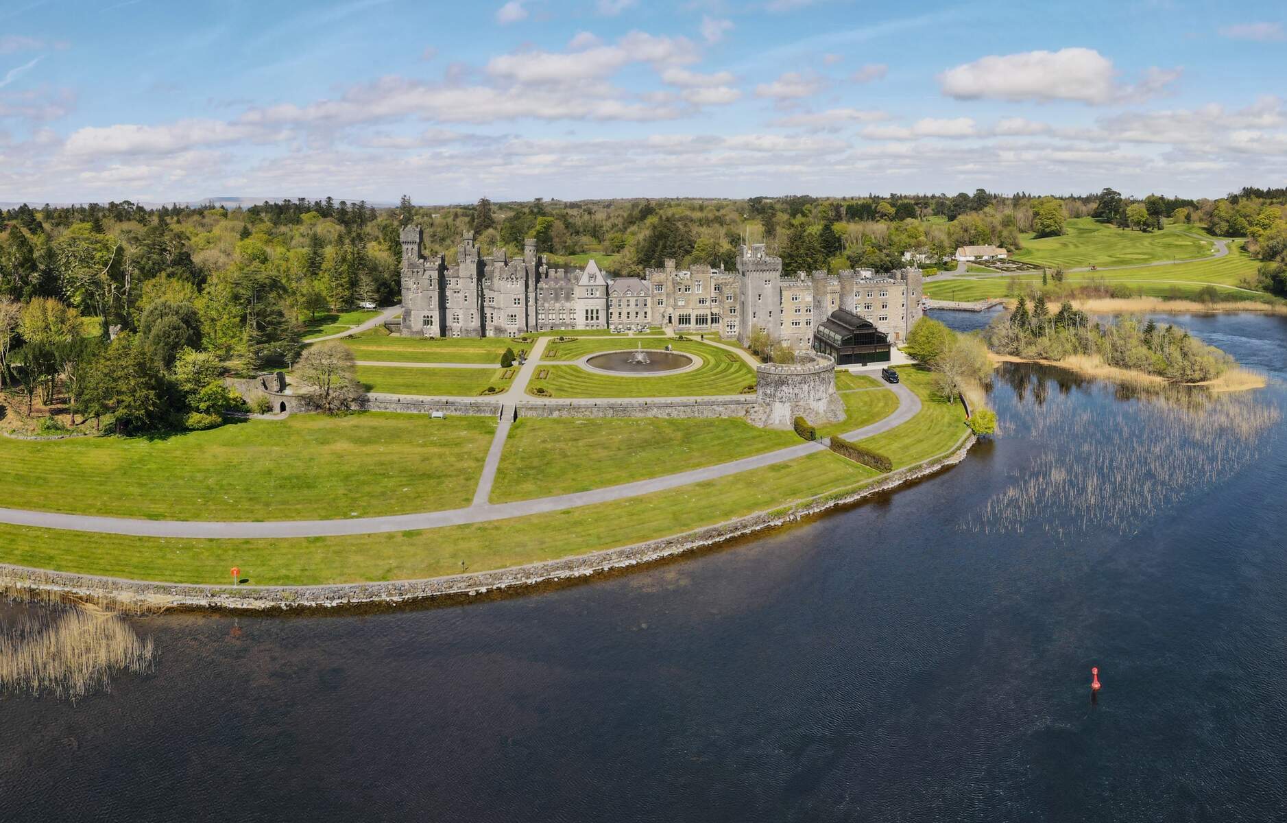
- Ashford Castle – The 13th‑century luxury hotel on Lough Corrib offers guided tours of its historic rooms and gardens. Ashford Castle tours must be booked in advance.
Walking and Hiking
Joyce Country is a hiker’s paradise. The Western Way, a 200 km long‑distance trail that links Oughterard (Co Galway) to Bunnycibbellan (Co Mayo), cuts through the geopark. In 2024 the trail was officially incorporated into the International Appalachian Trail, highlighting its ancient geological connections to North America. The section from Oughterard to Westport offers five manageable stages, for example Oughterard → Maam (24 km, 6‑8 hrs) and Maam → Leenaun (29 km, 6‑9 hrs). Some sections cross private land, so a quick knock on the nearest farm gate is courteous.
For a shorter taste, try the Murrisk Loop or the Murrisk Mountain Loop (both accessible from the Murrisk Pier). The Croagh Patrick Heritage Trail (63 km) provides a moderate walk that finishes with the famous mountain ascent, while the St Patrick’s Causeway (35 km) is a historic pilgrim path that requires a €10 registration fee and a declaration signed at Ballintubber Abbey.
Localised walks such as Seanbhóthar – a 10 km paved route between Corr na Móna and Clonbur – and the Cong Forest loop are perfect for families or those seeking a gentle ramble. The Mount Gable climb is a popular family‑friendly option, taking about 1‑2 hours round‑trip.
Hidden Valley of Lough Nafooey
A short drive into the “Hidden Valley” reveals a glacial lake framed by high mountains, a rare sandy beach at its western end and the striking red volcanic rocks that give the lake its name. It is an ideal spot for a picnic, shore‑fishing or photography.
Geotrail Mám Éan
In January 2024 the new Mám Éan Geotrail was launched on the Western Way at the historic Maam pass between the Maumturks and the Inagh Valley. Funded by a Geological Survey Ireland GeoHeritage grant and developed with the JCWL Geopark, the short trail features three interpretive panels that explain the Dalradian supergroup rocks (c. 700 Myr) and their links to the Appalachian range in North America. Guided walks are offered regularly, and the panels also explore local folklore and the ancient Saint Patrick pilgrimage route.
The geotrail adds a focused geological experience for visitors interested in the deep‑time story of Joyce Country and reinforces the Western Way’s status as part of the International Appalachian Trail.
Cycling
The geopark’s cycling network is extensive. The Great Western Greenway (42 km, traffic‑free) and Westport Greenway provide off‑road routes that showcase lakeside vistas and rolling hills. For road cyclists, the Westport Cycle Hub and National Coastal Trail link coastal villages with spectacular sea‑views. Mountain‑bike enthusiasts can tackle the Derroura Mountain Bike Trail or the Clonbur‑to‑Cong Wood loop.
Bike hire is available in Clonbur, Cong, Finny/Tourmakeady and Oughterard, and many Wild Atlantic Way operators also offer guided tours.
Water‑Based Activities
Lough Corrib, Lough Mask and Lough Carra are renowned for world‑class trout and salmon angling. The lakes are managed for sustainable sport fishing; anglers can obtain licences through Inland Fisheries Ireland. Boating, kayaking and paddle‑boarding are popular on the calm waters, especially around the hidden valley of Lough Nafooey, where a sandy beach and striking red volcanic rocks create a photogenic backdrop.
The Abbert River – a celebrated trout fishery – lies on the western edge of the geopark and offers easy access for fly‑fishers. (See also the nearby Abbert River page.)
Joyce Country Sheepdogs – Visitor Details
The farm runs daily demonstrations at 11:00, 13:00 and 15:30 (Monday‑Saturday) from 1 March to 18 October. Admission (2025 rates) is €15 for adults and €5 for children under 12; groups of 15 + receive a reduced rate. No advance booking is required, though private demos can be arranged by prior arrangement. The farm also sells Border‑Collie puppies and a small shop offering locally made wool products.
Film & Cultural Highlights
- The Quiet Man – Cong’s iconic bridge and surrounding streets were used extensively in John Ford’s 1952 classic. Fans can walk the same routes as John Wayne and Maureen O’Hara.
- Caisleán na Circe – The ruins of Grace O’Malley’s stronghold sit on a small island in Lough Corrib, reachable by a short walk from Cong.
- Local music sessions – Most villages host nightly traditional music in pubs; the schedule varies seasonally, so check local notice‑boards.
Seasonal Highlights
- Spring (April‑June) – Salmon runs in Lough Corrib and Lough Mask; ideal for angling and wildflower walks.
- Summer (July‑August) – Longer daylight for hill‑walking; numerous food fairs and craft markets in Cong, Clonbur and Finny showcase local produce and Irish‑language storytelling.
- Autumn (September‑October) – Peak of trout fishing; the landscape turns gold, perfect for photography.
- Winter (November‑March) – Lakes reach full depth, revealing the “dry canal” in Cong; quieter trails are ideal for peaceful walks.
Nearby Attractions
- Aughnanure Castle – A well‑preserved 16th‑century tower house just a short drive from Cong. /aughnanure-castle/
- Kylemore Abbey & Victorian Walled Garden – Set on the shores of Lough Kylemore, the abbey offers guided tours, a beautiful garden and a glimpse of monastic life.
- Killary Fjord Boat Tours – From the village of Leenane, boat trips explore Ireland’s only fjord, offering wildlife spotting and dramatic mountain scenery.
- Connemara Sheep & Wool Centre – Located in Leenane, this centre tells the story of the Irish wool industry with live demonstrations.
Practical Information
Joyce Country is largely open landscape, so most attractions have free entry. The only fee mentioned in official sources is the €10 registration for the St Patrick’s Causeway pilgrimage; bookings can be made via the Ballintubber Abbey website.
| Activity | Fee (if any) | Booking / Notes |
|---|---|---|
| St Patrick’s Causeway | €10 registration | Register online at Ballintubber Abbey; walk in pairs |
| Ashford Castle tours | Varies – check the castle’s website | Advance reservation recommended |
| Joyce Country Sheepdogs | Adults €15, Children €5 (2025) | Demonstrations 11 am, 1 pm, 3.30 pm Mon‑Sat; open 1 Mar‑18 Oct; no booking needed |
| Mám Éan Geotrail | Free | Self‑guided; panels open year‑round |
Getting there – The region is well‑served by regional roads. The nearest airports are Ireland West Airport Knock (Co Mayo) and Galway Airport. Public transport options include Bus Éireann routes to Clonbur, Cong and Westport; bicycles can be taken on most services (subject to size limits and a modest fee). Parking is free at most trailheads, including the Oughterard car park for the Western Way and the Cong car park for lake‑side walks.
Dog‑friendly – Dogs are welcome on most walking and cycling routes provided they are kept on a leash and under control, especially where livestock are present.
Accessibility – Some short loops such as the Cong Forest and Mount Gable are suitable for wheelchair users and families with prams; longer mountain routes may be uneven and require a reasonable level of fitness.
Safety – Some long‑distance walks cross remote terrain; walkers should carry a fully charged mobile phone, a basic first‑aid kit and sufficient water. The Western Way includes over 100 stiles; the St Patrick’s Causeway has 113 stiles and requires walkers to be in pairs for health‑and‑safety reasons.
Language – Irish is the everyday language in many villages; signage is bilingual, and cultural centres such as the People & Culture page on the geopark website offer short language guides for visitors.
Events & Festivals
The area hosts a number of seasonal music sessions, food fairs and cultural festivals, particularly in Cong, Clonbur and Finny. Dates vary each year; visitors are advised to check the Joyce Country Geopark website or local tourist information centres for the latest programme.
Further resources
- Interactive map of trails: Joyce Country Geopark Map
- Detailed walking‑trail information: Irish Trails
- Cycling route planner: Sport Ireland Cycling Trails
- Angling licences: Inland Fisheries Ireland
- Joyce Country Sheepdogs website: Joyce Country Sheepdogs
- Guided tour contacts: Galway Tour Guides Association / Approved Tourist Guides of Ireland
Enjoy the whispering landscape of Joyce Country, where ancient geology, Gaelic culture and modern adventure converge in a truly unforgettable Irish experience.