Overview
Muldersleigh Hill is a modest but charismatic rise in the Belfast Hills, standing at 131 m (430 ft) with a prominence of 106 m. The summit is marked by a well‑structured trig point, an ancient stone marker and a pleasant rock outcrop that makes an ideal spot for a quick snack or a selfie. The hill’s terrain is a mix of grassy slopes dotted with limestone and sandstone outcrops, giving the landscape a rugged, almost volcanic feel. From the top you can see the dramatic coastline of Belfast Lough, the rolling fields of Islandmagee, and on a clear day the distant spires of Whitehead and even the Copeland Islands.
History & Heritage
The name Muldersleigh is thought to derive from a local dialect meaning “mud hill”, a nod to the rich, fertile soils that once supported intensive agriculture and sheep farming in the area. The hill also holds a fascinating maritime legacy. In 1665 Sir Robert Reading was granted a patent to erect six lighthouses around Ireland, one of which was placed on the summit of Muldersleigh Hill to guide ships into Belfast Lough. Contemporary accounts – notably Rev. James O’Laverty’s 1833 Historical Account of the Diocese of Connor – mention “the ruins of a lighthouse” on the hill, and 1690 maps label the summit with the words “Old Tower”.
The 1665 Lighthouse Patent and Lease
The original patent allowed Reading to charge ships a toll for the light’s upkeep: 1d per ton for British and Irish vessels on outward journeys and 2d per ton for foreign ships in either direction. A 1704 petition shows the tolls were later limited to foreign ships only, reducing income dramatically. Records from the Town Book of Belfast (1667) note that Richard, Earl of Arran held a lease on the “lighthouse at Island Magee”, which was transferred to the Earl of Abercorn after Reading’s daughter married James Hamilton. The lighthouse is believed to have been operational for less than three years before the coal‑braziers proved uneconomic to maintain on the hill’s summit.
Modern Debate on the Lighthouse’s Exact Site
A 2020 blog post revisits the evidence, citing:
- O’Laverty’s 1833 description of ruins on Muldersleigh.
- A 1690 map marking the summit as “Old Tower”.
- Griffith’s Valuation (mid‑1800s) noting “(Site of) Light Ho.” on the hill.
- Archaeological surveys (2010, 2011) confirming physical remains at the summit.
These sources together make a strong case that the short‑lived “Isle of Magee” lighthouse was indeed sited on Muldersleigh Hill, despite later confusion with the Copeland Islands.
Geology & Landscape
According to MountainViews, Muldersleigh Hill sits on olivine basalt lava of the Lower Basalt Formation, part of the Antrim basaltic plateau that stretches across the north‑east of the island. The basalt gives the hill its dark, rugged outcrops and contrasts with the surrounding limestone and sandstone patches. The hill is the second most southerly and second most easterly summit in the Antrim Hills, and the fourth most easterly summit in all of Ireland. Its isolation of 3.3 km makes it a distinct landmark for walkers navigating the coastal route.
Archaeological Survey
A review of rectangular‑plan earthwork enclosures in counties Antrim and Down (Ulster Journal of Archaeology, 2011) records several unexcavated rectangular structures on Muldersleigh Hill. While their date is uncertain, the presence of these features suggests the hill was used for settlement or defensive purposes long before the 17th‑century lighthouse.
Visitor Numbers & Popularity
Comments on MountainViews highlight that Muldersleigh Hill may be “the most visited top in Ireland” – with over 200 people climbing every Saturday between April and October and steady numbers on other days. The easy ascent (about 1.25 km with a 60 m climb) and the panoramic sea views contribute to its popularity among locals, families and walking groups.
What to See & Do
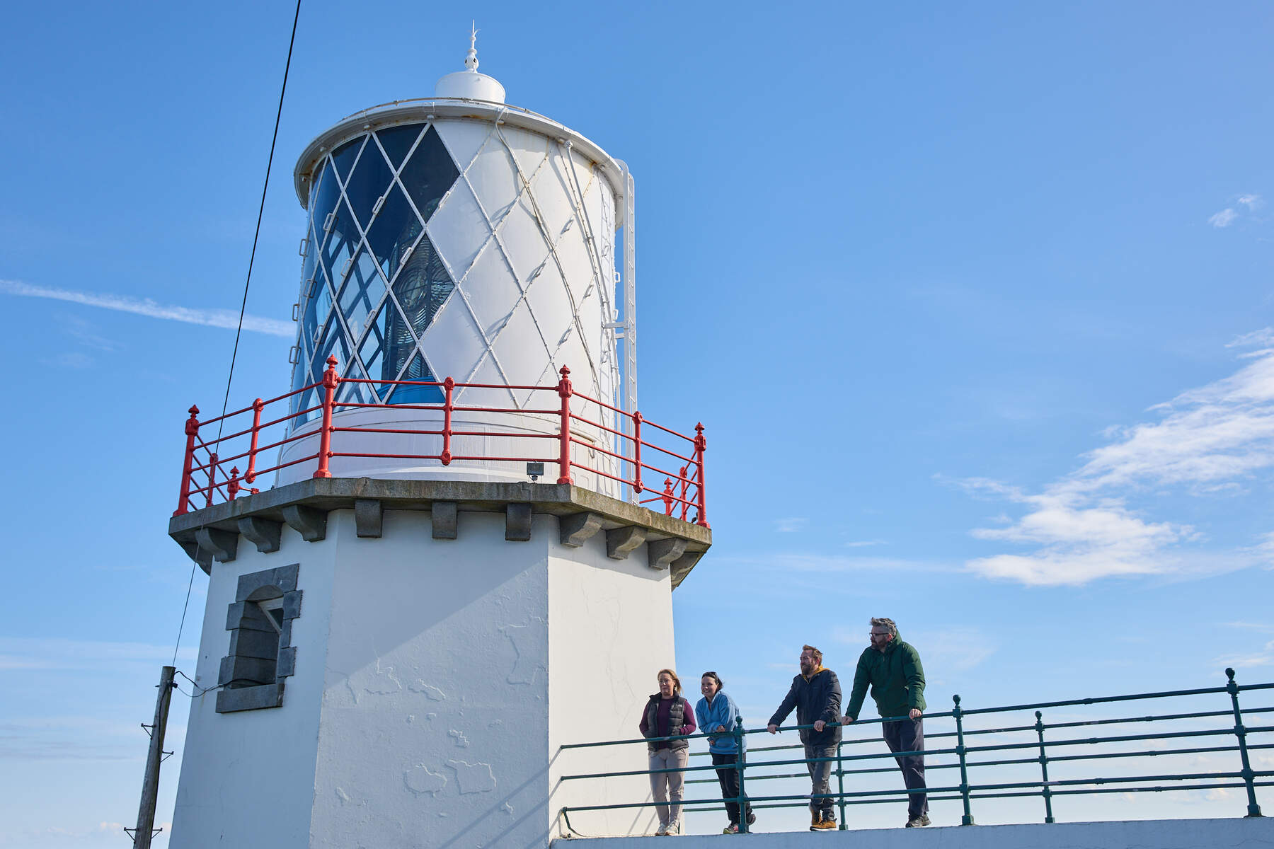
- Summit Highlights – The trig point, stone marker and rock outcrop provide a natural viewing platform. The site also offers a glimpse of the historic lighthouse ruins, still visible as faint stone foundations on the summit.
- Geology – Walkers will notice the limestone pavements and sandstone cliffs that give the hill its distinctive character. The underlying basalt adds a darker tone to the landscape.
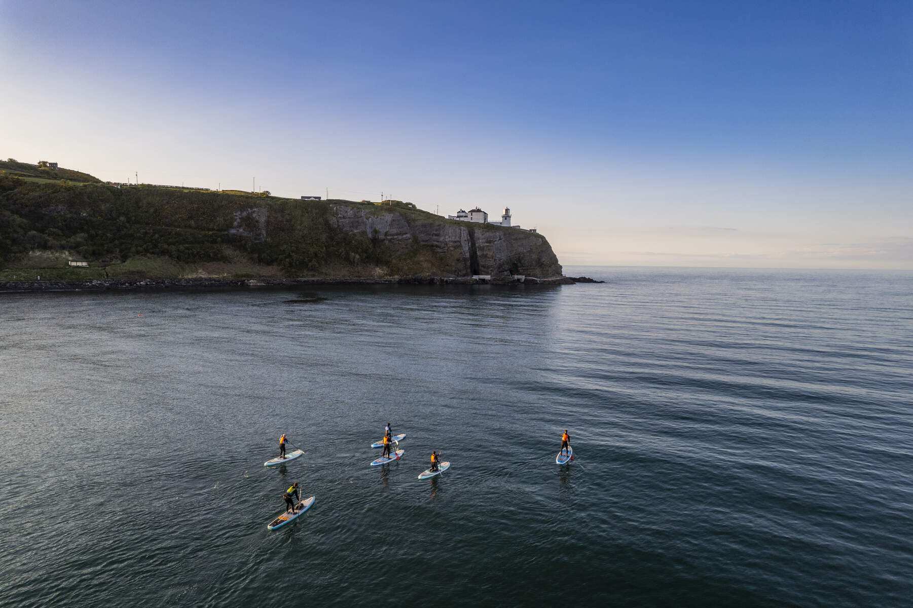
- Coastal Views – Looking east across Belfast Lough you can spot the Blackhead Lighthouse, the Copeland Islands, and the village of Whitehead. To the north‑west the Mourne Mountains loom on the horizon, while the Irish Sea stretches towards Scotland.
- Recreational Links – The hill forms part of the Blackhead Coastal Path Walk, a 5 km route that starts at Blackhead Car Park, passes the iconic Blackhead Lighthouse, then contours the slopes of Muldersleigh Hill before joining the B150 road. The path is also featured on the Antrim Coast and Glens tourism trail, offering opportunities to spot seals, seabirds and, on lucky days, pods of dolphins.
- Whitehead Golf Club – Situated on the southern flank of the hill, the club’s 18‑hole course (opened 1975) was laid out on former farmland and offers spectacular sea‑view fairways. The club’s history, dating back to 1904, is intertwined with the hill: the original clubhouse was at the base of Muldersleigh, and the trig pillar sits in the centre of the third fairway. Non‑members may park in the club car park (McCrea’s Brae) and walk the hill after checking in at the pro‑shop.
- Family Walks – A popular moderate route begins at Upper Hulme, winding through gentle countryside for 5 km (≈2.5 hours). The gradient is mild, making it suitable for families and casual walkers.
Wildlife & Birdwatching
The coastal sections of the Blackhead Path are frequented by seals and a variety of seabirds such as gulls, razorbills and guillemots. During the summer months, dolphin pods have been reported off Belfast Lough, adding a memorable wildlife element to the walk.
Practical Information
Getting There
- Parking – A small car park at Upper Hulme accommodates about 15 vehicles and fills quickly on weekends; early arrival is advisable.
- Public Transport – Regular bus services run from nearby towns such as Buxton and Leek to Upper Hulme. Check the latest timetables before you travel.
- Road Access – The Blackhead Lighthouse road is a private, resident‑only route; however the coastal path and country road that skirt Muldersleigh Hill are open to pedestrians and cyclists.
- Golf Club Access – The most convenient car park is the Whitehead Golf Club car park (McCrea’s Brae). Permission to walk the hill is normally granted at the pro‑shop; walkers should be mindful of golfers, especially on Saturdays when the club is busiest.
- Grid Reference & Maps – Summit grid reference J47955 93812 (OSNI map sheets 15 & 4). The hill is listed on MountainViews as summit 1365.
Facilities
- Toilets – Available at the Upper Hulme car park.
- Refreshments – While there are no cafés on the hill itself, Upper Hulme hosts a cosy tea room where you can enjoy homemade cake after your walk. The nearby village of Whitehead offers a range of cafés and pubs along the promenade.
Navigation & Safety
- The summit is clearly signposted with the trig point and stone marker. A modest looking‑post from the Great War remains on the top, offering a historic reference point.
- The terrain can become slippery after rain, especially on the limestone sections. The Blackhead Coastal Path includes some steep steps near the lighthouse, so watch your footing.
- The hill is part of a larger network of World War II fortifications; while they are safe to view, they are not intended for climbing.
- Note that the trig point is not the absolute highest spot – a small stony bank a few metres east of the pillar is marginally higher.
Accessibility & Pets
- Wheelchair access – The path to the summit involves uneven grassy and rocky ground and a series of steps near Blackhead Lighthouse, making it unsuitable for wheelchair users.
- Dog‑friendly – The coastal path is generally open to dogs, but there is no official guidance specific to Muldersleigh Hill. Walkers should keep dogs on a leash and respect any local signage.
Seasonal Highlights
Spring and summer bring the best chance of spotting seals, seabirds and occasional dolphin pods from the coastal sections of the walk. Autumn offers striking colours across the fields of Islandmagee, while winter can bring brisk sea breezes and dramatic cloud‑filled skies – just be prepared for wetter conditions on the limestone outcrops.
Suggested Itinerary
- Start at Upper Hulme – Park, grab a tea, and begin the 5 km moderate loop.
- Reach the Summit – Pause at the trig point, take in the panoramic views, and locate the faint lighthouse foundations.
- Descend via the Blackhead Coastal Path – Follow the coastal trail to Blackhead Lighthouse, then continue westward along the country road that skirts the hill.
- Finish in Whitehead – Explore the village, visit the golf club’s restaurant, or simply relax at a seaside café.
Nearby Attractions
Muldersleigh Hill sits within the scenic stretch of the Antrim Coast and Glens, a designated Area of Outstanding Natural Beauty. After your walk you might continue along the coastal route to explore the historic Blackhead Lighthouse, the charming harbour of Whitehead, or venture further north to the dramatic cliffs of Ballycastle.
Muldersleigh Hill may be modest in height, but its blend of natural beauty, geological intrigue and layered history makes it a rewarding destination for anyone exploring County Antrim’s coastal hinterland.