Overview
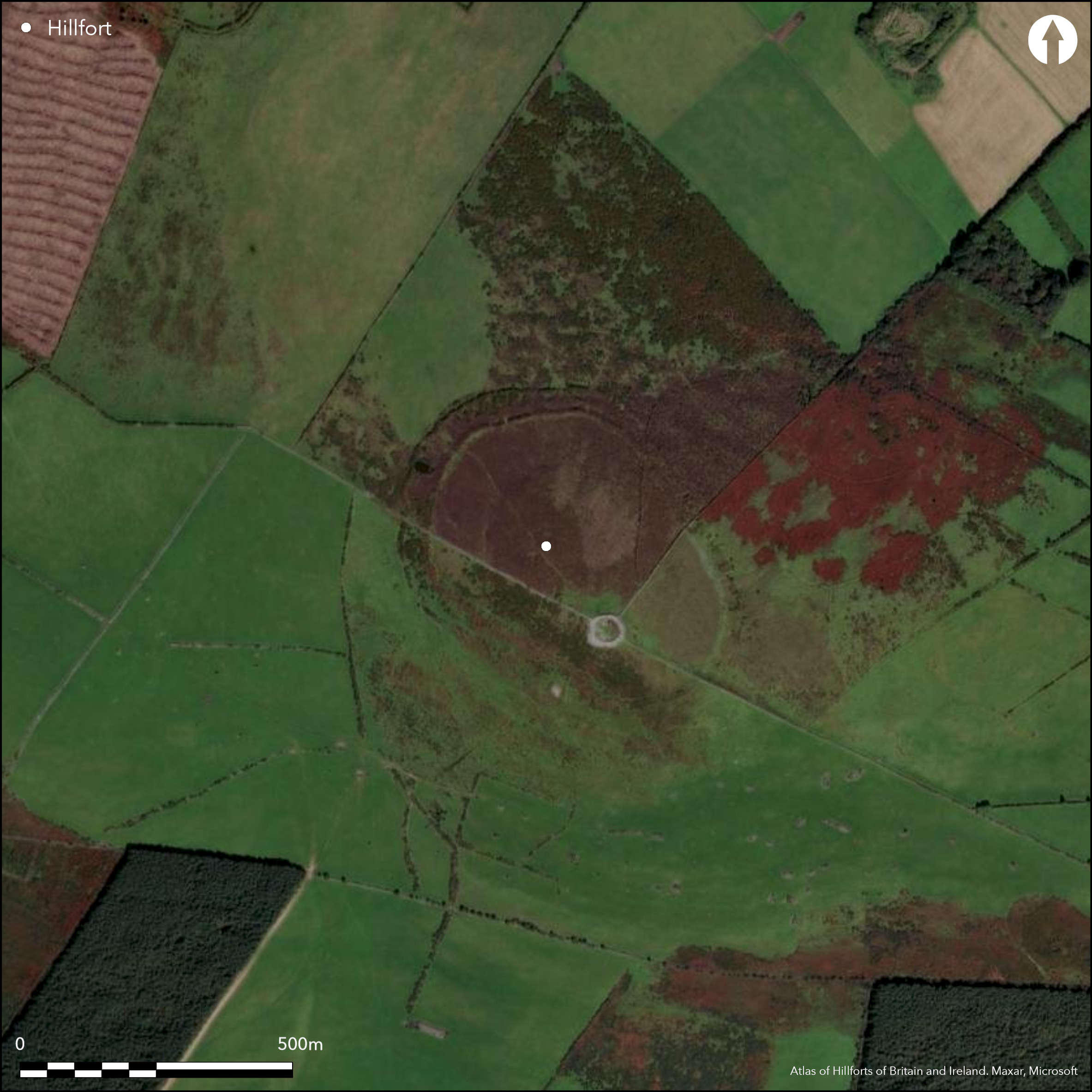
Rathcoran crowns the summit of Baltinglass Hill (also known as Tuckmill Hill) at roughly 370 m above sea level. What makes this site stand out is its unusual chronological layering: a Neolithic passage tomb dating to around 3500-3000 BC sits inside a later Bronze Age hillfort built roughly a millennium after. The double stone-earth ramparts that enclose the cairn give the hilltop a distinctive, fortress-like profile, while the open summit rewards visitors with clear sightlines across the River Slaney valley and the rolling farmland of south-west Wicklow.
A Layered Prehistoric Landscape
The Neolithic passage tomb
The burial monument at Rathcoran was constructed during the same period as the great passage tombs of the Boyne Valley. Archaeologist P. T. Walshe excavated the site between 1934 and 1936, uncovering a north-side chamber measuring about 1.2 m across. Inside, he found the cremated remains of at least three adults and a child, along with flint scrapers, bone pins, a stone axe, and pottery stylistically linked to the Carrowkeel complex in Sligo.
What’s particularly striking is evidence of early farming at altitude. Carbonised hazelnuts, wheat grains, and a saddle quern recovered from the site suggest the builders cultivated crops and processed grain well above the modern tree line. Fragments of quartz scattered through the fill hint at decorative intent, possibly used to catch sunlight on the cairn’s surface. Today, the main chamber still holds three shallow recesses and a stone basin with a smooth, concave surface, while a secondary south-side tomb displays carved passage-tomb art on two of its upright stones.
The Bronze Age hillfort & Iron Age settlement
Around 1000 BC, a new community returned to the summit and began constructing a bivallate (double-ramped) ringfort around the ancient cairn. The Irish name Ráth Cuaráin or Ráth Charnáin likely translates to “ringfort of the cairn,” reflecting how the later builders deliberately incorporated the older monument into their defensive layout. The ramparts follow the hill’s natural contour, reaching up to 16 m wide and nearly 3 m high on the northern and north-western flanks.
Archaeological assessment suggests the fort was never fully finished. Quarry pits and abruptly terminating banks point to a sudden halt in construction, though the site remained active. Modern LiDAR and geophysical surveys have mapped up to fifty circular hut platforms within the enclosure, indicating substantial Iron Age occupation long after the ramparts were laid. Today, dense gorse and scrub cloak much of the interior, preserving the layout while giving the hilltop a quiet, windswept atmosphere.
What to See & Do
- Explore the chambers – The main north chamber and the secondary south tomb are the clearest features to locate. Look for the carved motifs on the south-side stones and the smooth basin in the central chamber. A smaller corbelled structure sits to the north-west, and a fifth chamber rests within the outer kerb to the east.
- Trace the ramparts – The inner and outer banks are most visible on the northern approach. Walk along the surviving sections to feel the scale of the defensive work. Faint magnetic anomalies recorded in surveys suggest a wooden palisade may have once topped the inner bank.
- Take in the views – The summit offers unobstructed sightlines across the Slaney valley and the town of Baltinglass. On clear days, the Sugarloaf peak stands out on the horizon, providing a useful landmark for orientation.
- Read the landscape – Rathcoran is one of nine hillforts in the immediate Baltinglass area. The surrounding scrub and field boundaries hint at centuries of human activity, from early farming to medieval settlement.
Getting There & Visitor Info
- Access – A minor road climbs from Baltinglass, roughly 2 km east-north-east of the town centre. A small car park sits at the terminus; from there, an unpaved trail leads directly to the summit. The ascent is short but steep in places and best suited to reasonably fit walkers.
- Parking & Facilities – Free parking is available at the trailhead. There are no toilets, shop facilities, or visitor centre on site, so bring water and snacks.
- Accessibility – The route crosses uneven ground, steep sections, and low scrub. Sturdy footwear is strongly recommended. The site is not wheelchair-accessible.
- Opening times & Admission – As a protected National Monument, Rathcoran is open year-round with free entry. There are no staffed hours or ticketing; visitors manage their own visit.
- Dog-friendly – Dogs are welcome but must be kept under close control, particularly during spring and early summer when ground-nesting birds use the scrub.
- Safety – The summit is fully exposed to wind and weather changes. Check the forecast, bring a wind-proof layer, and allow extra time if visibility drops.
For satellite imagery and archaeological mapping, the Hillforts Atlas provides a detailed overhead view of the enclosure and surrounding landscape.
Nearby Attractions
- Baltinglass Abbey – A well-preserved 12th-century Cistercian abbey located in the town of Baltinglass, easily combined with a visit to Rathcoran.
- Keadeen Mountain – Offers additional walking routes and elevated views across the same valley system.
- The Sugarloaf – The iconic conical peak visible from Rathcoran on clear days, with its own network of walking paths.
- Dwyer-McAllister Cottage – A historic thatched cottage near the Sugarloaf, showcasing traditional Wicklow building methods.
Further Reading
The original excavation report by P. T. Walshe (1941) remains the foundational account of the passage tomb, while recent LiDAR and geophysical studies have updated our understanding of the hillfort’s layout and Iron Age occupation. Local heritage groups and the Office of Public Works also publish walking guides that place Rathcoran within the wider Baltinglass prehistoric landscape.