Overview
Ravensdale Forest lies on the southern slopes of the Cooley Peninsula, about eight kilometres north of Dundalk. Managed by Coillte, the forest is a mixed‑woodland area that climbs steeply to the summit of Black Mountain (506 m). Visitors can roam a network of forest roads and tracks that link three way‑marked routes – the Tain Trail, the Ring of Gullion and the short Ravensdale Loop. The site is open year‑round, although access may be temporarily restricted after severe storms while safety signage is updated.
The forest is not only a haven for walkers; it is dotted with archaeological features, including several standing stones, a picturesque stone bridge and the remnants of old driving roads. A downloadable trail map is available from Coillte.
History & Background
The land that now forms Ravensdale Forest was once part of the extensive estate of Lord Clermont, who owned over 20,000 acres in County Louth. The forest tracks were originally private lanes used by the estate’s tenants and later incorporated into the public trail network. The area’s rich archaeological record – standing stones, cairns and historic bridges – points to human activity dating back to the Bronze Age, making the forest a living museum of Louth’s ancient past.
What to See & Do
Walking Trails
| Trail | Length | Markers | Difficulty |
|---|---|---|---|
| Ravensdale Loop | 1.3 km | Red | Moderate |
| Ravensdale Forest Circular | 8.5 km | Red/Blue (mixed) | Moderate |
| Tain Trail (section) | Variable | Yellow | Moderate |
| Ring of Gullion (section) | Variable | Blue | Moderate |
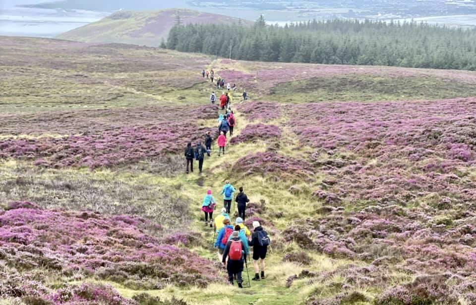
The Ravensdale Forest Circular is a favourite among locals and visitors alike. Starting from the tiny car‑park at the trailhead, the route climbs an uneven, mucky path before opening onto a gravel track. After about 15‑20 minutes the trail levels out and offers intermittent views of the surrounding countryside. Mid‑way, a short detour leads to a cluster of standing stones and a Lord‑of‑the‑Rings‑style stone bridge that frames the forest canopy.
For those seeking a shorter stroll, the Ravensdale Loop (1.3 km) provides a quick immersion in commercial forest scenery, marked by red posts. The loop is suitable for families with children who can manage a modest incline.
Archaeological Highlights
- Standing Stones – A small group located just off the circular route, offering a tangible link to prehistoric ritual landscapes.
- Clermont Cairn – A burial cairn that hints at Bronze‑Age activity in the area.
- Historic Bridge – An elegant stone bridge spanning a forest stream, often photographed for its fairy‑tale appearance.
Picnic & Rest Areas
A designated picnic site sits near the car‑park, providing a pleasant spot to refuel after the walk. The forest’s car‑park is modest in size; on busy days it can fill quickly, especially during fine weather.
Nearby Attractions
- Cooley Peninsula Drive – A scenic two‑hour loop that can be started from Ravensdale, showcasing coastal vistas, beaches and additional historic sites.
- Annaloughan Loop Walk – An 8 km loop beginning at Fitzpatrick’s Bar, just a short drive away.
- Carlingford – Approximately 25 minutes by car, offering castles, the Carlingford Greenway and the Slieve Foye Loop.
Practical Information
- Getting There: The forest is reachable via the R173 road from Dundalk. Google Maps coordinates are 54.0751 N, ‑6.34666 W. A direct link to directions is provided on the Coillte page.
- Parking: A small on‑site car‑park is available at the trailhead. It can become full on popular days; early arrival is advisable.
- Facilities: The site offers a car‑park, picnic area and marked walking trails. No permanent visitor centre or restroom facilities are listed.
- Admission: Free entry; no fee is required to access the trails.
- Trail Conditions: Paths are generally in good condition but can become mucky after heavy rain, especially on the initial uneven section of the circular walk.
- Maps & Resources: A PDF trail map can be downloaded from Coillte (Ravensdale Trail Map). Additional information is available on the Louth Tourism and Discover Ireland websites.
Website: https://www.coillte.ie/site/ravensdale-forest/
Further Reading
- Louth Tourism: https://www.visitlouth.ie/
- Discover Ireland: https://www.discoverireland.ie/
- Ring of Gullion walking information: https://ringofgullion.org/things-to-do/activities/walking/long-walks/
Ravensdale Forest remains one of County Louth’s quieter natural gems, offering a blend of woodland serenity, archaeological intrigue and rewarding vistas without the crowds that flock to the nearby coastal towns.