Overview
The Burren (Irish: Boireann, meaning “rocky place”) dominates the north‑west of County Clare with its moon‑lit limestone pavements, craggy cliffs and a mosaic of habitats that support more than 70 % of Ireland’s native plant species. Designated as a UNESCO Global Geopark, the area stretches from the Atlantic coast at Lahinch and the Cliffs of Moher inland to the villages of Lisdoonvarna, Corofin and Kilfenora. While the core karst uplands cover roughly 250 km², the broader Burren region can be as large as 560 km², depending on the definition used.
History & Heritage
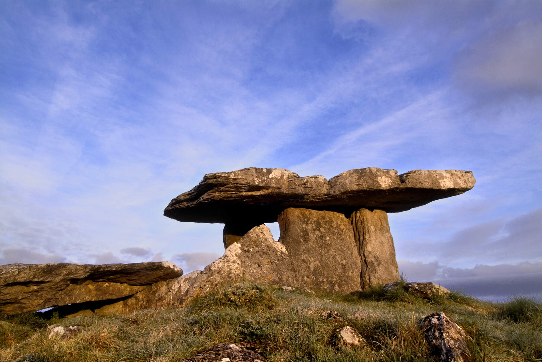
Human activity in the Burren dates back at least 33 000 years, with Ice‑Age hunters leaving butchered bone assemblages in caves. By the Neolithic (c. 4000 BC) early farmers had cleared much of the original woodland, erected stone walls and built the first megalithic monuments. The most iconic of these is Poulnabrone Dolmen, a portal tomb dating to 3800‑3200 BC that still shelters the skeletal remains of 33 individuals.
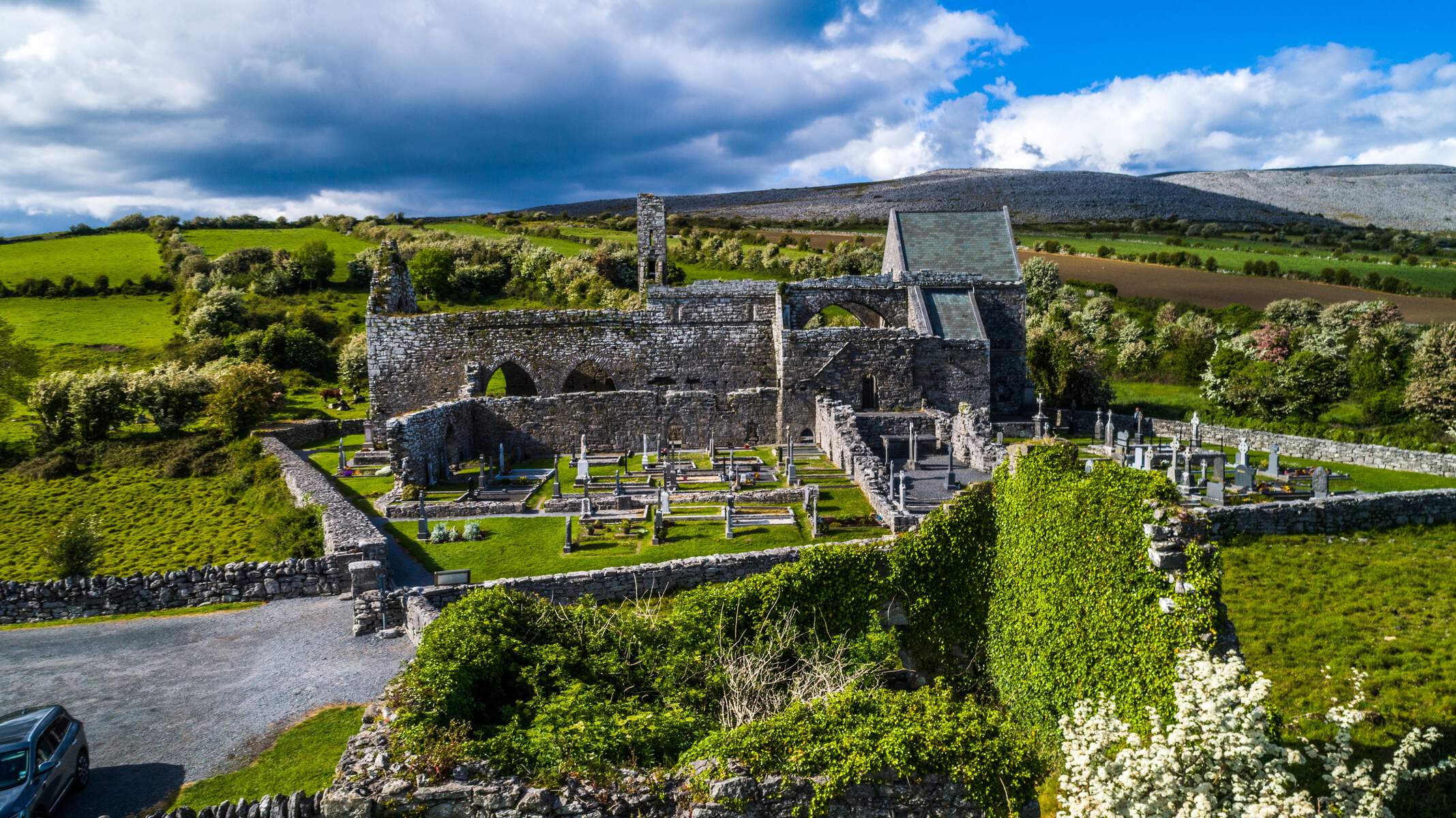
Later Bronze‑Age communities added over 300 fulachtai fiadh (ancient cooking pits) and a wealth of wedge‑tombs, especially on Roughan Hill near Kilnaboy. Medieval times saw the rise of stone forts such as Caherconnell (a 1 000‑year‑old ringfort) and the Cistercian Corcomroe Abbey, founded in the early 13th century. The O’Loughlin clan ruled the Burren until the mid‑17th century from Gregans Castle, while the O’Briens of Thomond later asserted control over the region.
What to See & Do
| Attraction | Type | Highlights |
|---|---|---|
| Poulnabrone Dolmen | Prehistoric tomb | Neolithic burial chamber, free to visit |
| Caherconnell Stone Fort | Ringfort | 3 m high limestone walls, seasonal sheep‑dog demonstrations |
| Aillwee Cave & Birds of Prey Centre | Show cave | Underground river, stalactites, bear bones, live raptor displays |
| Doolin Cave | Show cave | Europe’s largest stalactite (7.3 m) |
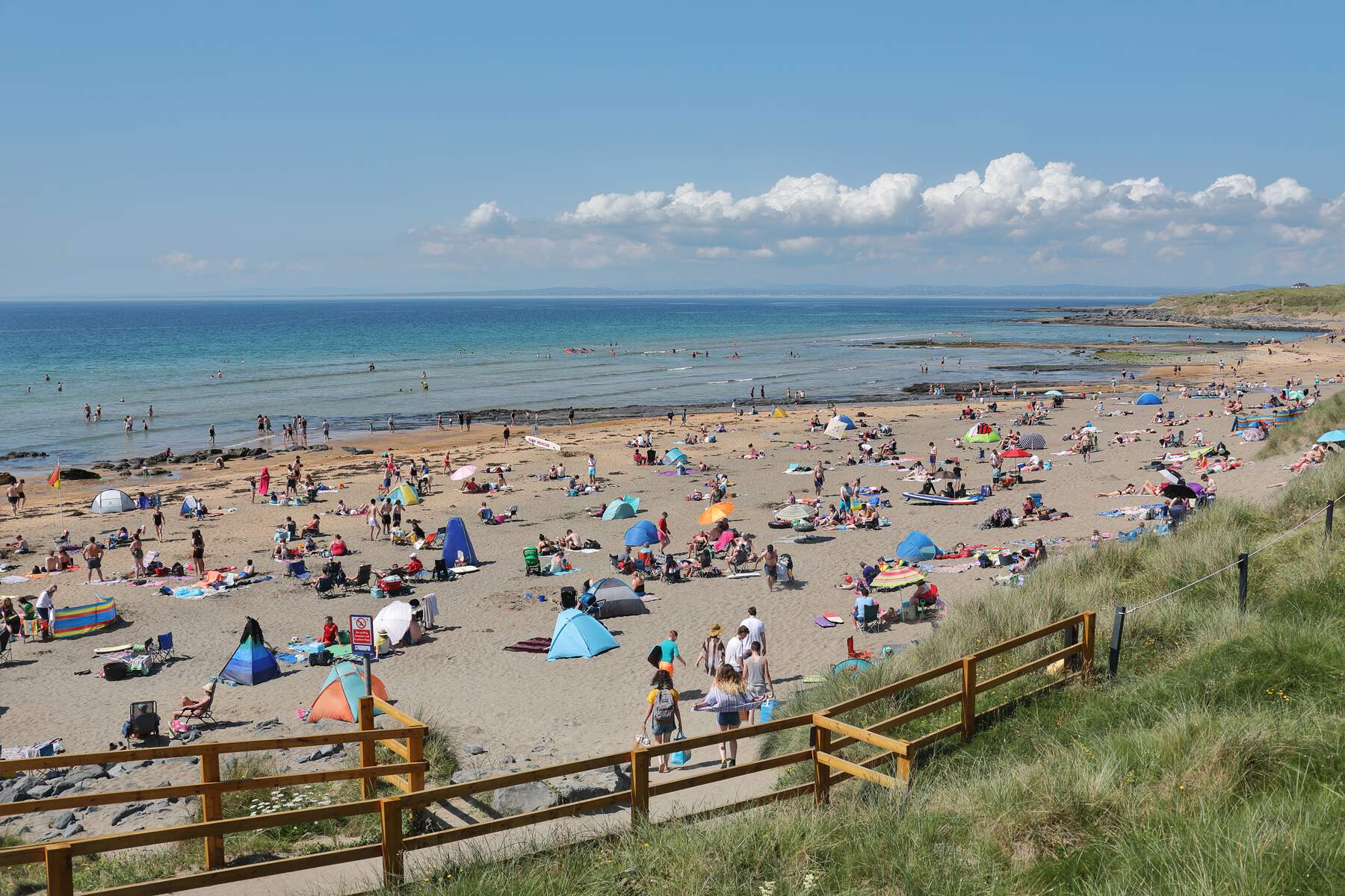
| Fanore Beach | Blue‑Flag beach | Golden sand backed by limestone cliffs |
| Blackhead Lighthouse | Maritime landmark | 8 m tower, views of the Aran Islands |
| Burren National Park | Protected area | 1 500 ha of karst scenery, visitor information point at Corofin |
| Burren Way | Long‑distance trail | 114 km walk from Lahinch to Corofin, passes cliffs, forts and villages |
| Burren Food Trail | Gastronomic route | Artisan cheese at Aillwee, farm‑to‑fork meals, smoked salmon at Burren Smokehouse |
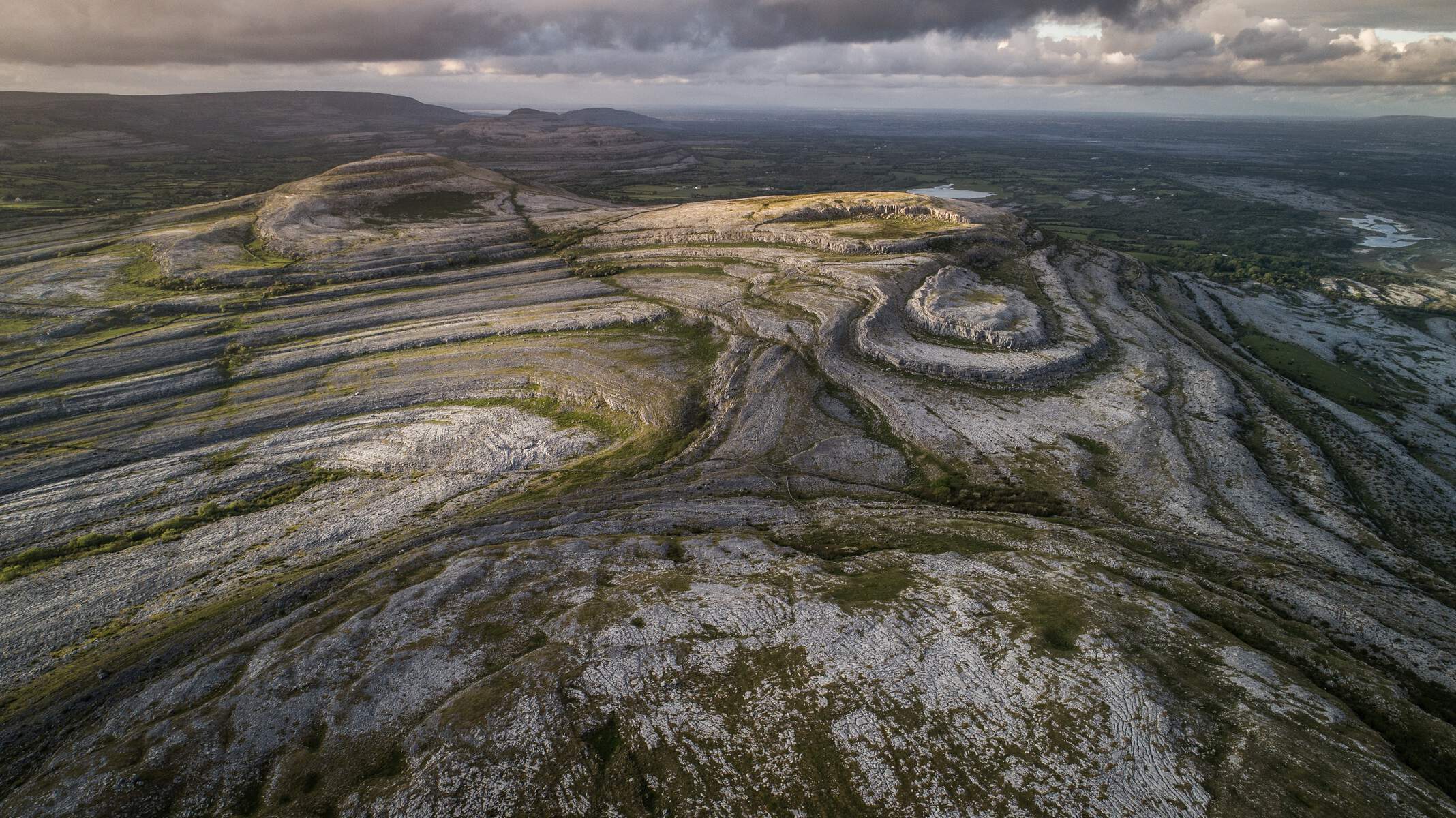
Geology
The Burren is one of the world’s finest examples of a glacio‑karst landscape. Carboniferous limestone, laid down 325 million years ago in a tropical sea, was later stripped by successive glaciations, leaving a network of clints (flat limestone slabs) and grikes (deep fissures). Over 50 km of caves have been mapped, the most accessible being Aillwee and Doolin Cave. The highest point in the national park is Knocknanes Hill at 207 m.
Flora & Fauna
Because the thin soil in the grikes retains moisture, the Burren supports an unusual blend of Arctic‑alpine and Mediterranean plants. Visitors in late May can spot spring gentians, mountain avens and a spectacular array of orchids – 23 of Ireland’s 28 species, including the endemic Dactylorhiza fuchsii subsp. okellyi. The limestone pavement also hosts rare lichens and 24 species of fern.
Animal life is equally diverse: butterflies such as the pearl‑bordered fritillary, the pine‑marten (one of Ireland’s main breeding areas), badgers, foxes, and feral goats roam the uplands. Bird‑watchers can spot peregrine falcons, kestrels and the occasional grey seal along the coast.
Practical Information
Getting There
The Burren is well‑connected by road, rail and bus:
| Mode | Details |
|---|---|
| Car | Accessible via the M18 motorway (Galway – Limerick – Shannon Airport). Electric‑vehicle hire and car‑pooling are encouraged. |
| Bus | Regular Bus Éireann services (route 350) link Galway, Ennis and Limerick with villages such as Lisdoonvarna, Ballyvaughan and Kilfenora. |
| Train | Nearest stations are Ennis and Galway; both have onward bus connections into the Burren. |
| Bike | National cycling routes and quiet “green roads” criss‑cross the landscape – a popular way to explore the Geopark sustainably. |
| Air | Shannon Airport is the closest international gateway (≈ 90 min by car). |
Visitor Facilities
- Burren National Park – free entry; a modest visitor information point sits at Corofin. Parking is available at most trailheads and at the main attractions (e.g., Aillwee Cave, Fanore Beach).
- Cave tours – Aillwee and Doolin Cave charge admission (check each site’s website for current rates).
- Accommodation – A range of B&Bs, guesthouses and self‑catering cottages are scattered across the villages of Doolin, Ballyvaughan, Lisdoonvarna and Corofin.
- Food – The Burren Food Trail links producers such as Burren Gold Cheese, the Burren Smokehouse, and several farm‑to‑table cafés. Many establishments source ingredients from the surrounding farms, offering a true sense of place.
Sustainable Travel
The Burren Ecotourism Network promotes low‑impact visits. Visitors are encouraged to use the free Burren and Cliffs Explorer Shuttle (hop‑on, hop‑off) or rent an e‑bike to reduce car traffic. All attractions participate in the Geopark’s Code of Practice, which includes waste reduction, water‑wise practices and respect for fragile limestone habitats.
When to Visit
Late spring (May‑June) offers the richest floral display, while summer provides longer daylight for the longer walks of the Burren Way. Autumn brings quieter villages and dramatic coastal light; winter is quieter but still accessible for those prepared for cooler, wetter conditions.
A Day in the Burren (Suggested Itinerary)
- Morning – Start at the visitor centre in Corofin, then drive the Burren Scenic Drive (≈ 64 km). Stop at the Fanore Viewpoint for sweeping sea vistas.
- Mid‑day – Explore Poulnabrone Dolmen and the nearby Caherconnell Stone Fort. Grab a lunch of locally sourced cheese and soda bread at a roadside café.
- Afternoon – Descend into Aillwee Cave for a guided tour, then visit the Birds of Prey Centre.
- Evening – Head to Fanore Beach for a sunset walk, or enjoy live traditional music in Doolin before retiring to a cosy B&B.
Further Exploration
Beyond the core sites, the Burren Way offers five‑day trekking options that thread through remote valleys, historic ring forts and the dramatic Cliffs of Moher. Cyclists can follow the Burren Discovery Trail, a 64‑km loop highlighted on the official Geopark map. For families, the Burren Nature Sanctuary in Cloonasee provides gentle nature walks and interactive wildlife displays.
Stay curious, travel lightly, and let the ancient stones and wildflowers of the Burren tell their story.