Overview
The Kerry Way (Irish: Slí Uíbh Ráthaigh) is Ireland’s longest National Waymarked Trail, stretching roughly 215 km (134 mi) around the spectacular Iveragh Peninsula. The route forms a circular loop that starts and finishes in the vibrant town of Killarney, and is traditionally broken into nine stages that can be tackled in 6‑12 days depending on fitness and pace. Waymarking is simple – a yellow arrow on a black background – and the trail is managed by Kerry County Council, the South Kerry Development Partnership and the Kerry Way Committee.
The trail showcases the very best of County Kerry: the shimmering Killarney Lakes, the towering MacGillycuddy’s Reeks (including Ireland’s highest peak, Carrauntoohil), the remote Black Valley, the rugged coastal scenery of Dingle Bay, and a string of colourful villages such as Glenbeigh, Cahersiveen, Waterville, Caherdaniel, Sneem and Kenmare. It is a walkers’ alternative to the world‑famous Ring of Kerry road tour, allowing you to experience the landscape on foot rather than from a car.
History
The concept of the Kerry Way emerged in 1982, when members of the Laune Mountaineering Club and the Kerry association of An Taisce, under the chairmanship of Seán Ó Súilleabháin, began piecing together a network of old roads and paths that criss‑crossed the southwest of Ireland. Inspired by a lecture on historic routes, Ó Súilleabháin recognised a “spider‑web‑like network” that could be linked into a single long‑distance walk. The first section – from Killarney to Glenbeigh – was officially opened by Tánaiste Dick Spring in 1985, making it the second long‑distance trail in the Republic after the Wicklow Way. The full circuit was completed and opened by Minister of State Frank Fahey in 1989. Construction was carried out by workers on FÁS social‑employment schemes, costing £60,000 and resulting in more than 200 stiles, six footbridges, and a full set of way‑markers.
A 2010 review of Ireland’s National Waymarked Trails highlighted the Kerry Way as one of the most heavily used routes and recommended its upgrade to a National Long Distance Trail, a status intended to meet international standards for outstanding trails.
What to See & Do
The Kerry Way is a showcase of Kerry’s natural and cultural highlights. Below are some of the most memorable points along the route:
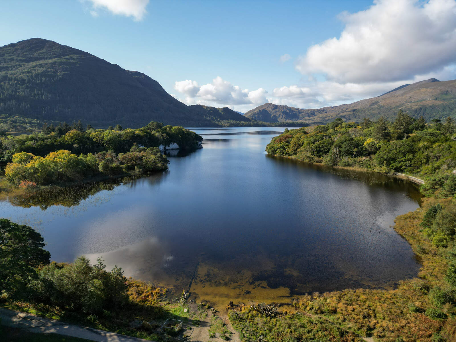
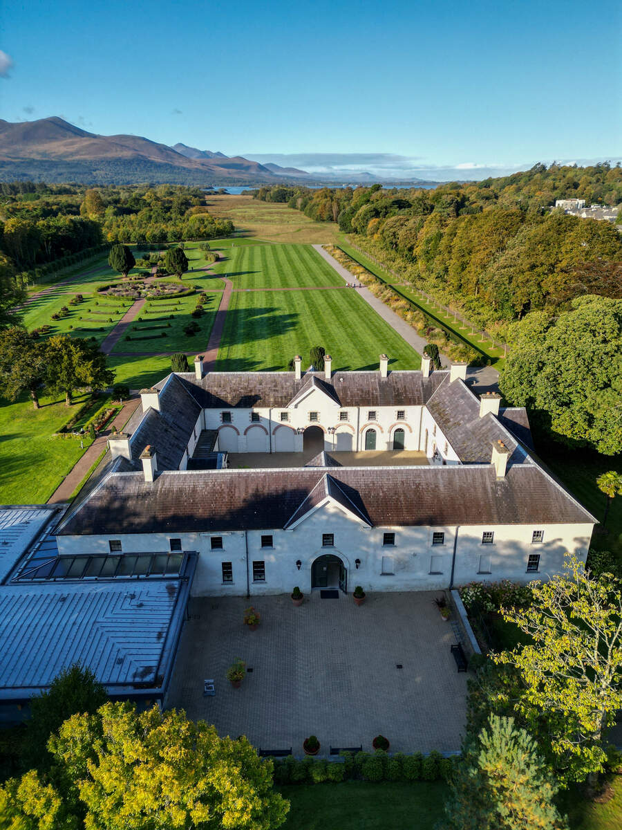
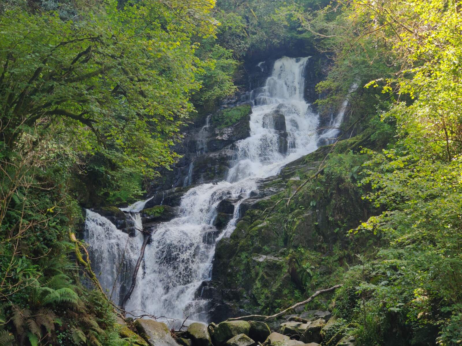
- Killarney National Park – The trail begins in the park’s grounds, passing the historic Muckross House, the tranquil Lough Leane, and the dramatic Muckross Lake before reaching the iconic Torc Waterfall.
- Black Valley – After Torc, the path descends into the secluded Black Valley, a dramatic glen framed by the MacGillycuddy’s Reeks. The valley offers sweeping views of Carrauntoohil and Caher, Ireland’s two highest summits.
- Bridia Valley & Lough Acoose – The route continues through the lush Bridia Valley, skirts Lough Acoose, and follows quiet country roads to the village of Glencar.
- Seefin Mountain – From Glenbeigh, walkers can choose a shorter western loop via Windy Gap or a longer eastern circuit that climbs above Lough Caragh, affording panoramic vistas over Dingle Bay.
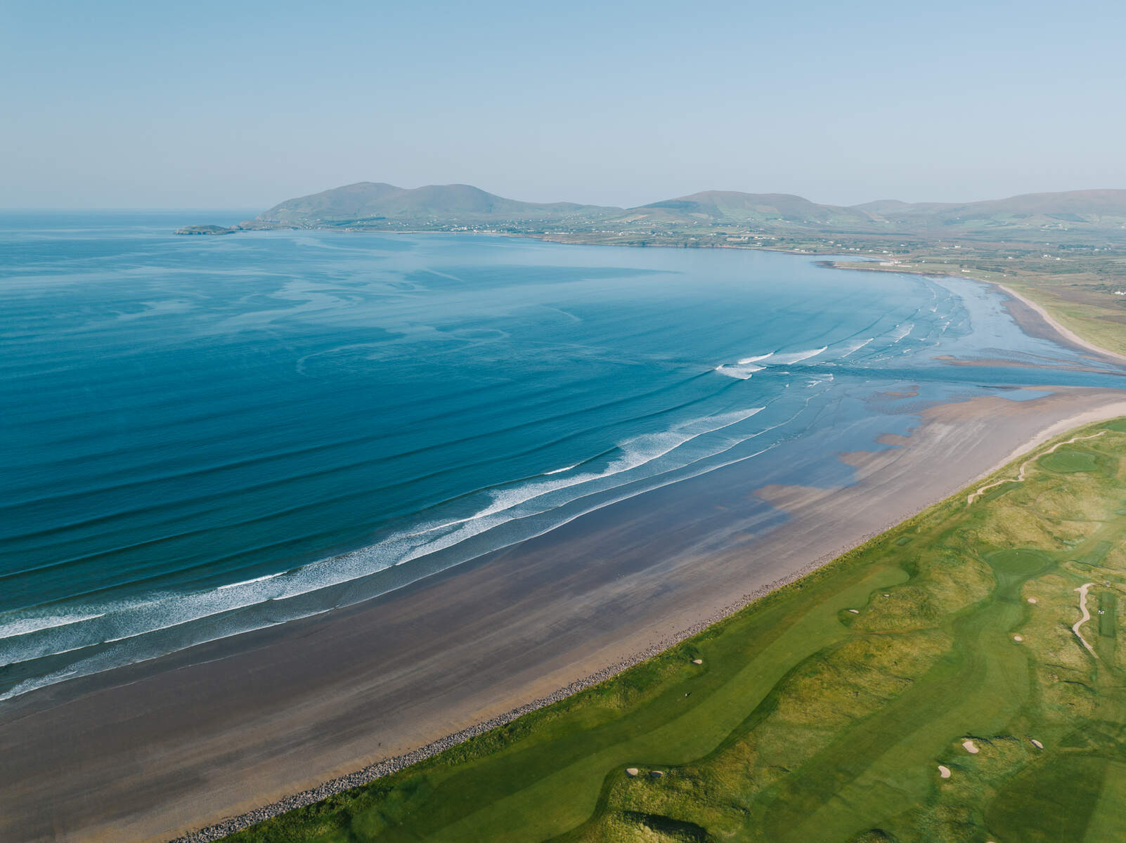
- Coastal Highlights – The trail hugs the Wild Atlantic Way, passing Drung Hill, the Windy Gap (the highest point at 385 m), and offering spectacular sea‑views of Ballinskelligs Bay, the Skellig Islands, and Derrynane Bay.
- Historic Sites – Along the way you’ll encounter ancient stone forts such as Loher Fort (9th century) and Staigue Fort, as well as the 19th‑century Dromore Castle and the 13th‑century Cappanacush Castle.
- Cultural Villages – Each stop – Glenbeigh, Cahersiveen, Waterville, Caherdaniel, Sneem, and Kenmare – offers traditional Irish hospitality, pubs, and local cuisine. Kenmare, for example, is home to the 4,000‑year‑old Reenagoppul Stone Circle.
- Link to the E8 – The Kenmare‑to‑Killarney section forms part of the European long‑distance walking route E8, which stretches from Dursey Island in County Cork to Istanbul in Turkey.
The trail is well‑signposted and can be walked in either direction. Many hikers break the route into the nine official stages, but the trail is also flexible – you can join at any stage, use public transport to move between sections, or even tackle individual day‑walks such as the popular Torc Waterfall to Galways Bridge segment.
Practical Information
The Kerry Way is a strenuous long‑distance walk, with a total ascent of around 5,300 m (Discover Ireland) – roughly the height of climbing Carrauntoohil three times. The highest point on the trail is Windy Gap (385 m) between Foilmore and Caherdaniel. While the overall grade is challenging, the trail includes a mix of moderate, hard, and easy sections, allowing walkers to tailor the experience to their ability.
- Length & Ascent: 215 km; total ascent ≈ 5,300 m.
- Typical Duration: 9‑12 days for the full circuit; many walkers complete it in 7‑10 days.
- Waymarking: Yellow arrow on black background; over 200 stiles and six footbridges.
- Dogs: Not permitted on the Kerry Way (as stated on ActiveME).
- Fees: The trail is free to walk; no admission charges.
- Transport: Killarney is well‑served by bus and rail, and public transport links exist to most towns along the route, making it easy to start or finish at any stage.
- Accommodation: A range of B&Bs, guesthouses and hotels are available in each of the main villages (Killarney, Black Valley, Glencar, Glenbeigh, Cahersiveen, Waterville, Caherdaniel, Sneem, Kenmare). Luggage‑transfer services are offered by many local providers.
- Maps & Navigation: Detailed stage maps are available on the Irish Trails website and via the free ActiveME app (iOS & Android). The official Discover Ireland page also provides an overview and downloadable PDFs.
- Season: The trail is open year‑round. Some high‑altitude sections can be boggy after rain, and the inland stages may be wet and muddy; waterproof boots are advisable.
- Safety: Mobile phone coverage is generally good in towns but can be patchy in remote valleys. Carry a map, compass and a fully charged phone, and let someone know your planned stage.
Below is a quick reference table for the Kerry Way:
| Feature | Details |
|---|---|
| Length | ~215 km (134 mi) |
| Total Ascent | ~5,300 m |
| Typical Stages | 9 (Killarney → Black Valley → Glencar → Glenbeigh → Cahersiveen → Waterville → Caherdaniel → Sneem → Kenmare → Killarney) |
| Difficulty | Strenuous overall; mix of moderate and hard sections |
| Waymark | Yellow arrow on black background |
| Dogs | Not permitted |
| Fee | Free |
| Best Time | Late spring to early autumn for milder weather |
| Transport | Good bus and rail links to Killarney; local services to other villages |
| Maps | Irish Trails website, ActiveME app, Discover Ireland page |
For those who prefer a shorter experience, the trail offers several day‑walk options – for example, the Torc Waterfall to Galways Bridge stretch (≈ 9 km, moderate) or the Coastal Stage 6 from Waterville to Caherdaniel (≈ 13 km, moderate). Whether you aim to complete the full loop or simply sample a few sections, the Kerry Way provides a rewarding blend of mountain grandeur, coastal drama and warm Irish hospitality.
Useful Links
Embark on the Kerry Way and discover why it is celebrated as one of Ireland’s most spectacular and diverse long‑distance walks.