Overview
Lurigethan Mountain (sometimes simply called Lurig) rises to 1,154 ft (352 m) above the village of Cushendall on the north‑eastern edge of the Antrim Plateau. Its flat‑topped summit dominates the skyline, separating Glenariff from Glenballyemon and providing a natural amphitheatre for the surrounding glens. The mountain is part of the basaltic Antrim Hills, a volcanic plateau that stretches from the Giant’s Causeway to Cave Hill near Belfast. From the summit you can see the sea, the Mull of Kintyre in Scotland on a clear day, and the sweeping glens that give the area its name – the “Queen of the Glens”.
History & Legend
The most striking feature on Lurigethan is the prehistoric promontory fort that crowns the plateau. Archaeologists believe the fort was first erected in the Bronze Age (c. 2500‑500 BC) and later re‑used by Iron‑Age Celts. The enclosure once covered roughly 40 acres (16 ha) and would have offered a commanding defensive position with views down both glens and out to the North Channel.
Local folklore ties the mountain to the legendary Fianna warriors. According to tradition, the giant‑hero Finn MacCool and his son Oisín (also known as Ossian) were born on Lurigethan. The fort is said to have been the stronghold of Goll Mac Morna, Finn’s one‑eyed arch‑enemy. A famous clash between the two armies is said to have taken place on the summit, a battle recounted by folklorist Sam Henry as occurring in a hollow called Lagafeenie – “the hollow of the Fianna”.
Place‑names on the mountain preserve these stories: Lig na bhFiann (Hollow of the Fianna) and the nearby hurling club Glenariff Ossians keep the memory of the warrior poet alive. A neolithic court tomb known as Ossian’s Grave lies in the neighbouring townland of Lubatavish, further cementing the mythic landscape.
Folklore & Fairy Tales
The glens surrounding Lurigethan are also famed for their mischievous little people. Local tradition warns against cutting down a “fairy thorn” tree, believing that the fairies will take revenge on anyone who harms it. This superstition is still observed by many farmers in the area, who leave thorn trees standing even in the middle of fields. The mountain itself is said to be a favourite haunt of the fairies, adding an extra layer of mystery to the ancient fort.
Geology & Landscape
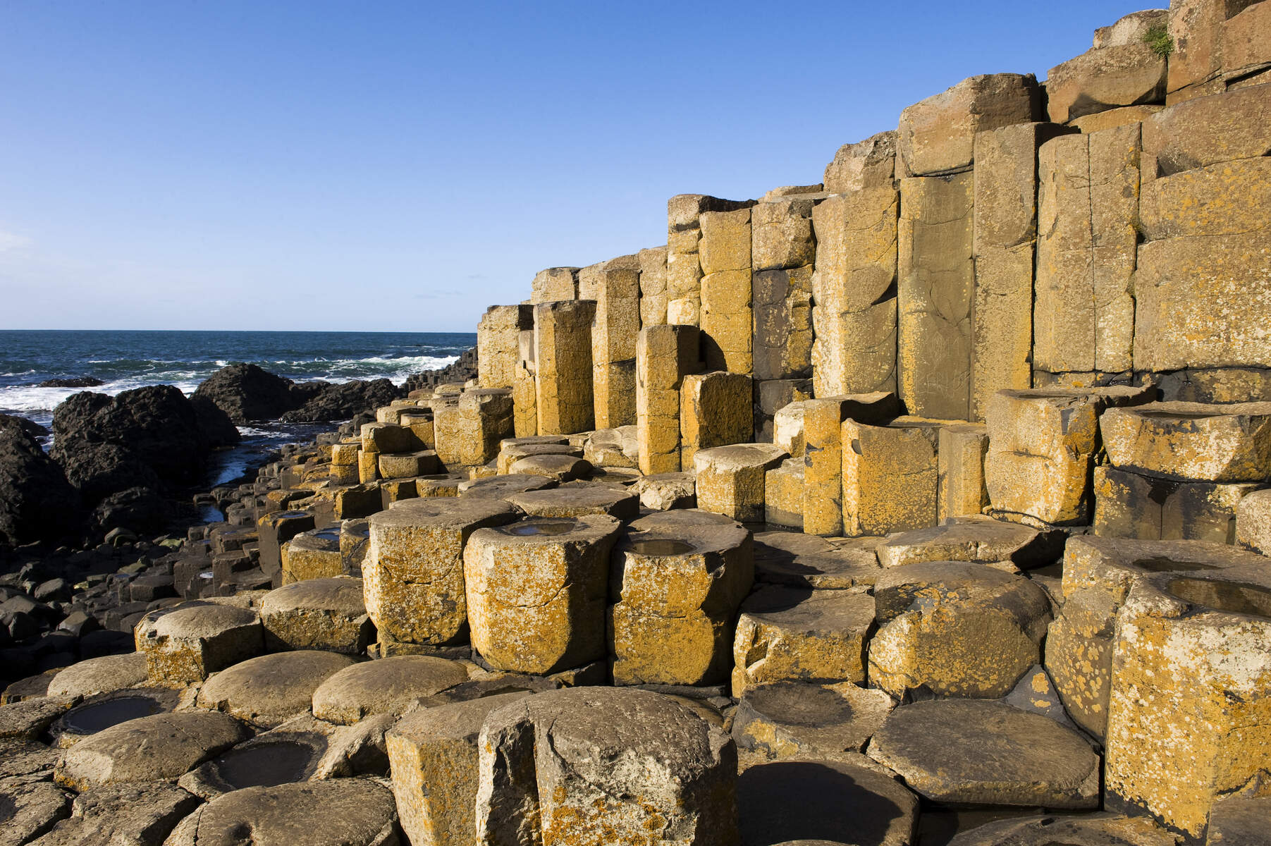
Lurigethan sits on the Antrim volcanic plateau, a landscape formed by basaltic lava flows around 60 million years ago. The southern face displays classic columnar joints that link the mountain visually to the Giant’s Causeway. Walkers can spot these hexagonal columns and see how the ancient eruptions shaped the dramatic cliffs and upland heath that dominate the region.
Guided Walks & Events
The Antrim Rambler runs a guided walk that includes Lurigethan as part of its “Trostan and Lurigethan” circuit (usually held in late May). The walk is suitable for most fitness levels and provides a knowledgeable guide who explains the fort, the geology and the local legends. Booking is available via Eventbrite: https://www.eventbrite.co.uk/o/the-antrim-rambler-69733933323.
What to See & Do
- Promontory Fort – The stone walls are still visible on the plateau. While the interior is overgrown, the earthworks give a tangible sense of the ancient defensive network.
- Panoramic Views – From the summit you can spot the glacial U‑valley of Glenariff, the steep slopes of Glenballyemon, and, on clear days, the Scottish coast across the North Channel.
- Geology Walk – The mountain’s basaltic layers are exposed on the southern face, illustrating the volcanic origins of the Antrim Plateau. Look for the characteristic columnar joints that link Lurigethan to the Giant’s Causeway.
- Ladder‑Farms – On the western slope toward Waterfoot you’ll see the historic “ladder‑farms”, a pattern of stepped fields that allowed early farmers to share the best arable land at the base while using poorer upland for grazing.
- Photography – The mountain provides a dramatic backdrop for shots of Cushendall Beach, the Glenariff Forest Park and the sea beyond. Early morning light often catches the basalt cliffs in a warm glow.
Practical Information
Access – From Cushendall follow the signpost for the Glenballyemon Scenic Route onto the B14 Ballyemon Road. After about 2.5 km you’ll find a small gate on the left (coordinates 55.0669, ‑6.0849) that leads onto the footpath up the mountain. The trail is well‑marked and suitable for most walkers; the ascent takes roughly 45 minutes.
Parking – Free public parking is available on Shore Road opposite Cushendall Beach (see the car park sign). A short, well‑maintained lane leads from the car park to the gate mentioned above.
Facilities – Public toilets are located by the Shore Road car park; they operate seasonally (check the local council website for exact dates). No admission fee is charged for the mountain or the fort.
Coordinates
| Feature | Latitude | Longitude |
|---|---|---|
| Trailhead gate | 55.0669 | -6.0849 |
| Summit (approx.) | 55.0635 | -6.0795 |
Nearby attractions – After descending, you can stroll along Cushendall Beach, visit the Glenariff Forest Park (waterfalls, woodland walks) or explore the historic ruins of Layd Old Church, just under a mile away. The whole area forms part of the Antrim Coast and Glens scenic route.
Seasonal notes – The fort’s stone walls are most visible after a dry spell when vegetation is thin. Winter snow can make the path slippery, so sturdy boots are advisable for those who venture in colder months.
Getting there – Lurigethan is easily reached by car via the A2 Causeway Coastal Route. Public transport options include the Ulsterbus service to Cushendall, with a short walk from the village centre to the trailhead.
Enjoy the blend of natural beauty, ancient history and mythic atmosphere that makes Lurigethan Mountain a memorable landmark on the Antrim Coast.