
Overview
Magilligan Peninsula juts into the mouth of Lough Foyle where the Atlantic meets the lough, forming a dramatic meeting‑point of sea and sky on the north‑west coast of County Londonderry. The foreland is dominated by a 20‑mile stretch of sand dunes – the largest coastal dune system in the British Isles – and a seven‑mile golden strand that links Magilligan Strand to Benone. Designated both a Nature Reserve and a Special Area of Conservation (SAC UK0016613), the area supports priority habitats such as fixed grey dunes, humid dune slacks and shifting white dunes, together with rare plants like pyramidal orchids and creeping willow.
History & Background
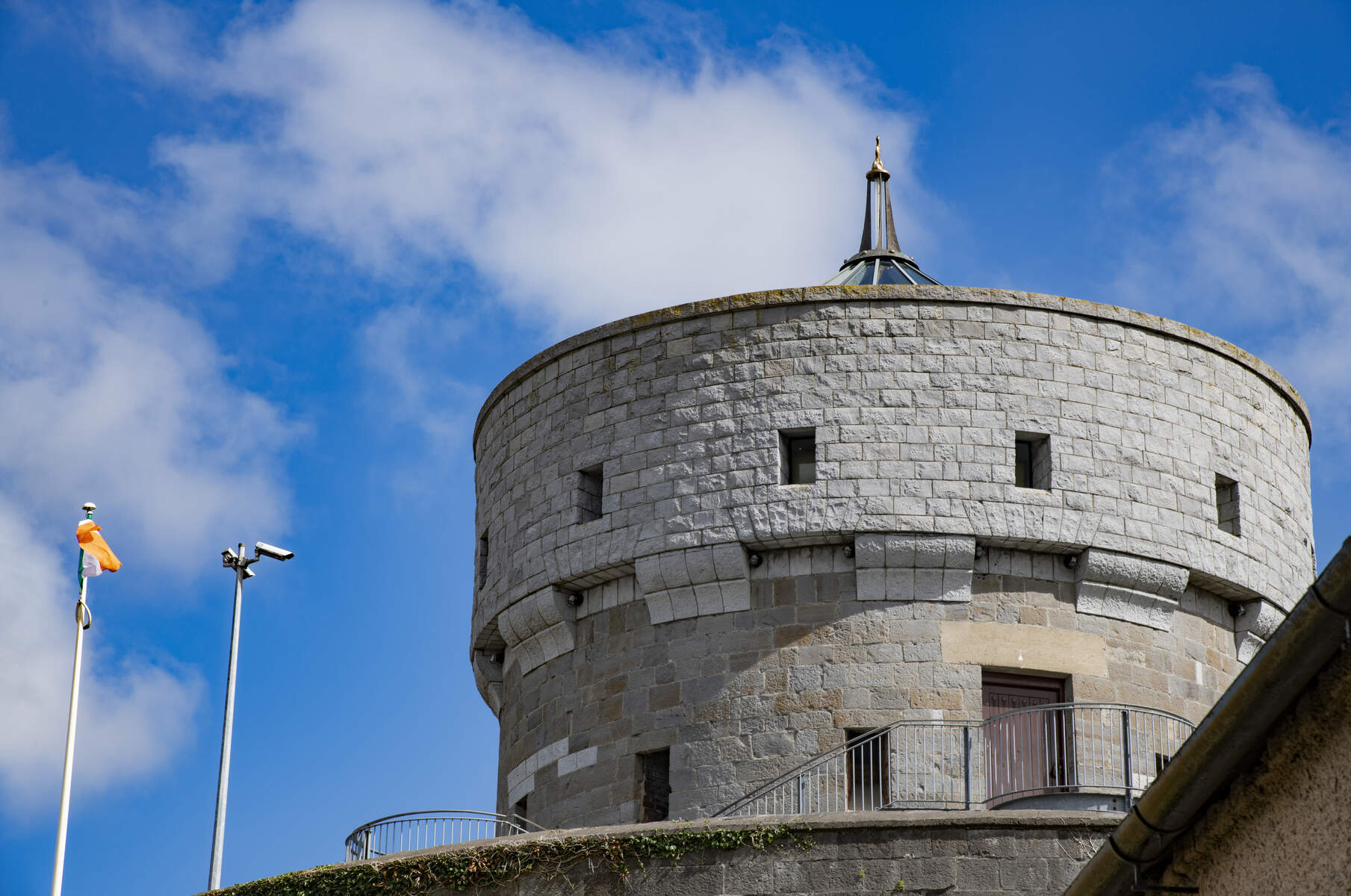
The peninsula’s name derives from the historic district of MacGilligan’s Country in the barony of Keenaght. In the early 19th century the British military erected a Martello Tower on Magilligan Point (construction 1812‑1817). The round stone fort, 10 m high and 12 m in diameter, has walls over 9 ft (≈2.5 m) thick, a retractable wooden ladder entrance and three storeys: a cellar for gunpowder and a freshwater spring, living quarters for an officer and up to twelve men, and a rooftop platform that originally mounted a 24‑pound swivel cannon capable of 360° fire. Though the Napoleonic threat had faded by its completion, the tower remained a key defensive point, later gaining a WWII pillbox on its roof.
Magilligan also played a pivotal role in the Ordnance Survey of Ireland. In 1828 Colonel Thomas Colby selected the flat strand as the baseline for the national triangulation, a project that underpinned the mapping of the whole island by 1846. The site later hosted a small military firing range on the eastern side of the point, and HM Prison Magilligan opened on Point Road in 1972.
What to See & Do
- Walk the dunes: Follow marked trails across the shifting sands, spotting red fescue, lady’s bedstraw, thyme and the occasional pyramidal orchid. The dynamic landscape offers ever‑changing vistas over Lough Foyle and the basalt escarpment of Binevenagh.
- Visit Martello Tower: Climb the three‑storey fort for panoramic views of the lough, the Atlantic and the surrounding dune system. Interpretive panels explain its military past and the engineering feats of the era.
- Birdwatch and wildlife: The SAC’s dune slacks and salt‑marshes attract waders such as Brent geese, curlews and oystercatchers. Early‑morning walks are rewarded with abundant birdlife and the subtle hum of coastal insects.
- Seasonal ferry: In summer a passenger ferry runs across Lough Foyle to Greencastle in County Donegal, offering a quick link to the Republic of Ireland and a scenic alternative to the Causeway Coastal Route.
- Explore the strand: The seven‑mile Magilligan Strand is popular for walking, kite‑surfing and, at low tide, beach‑combing for shells and sea‑glass.
- Water sports: The open Atlantic frontage and steady winds make the peninsula a favoured spot for kite‑surfing and wind‑surfing; local schools offer lessons during the summer months.
- Cycling: The Causeway Coast Way passes through Magilligan, providing a scenic, low‑traffic route for road cyclists and families on the National Cycle Network.
- Fishing: Anglers can try surf‑casting from the strand or cast from the dunes for sea‑bass and mackerel, subject to local regulations.
Nearby Attractions
- Ballymacran Coastal Walk – a gentle coastal path that runs alongside Lough Foyle, ideal for families and dog‑walkers.
- Bird Point – a small headland renowned for its wintering waders and a good spot for spotting ospreys.
- Bann Estuary – a short drive north, offering further bird‑watching opportunities and walking trails.
- Benone Beach and Dunes – just east of Magilligan, with a golf course and additional dune walks.
- Binevenagh – the dramatic basalt mountain provides hiking routes with sweeping views over the peninsula.
Practical Information
- Access: The peninsula is reached via the Causeway Coastal Route (A2) from Limavady, by local bus services, or by the summer ferry from Magilligan to Greencastle. Parking is available at the Magilligan Strand car park; a small fee applies during peak season.
- Facilities: A visitor centre near the dune reserve provides maps, safety advice and information on the firing range schedule (red flags indicate live fire). Restrooms, a café and a small gift shop are located adjacent to the Martello Tower.
- Accommodation: Limited B&Bs and holiday cottages are scattered around the peninsula, most of which operate on a self‑catering basis. Booking ahead in the summer months is advisable.
- Safety: The dunes can be exposed to strong winds; sturdy footwear and sun protection are recommended. When the firing range is active, stay clear of the marked area and obey any flag warnings.
- Opening times: The nature reserve is open year‑round, 24 hours, though the visitor centre operates 9:00‑17:00 (Monday–Saturday). The Martello Tower interior is open during centre hours in summer months; check the visitor centre notice board for seasonal variations.
- Accessibility: Paths around the visitor centre are wheelchair‑friendly, but the dune trails and tower interior involve uneven ground and stairs.
Magilligan Peninsula offers a rare blend of natural dynamism, historic intrigue and coastal recreation – a destination worth bookmarking for anyone exploring the north‑west of Ireland.