Overview
The Morell River (Irish: An Mhoiréil) is a modest yet picturesque tributary of the River Liffey, stretching roughly 16 km from its source at Slieveroe, just west of Blessington Lake, to its confluence near Straffan. Along its north‑south journey the river threads through a patchwork of rural scenery, historic estates, and modern infrastructure, offering a quiet refuge for anglers, walkers and anyone keen to experience a slice of Kildare’s natural heritage.
History & Engineering
The river takes its name from William Morrell, a former landowner whose name first appeared in the 1807 Statistical Survey of the County of Kildare. Over the centuries the Morell has shaped local settlement patterns, feeding the agricultural lands of Naas and supporting the development of nearby racecourses and golf clubs.
Leinster Aqueduct and Water Supply
A notable engineering feature near the river is the Leinster Aqueduct on the Grand Canal. Built in 1780, the stone‑arched aqueduct carries the canal over the River Liffey and incorporates a small pumping station that lifts water from the Liffey to augment the Morell feeder, helping to maintain flow during dry periods. The aqueduct remains a striking example of 18th‑century canal engineering and is visible from the river’s lower banks.
Flood Management
Repeated inundations in townlands such as Killeenmore, Turnings and Sherlockstown have made flood control a priority. The €11 million Morell River Flood Management Scheme, approved by An Bord Pleanála in 2018, aims to protect homes, businesses and agricultural land while preserving the river’s character.
Key components (as of early 2024) include:
- Over 9 km of sloped embankments
- 480 m of flood walls
- Stream realignments and upgrades to up to eleven culverts
- Two stream realignments and a series of culvert upgrades
Recent resident reports (e.g., February 2020 flood at Killeenmore) highlight the scheme’s importance. The project is scheduled for full completion in 2025, though timelines may shift; visitors can view the works from designated public viewpoints at Turnings, Tuckmilltown and Killeen.
Nearby Regeneration: Kerdiffstown Park
Just north of the river, the former illegal waste dump at Kerdiffstown has been remediated and is being transformed into a public park. The site, once a 116‑metre‑high waste mound, now features landscaped green space, walking trails and ongoing environmental monitoring because of its proximity to the River Morell. The park will provide additional recreational opportunities and a new perspective on the river’s floodplain.
What to See & Do
Angling and Wildlife
The Morell’s canopy of maple sycamore (Acer pseudoplatanus) and European alder (Alnus glutinosa) creates a shaded, nutrient‑rich environment ideal for fish. Resident brown trout (Salmo trutta) share the waters with migratory sea trout and Atlantic salmon, making the river a favoured spot for both casual and serious anglers. Anglers should obtain a licence from the Irish Angling website and observe seasonal restrictions.
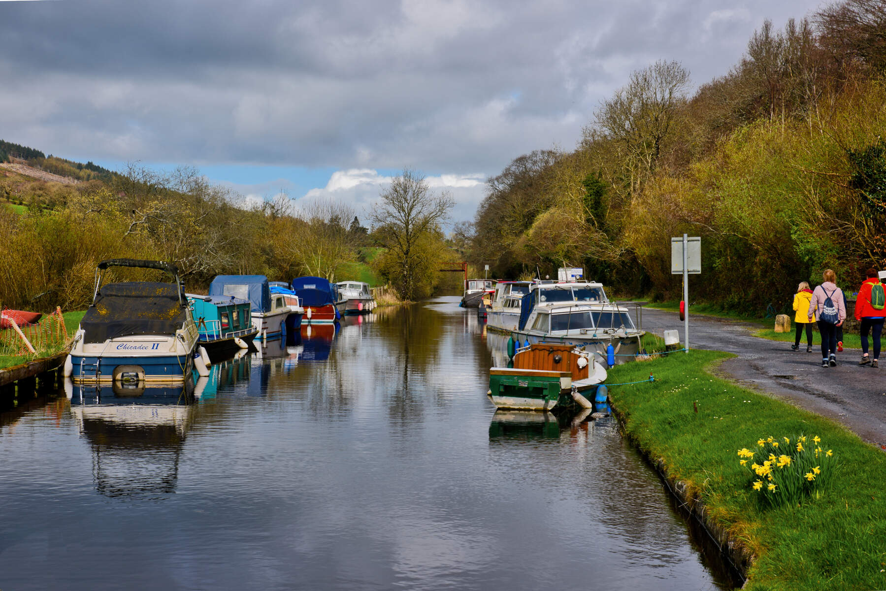
Historic Bridges and the Grand Canal Aqueduct
A short walk north of Naas brings you to the Morell Bridge, where an Environmental Protection Agency monitoring station records water quality. Further downstream the river passes beneath the Grand Canal via the modest Morell Aqueduct – a small under‑bridge that exemplifies 18th‑century canal engineering. The aqueduct sits between the Grand‑Naas Junction and Grand Canal Sea Lock, and while it is un‑rated for mooring, it offers a quiet spot to watch canal traffic glide overhead.
Scenic Walks
The river’s gentle banks are intersected by a network of public footpaths, many of which form part of the broader Kildare tow‑path system. Walkers can trace the river’s course past Punchestown Racecourse, the lush greens of Craddockstown Golf Club and the industrial backdrop of Naas Industrial Estate. The route culminates near Straffan, where the Morell meets the Liffey just a kilometre south of the historic Straffan Weir.
Cycling
The Grand Canal Way runs parallel to the Morell’s lower reaches, offering a low‑traffic, paved surface suitable for cyclists of all abilities. The tow‑path provides easy access to the river’s banks and to the viewing points for the flood‑defence works.
Flood‑Management Exploration
For those interested in contemporary engineering, the ongoing flood‑defence works provide a living laboratory. Construction began in the Turnings area in August 2020 and has since progressed through Tuckmilltown, Ballyhays, Kill and Killeen. By January 2024, 5 250 m of flood defences were complete. Visitors can view the works from designated public viewpoints, gaining insight into how modern infrastructure coexists with historic landscapes.
Practical Information
| Aspect | Details |
|---|---|
| Length | Approximately 16 km (10 mi) |
| River Type | Tributary of the River Liffey |
| Key Access Points | Slieveroe (source), Punchestown Racecourse, Naas Industrial Estate, Straffan (mouth) |
| Fishing | Brown trout, sea trout, Atlantic salmon – licence required via Irish Angling website |
| Parking | Free parking at Punchestown Racecourse car park; limited roadside parking near Turnings and Killeenmore (check signage) |
| Nearby Amenities | Cafés and restrooms in Straffan; public restrooms in Naas; Kerdiffstown Park (future) |
| Accessibility | Lower‑section tow‑path is paved and wheelchair‑friendly; other footpaths are unpaved but generally level |
| Website | https://www.morellfms.ie |
Flood Management Scheme Timeline (selected milestones)
| Year | Milestone |
|---|---|
| 2018 | Planning permission granted by An Bord Pleanála |
| 2020 | Construction commenced in Turnings and Tuckmilltown (summer) |
| 2021 | Works continued through Turnings and Tuckmilltown |
| 2022 | Expansion to Ballyhays, Kill and Killeen |
| 2023 | Completion of works on the Slane River tributary |
| 2024 | Ongoing works in Killeen and Sherlockstown |
| 2025 | Expected full completion (subject to review) |
The scheme is funded by the Office of Public Works and managed by Kildare County Council. Detailed project updates are available on the official site linked above.
Getting There
The River Morell is easily reached by car via the N7 (M7) motorway, which crosses the river just outside Johnstown. Public transport options include regular Iarnród Éireann services to Naas, followed by a short taxi ride to the river’s accessible banks. For cyclists, the Grand Canal Way runs parallel to the Morell’s lower reaches, offering a scenic, low‑traffic route.
Conservation Note
The Morell River Green Belt, legislated in 1975, protects a 44‑km stretch of the river with a 60‑metre riparian buffer on each side. This conservation zone helps maintain water quality, supports wildlife habitats and ensures that future generations can enjoy the river’s natural beauty.
Nearby Attractions
- Figile River – another tributary of the Liffey, popular for angling and walking (Figile River).
- Grand Canal Way – long‑distance walking and cycling route following the historic canal.
- Kerdiffstown Park – upcoming community park on a former waste‑dump site, offering new green space adjacent to the Morell.