
Overview
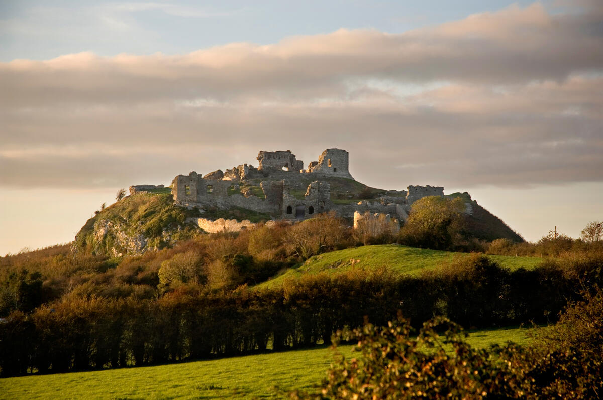
Rising sharply from the flat pastoral expanse of the Midlands, the Rock of Dunamase is one of Ireland’s most dramatic hilltop fortifications. Perched on a limestone crag roughly 45 metres above the surrounding fields, the site sits midway between Portlaoise and Stradbally. Managed by the Office of Public Works as a national monument, the ruins are free to enter and open year-round. The climb up is short but steep, rewarding visitors with 360-degree views across County Laois and the distant peaks of the Slieve Bloom Mountains.
A Layered History
The rock’s strategic position has made it a prize for centuries. The earliest settlement dates to the 9th century, when a drystone dún (fort) was built to guard the area. Historical annals record a fierce Viking raid in AD 845, and archaeological excavations in the 1990s uncovered a silver penny and sections of the original fort walls, confirming the site’s early importance.
The landscape changed forever in the late 12th century. Diarmait Mac Murchada, King of Leinster, granted the rock to his daughter Aoife as part of her dowry when she married the Norman leader Richard de Clare, known as Strongbow, in 1170. Strongbow commissioned the first stone fortifications, transforming the site into a formidable Anglo-Norman stronghold. Through marriage alliances, the castle later passed to William Marshal, Earl of Pembroke, and then to the Mortimer family.
By the 14th century, the native Ó Mórdha (O’Moore) clan had reclaimed the rock, but the castle was already deteriorating. The final military blow came during the Cromwellian campaigns of the 1650s, when the walls were deliberately slighted to render the fortress unusable. In the 1700s, Sir John Parnell attempted to convert the ruins into a Gothic-revival banqueting hall, importing architectural fragments from other Irish sites, but the project was abandoned. The State acquired the monument in 1986, and extensive conservation work has since stabilised the masonry and secured the pathways for visitors.
What to See & Do
Walking the perimeter feels like tracing the outline of a medieval fortress. The approach leads to the impressive twin-towered gatehouse, which still features a murder hole and a slot for a portcullis. Just beyond lies the outer barbican, a deep defensive ditch that once held a wooden palisade. The inner barbican and its steep trenches were designed to funnel attackers into exposed positions, while the lower ward would have housed stables, forges, and barracks.
At the summit, the Great Hall anchors the upper ward. Though roofless, the remaining vaulted arches and thick limestone walls convey the scale of the original structure. This is the best spot to take in the surrounding landscape. On clear days, the view stretches across the rolling plains of Laois to the Curlew Mountains in the west and the Wicklow Mountains to the east.
For a deeper dive into the site’s past, Laois County Council produced a free audio guide available on major podcast platforms. The narration walks you through the Viking raids, the marriage of Aoife and Strongbow, and the castle’s eventual decline. You can find the guide here.
Getting There & Parking
By car – The monument is easily accessible from the N80. A small, free car park is located at the base of the hill on the right-hand side of the road. Spaces fill up quickly on sunny weekends, so arriving early is advisable. From the car park, a clearly marked gravel track leads to the gatehouse. The final approach includes a steep incline and a short flight of stone steps.
Public transport – Regular bus services stop in Portlaoise and Stradbally, both within a 15-minute drive. From these towns, a taxi or local lift is the most practical way to reach the rock, as there are no direct public transit routes to the site.
Practical Information
The Rock of Dunamase is unstaffed and open during daylight hours throughout the year. There is no entry fee.
- Opening hours: Daylight hours only (typically 9 am to sunset). The site closes automatically at dusk, so plan your visit accordingly.
- Admission: Free.
- Accessibility: The main route is well-defined, but the steep gradients, uneven limestone surfaces, and stone steps at the gatehouse mean the site is not suitable for wheelchairs or pushchairs. Visitors with mobility issues should take care on the steeper sections.
- Dogs: Welcome on a short lead. Please carry bags to collect waste.
- What to wear: The limestone surface can be slippery when damp, and the exposed summit gets windy. Sturdy footwear with good grip is essential.
- Navigation: GPS coordinates for the car park are 53.031783, -7.210743. From Dublin, take the M7 to Junction 16, then follow the N80 westbound for approximately 45 minutes.
Nearby Attractions & Trails
The Rock of Dunamase sits in a region dense with heritage and natural beauty. Just a short drive away, Emo Court offers a fascinating glimpse into 18th-century architecture and landscape design. For a change of pace, the Irish National Stud and its adjoining Japanese Gardens provide a peaceful stroll among rare plant collections and thoroughbred horses.
History enthusiasts can visit the Timahoe Round Tower and the 12th-century church nearby, or follow the Laois Heritage Trail, a long-distance walking route that connects dozens of archaeological sites and historic towns across the county. The village of Clonaslee serves as a convenient base for exploring the wider area and is the official gateway to the Slieve Bloom Mountains for longer hikes.
The site is best visited in the late afternoon when the low sun casts long shadows across the ruins, bringing out the texture of the ancient stonework. Arriving before the weekend crowds ensures a quiet moment at the summit, where the only sound is the wind moving across the Laois plains.