Overview
Shelagh’s Head (often written as Slea Head) is the dramatic promontory that marks the western tip of the Dingle Peninsula in County Kerry. Part of the Wild Atlantic Way, the headland juts out into the Atlantic, framing the Blasket Islands and offering some of Ireland’s most striking seascapes. The popular Sleaf Head Drive is a 38 km (24 mi) circular route that begins and ends in the colourful town of Dingle. While the loop can be driven in under an hour, most visitors allocate at least three to five hours to stop at the many viewpoints, historic sites and beaches that line the road.
History & Landscape
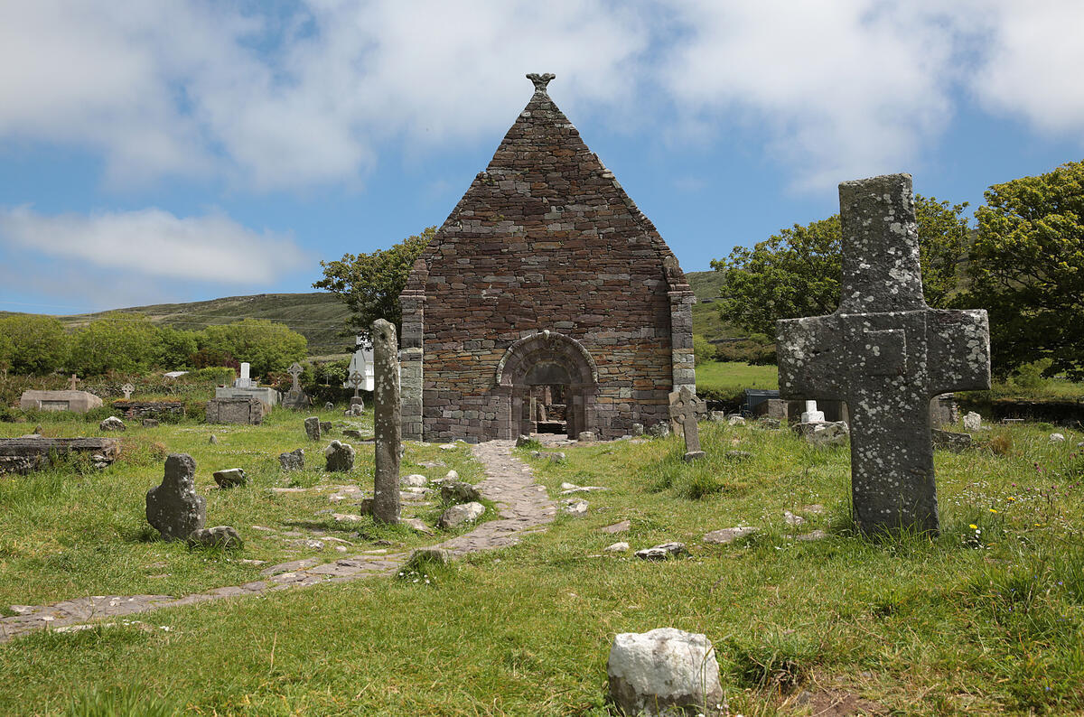
The landscape around Shelagh’s Head has been shaped by millennia of human activity. Early Christian beehive huts, stone oratories and field systems dot the roadside, testifying to a settlement history that stretches back over a thousand years. The nearby Blasket Islands were home to a vibrant Irish‑speaking community until their evacuation in 1953, a story now told at the Blasket Centre in Dun Chaoin. The headland itself has long served as a navigation point for fishermen and sailors, its white‑cross marker becoming an iconic photograph for travellers on the Wild Atlantic Way.
What to See & Do
| Stop | Highlights | Why Visit |
|---|---|---|
| Ventry Beach | 3 km blue‑flag beach, dunes, lake backdrop | Ideal for a short walk, picnics and spotting local wildlife. |
| The White Cross | Striking white crucifix against cliff‑side | Offers one of the clearest views of the Blasket Islands on a clear day. |
| Dunmore Head Viewpoint | Westernmost point of mainland Ireland | Panoramic Atlantic vistas; start point for the Dunmore Head Loop trail. |
| Coumeenoole Beach | Rugged cliffs, filming location for Ryan’s Daughter | Perfect for photography and a brief beach stroll. |
| Dun Chaoin Pier | Launch point for Blasket Island ferries | Dramatic cliff‑top scenery; glimpse the historic pier and grazing sheep. |
| Blasket Centre | Interactive museum on island life | Insight into the culture and hardships of the former Blasket community. |
| Ceann Sibéal Viewpoint | Featured in Star Wars: The Force Awakens | Spectacular sea‑stack scenery; a treat for film fans. |
| Clogher Strand | Circular bay with views of ‘Fear Marbh’ island | Quiet beach walk and a chance to spot the northernmost Blasket island. |
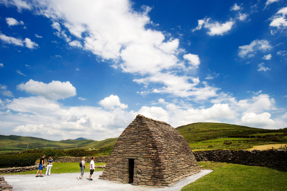
| Gallarus Oratory | 11th‑century dry‑stone church | One of Ireland’s best‑preserved early Christian structures; free entry to the oratory itself. |
Beyond the listed stops, the drive is peppered with unnamed viewpoints that reward a spontaneous pull‑in. The narrow, winding roads wind past ancient beehive huts near Fahan, abandoned farmsteads and open fields where sheep graze against a backdrop of sea‑sprayed cliffs.
Walking & Hiking
The Slea Head Drive forms part of the Kerry Way, a long‑distance walking route that traverses the peninsula. For those who prefer a shorter stroll, the Dunmore Head Loop is a modest trail (approximately 2 km) that starts from the Dunmore Head viewpoint and circles the headland, offering alternative angles on the Atlantic and opportunities to spot seabirds.
A popular extension is the Ceann Sibéal coastal walk, a 3‑km path that links the White Cross to the sea‑stack viewpoint. The route is well‑marked, mostly level and suitable for families, though sections near the cliffs can be uneven.
Wildlife & Photography
The headland’s cliffs host colonies of gannets, razorbills and puffins (the latter most visible in late spring). Dolphins and porpoises are frequently sighted from the road or a quick boat trip from Dun Chaoin Pier. Photographers will find the best light in the early morning or late afternoon when the low sun illuminates the sea stacks and the white‑cross marker.
Seasonal Highlights
- Spring (April‑May) – Wildflowers carpet the dunes at Ventry and Coumeenoole; migratory birds begin to arrive.
- Summer (June‑August) – Long daylight hours allow for extended walks; the Blasket Centre runs special storytelling sessions.
- Autumn (September‑October) – Quieter roads, dramatic Atlantic storms and vivid autumn colours on the cliffs.
- Winter (November‑March) – Powerful wave action creates spectacular sea‑foam displays; be aware of strong winds and slippery paths.
Practical Information
- Route length & timing: The loop is roughly 38 km. Without stops it can be completed in about 55 minutes, but most visitors spend 3–5 hours to explore the key sites.
- Direction: Clockwise travel is strongly recommended. Pull‑in areas are positioned for safer stops and provide better sightlines to the sea and islands.
- Road conditions: The road is narrow in places and shared with local traffic, cyclists and occasional farm animals. Drive slowly, use designated pull‑ins and avoid stopping on blind bends.
- Parking & fees: Parking at most viewpoints (e.g., White Cross, Dunmore Head, Ceann Sibéal) is free and limited to a handful of cars. There is no admission charge for the drive itself; the Blasket Centre charges a modest entry fee for its museum.
- Accessibility: Pull‑in areas are generally level, but the terrain at some viewpoints (e.g., cliffs at Dun Chaoin Pier) involves uneven ground and steep steps, making full wheelchair access limited.
- Getting there: The drive starts at the R559 just outside Dingle town. Fuel up in Dingle and follow the road signs marked “Slí Cheann Sléibhe”. Public transport to the peninsula is limited; a rental car is the most practical option.
- Dog‑friendly: Dogs are welcome on most pull‑ins and walking routes provided they are kept on a leash and owners clean up after them.
- Safety: Stay well back from cliff edges, especially in windy conditions. Tide levels can affect access to Coumeenoole Beach – check local tide tables in summer.
- Best time of day: Early morning or late afternoon provides the most dramatic light on the cliffs and islands. Mid‑day can be busier, especially from June to August.
- Seasonality: Summer (June‑August) offers the longest daylight hours, but shoulder seasons (spring and early autumn) provide quieter roads and vibrant wild‑flower displays.
- Nearby services: Dingle town offers a full range of accommodation, restaurants and fuel stations. Annascaul and Ballydavid also have small shops and cafés. For guided experiences, see the Slea Head Drive Tour offered by Steve’s Peninsula Tours.
- Website: Shelagh’s Head does not have a dedicated official website; the link above is a private tour‑operator page.
Nearby Attractions
- Ballydavid – A Gaeltacht village with a small harbour and access to the Blasket ferries.
- Baile an Fheirtéaraigh – Traditional Irish‑speaking village with craft shops and a coastal walk.
- Annasaul – Picturesque fishing village with a scenic harbour and the Annascaul Lake.
- Brandon Bay – Ideal for wind‑surfing and longer beach walks.
Sample Itinerary (Half‑Day)
- Start in Dingle – Fill up the tank and head west on the R559.
- Ventry Beach – Pull in, stretch your legs and enjoy the sea breeze.
- The White Cross – Snap photos of the crucifix with the Blasket Islands beyond.
- Dunmore Head Viewpoint – Walk the short loop trail for a different perspective.
- Coumeenoole Beach – Quick beach walk; optional coffee at Caife Na Tra (if open).
- Dun Chaoin Pier & Blasket Centre – Explore the museum and watch the ferry depart.
- Ceann Sibéal Viewpoint – Capture the iconic sea‑stack scenery.
- Gallarus Oratory – End the loop with a visit to the ancient stone church before returning to Dingle.
Tags
[“Scenic”,“Historic”,“Free Entry”,“Outdoors”]