
Overview

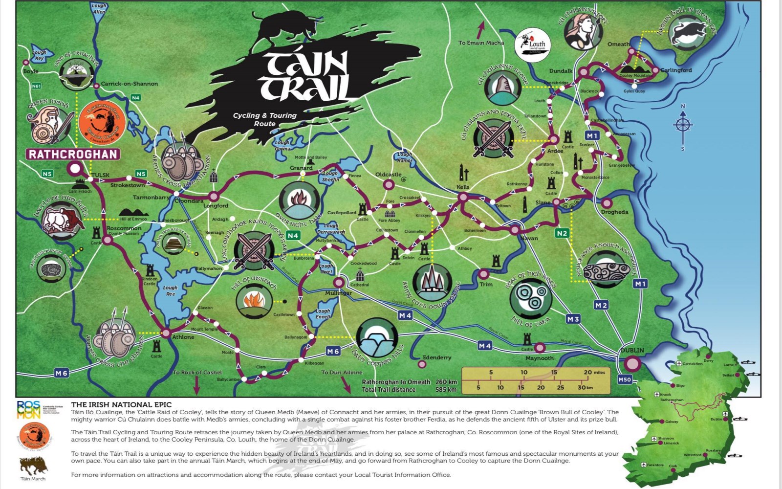
The Táin Trail is a 365-mile (504 km) loop from the royal site of Rathcroghan in Roscommon to the Cooley Peninsula in Louth, tracing the march at the centre of Ireland’s oldest epic. It runs through Roscommon, Longford, Westmeath, Meath and Louth, signed with brown-bull markers that nod to the Táin Bó Cúailnge. You can walk it, cycle it or drive it across the midlands and the Ancient East. Few people do the whole thing; most pick a stretch, and the best of those is around Carlingford.
The story behind it

The trail follows the march of Queen Maeve’s army as told in the 2,000-year-old Táin Bó Cúailnge, the Cattle Raid of Cooley. In the saga Maeve sets out from Rathcroghan to seize the Brown Bull of Cooley, and the boy-hero Cú Chulainn holds off her army almost single-handed. The modern route threads the same line across the midlands, past sites that carry the story:
- Rathcroghan – the royal complex in Roscommon where the army gathered.
- Tarmonbarry – the crossing of the River Shannon, the old Áth Mór.
- Granard – the camp in Longford.
- Kells, Navan and Slane – the Meath sites where Cú Chulainn struck.
- Ardee – the ford on the River Dee where he fought his foster-brother Ferdia, the old Áth Fhirdia.
- Dundalk Bay – the coastal ford into Ulster.
- The Cooley Mountains – where the search for the bull ends.
Medieval castles, early churches and monastic ruins mark the route the whole way along.
Walking, cycling and driving

If you want a real walk, the part to do is the Táin Way, a 40 km National Waymarked route that starts and ends in Carlingford – coastal path, forest track and mountain ridge, topping out at 425 m. Split it into two 20 km stages, or take a shorter segment to suit your legs.
Cyclists can follow the signed road route on the brown-bull markers, with maps posted in the towns. The river-valley gradients suit recreational riders; the coast roads around Carlingford are the popular day-ride. The full trail is also a designated driving route, linking Ardee, Kells and Granard, so you can hop between ruins, craft workshops and villages by car.
The honest caveat: signage has been patchy, which is why Fáilte Ireland has an upgrade project underway. For now, do not rely on the fingerposts alone on the remote sections – carry a map.
Cultural highlights
- Táin March Festival – an annual June festival following the march from Ardee to Carlingford, with walks, reenactments and community events. Details at tainmarch.net.
- Brown Bull sculptures – steel sculptures on the banks of the River Dee at Ardee.
- Cloghafarmore Stone – the standing stone near Knockbridge tied by tradition to Cú Chulainn’s last stand.
Louth highlights
Cooley Mountains
The Cooley Mountains take open cross-country mountain biking, steep climbs and descents on terrain that ranges from short loops to longer rides. Trailheads are signed from Carlingford village.
Ravensdale Forest Park
Ravensdale Forest Park is 8 km north of Dundalk. Three paths meet here – the main Táin Trail, the Ring of Gullion loop and the Ravensdale Loop – and the forest holds standing stones reachable from the loop. There is a small car park at Curralhir Bridge.
Carlingford walks
Carlingford has shorter options through its medieval walls and gates:
- Carlingford Castle Loop – a 3 km path past King John’s Castle and the harbour.
- Omeath Coastal Loop – a 5 km shoreline walk looking across the lough to the Mourne Mountains.
The Carlingford Heritage Centre runs guided heritage walks, open Monday to Friday 10am–5pm and Saturday to Sunday 11am–4pm.
Practical information
The trail sections are free; there are no entry charges on the walking or cycling paths.
Contacts
| Service | Details |
|---|---|
| Tourist Office (County Louth) | +353 42 935 2111 |
| info@dundalktouristoffice.ie | |
| Trail map (PDF) | Download map |
| Táin March Festival | tainmarch.net |
| Carlingford Heritage Centre | +353 429 373 650 – tourism@carlingfordheritagecentre.com |
Transport and parking
Rail stations are at Dundalk and Drogheda, with bus links to Ardee and Carlingford. Navan has no passenger rail and is reached by bus. Parking is available in villages along the route, with designated car parks at Carlingford harbour, Ravensdale Forest Park (Curralhir Bridge) and Ardee town centre.
Accessibility
Paved road sections such as the Carlingford Castle Loop and the town links suit visitors with limited mobility. Forest tracks and mountain trails have uneven surfaces and stiles.
Navigation and seasons
The route is marked by brown-bull fingerposts; for self-guided hiking, use the OSI Discovery Series Sheet 36 and the Táin Way Map Guide. It is open year-round, with autumn and spring giving the best foliage and milder weather. In the uplands the weather turns fast and mobile signal drops out, so carry a physical map and offline GPS routes.