
Most of these roads were not built for the view. The Old Military Road across the Wicklow Mountains went in after the 1798 rebellion so the army could chase rebels off the high bog. The tunnels on the Caha Pass were blasted out in 1842 to move cattle between two valleys. The drives came later, once the traffic that needed them had gone. What you get now is a set of single-lane mountain roads and coast loops where the work is in the driving and the payoff is whatever the weather lets you see that day.
They are ranked here by what you actually see from the road, not by length. If you only have time for one, drive the Conor Pass on a clear day. The order after that is roughly best to least, with one more standout saved for the end.
1. The Conor Pass, Co. Kerry
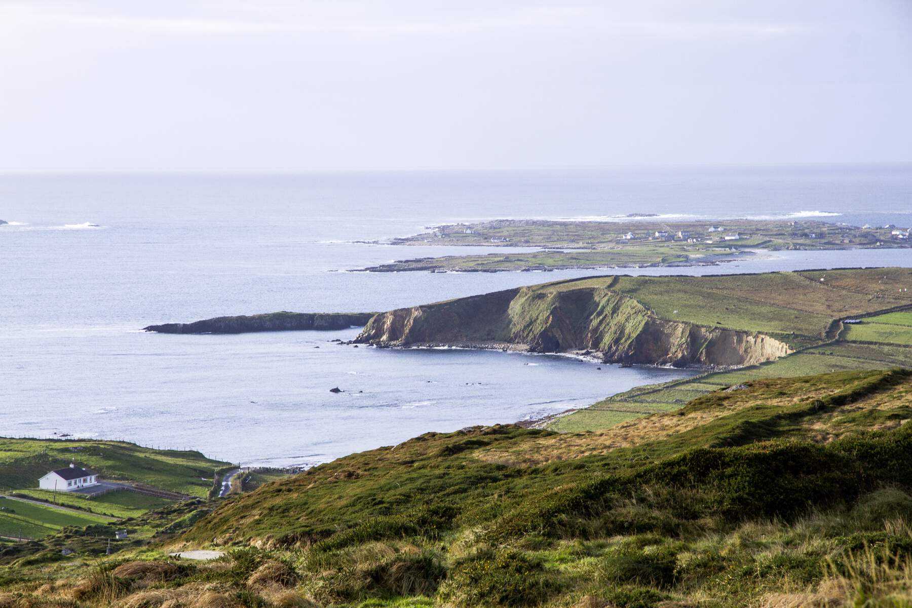
The Conor Pass climbs to 456 m across the spine of the Dingle Peninsula, one of the highest public roads in Ireland and second only, on most reckonings, to Priest’s Leap on the Cork–Kerry border. It runs about 12 km on the R560 between Dingle town and Kilmore Cross, through a glaciated landscape of cliffs, corrie lakes and a wide valley dropping away below. The famous stretch is only about 1.5 km, but it asks for your full attention.

Drive it south to north out of Dingle. Most people find the climb less nerve-wracking than meeting the pass on the descent, when the road narrows against the cliff and the valley falls away on the other side. In places two cars cannot pass, and the etiquette is that one driver reverses to the last wide spot. Vehicles over two tonnes are banned outright, which rules out coaches, camper-vans and caravans – in a bigger vehicle you go round by the coast. From the summit car park the views open south across Dingle Bay to the Skelligs and north to Brandon Bay, with the Aran Islands showing in very clear weather. On the north side, below the road, Lough Doon (Pedlar’s Lake) sits in a corrie above its own small car park, and a thin waterfall drops past it – a trickle in dry weather, a roar after rain.
The honest caveat is the one that decides the day: cloud rolls in fast at this height, and you can climb 456 m only to park inside a cloud with nothing to see. Pick a clear day, or don’t bother.
2. The Sky Road, Co. Galway
The Sky Road is a 16 km loop around the Kingston Peninsula, just west of Clifden, rising to about 120 m on a segment of the Wild Atlantic Way. It splits into two branches. The Upper Road climbs the peninsula’s spine for open views of the Atlantic and the offshore islands of Inishturk and Turbot; the Lower Road stays near the shore and passes the Alcock & Brown crash site.
Drive the loop clockwise. That keeps the best sea views on your left, where the landscape opens gradually rather than dropping away at once. The summit car park, about 5 km out, is the obvious stop, with a viewing platform and room to leave the car. Below it, where the upper and lower roads meet, Eyrephort Beach is a short stretch of white sand for a picnic or a walk. The aviation history is denser than the road lets on: in 1919 Alcock and Brown crash-landed their Vickers Vimy in the Derrygimlagh bog just off the route, finishing the first non-stop transatlantic flight, and Marconi had run a transatlantic wireless station from the same bog since 1905, employing up to 200 locals before it closed in 1922.
The Upper Road is narrow with blind corners and steep drop-offs, and not suited to large coaches or caravans. There is no café, toilet or fuel on the loop, so fill up and stock up in Clifden first.
3. The Caha Pass, Co. Cork & Co. Kerry
Somewhere inside the longest tunnel on the Caha Pass, about 70 metres in, you cross from Cork into Kerry with no sign to mark it. That underground border is the signature of this 27 km stretch of the N71 between Glengarriff and Kenmare, and the reason to take it over any faster route is the run of rough-walled stone tunnels blasted through the ridge.

The tunnels date to 1842, part of a road locally christened ‘The New Line’, blasted out of the rock and finished by hand, which is why the walls are still left rough. The long one, Turners Rock Tunnel, carries the Cork–Kerry boundary, and the summit of the pass at 320 m is inside it. Either side, the views open onto Bantry Bay, the Caha range and glacial lakes like Glanmore. Drive it south to north, from Glengarriff up to Kenmare, and the bay stays in your mirror. Sheep set the pace as much as the bends do, wandering onto the carriageway and resting on the banks. Halfway along, Molly Gallivan’s Cottage and Traditional Farm is the obvious place to break the journey, a roughly 200-year-old cottage kept as it was before electricity.
The tunnels are the catch as well as the draw: narrow and low, with little room for two vehicles abreast, so large coaches struggle with the clearance. Slow right down and check for oncoming traffic before you enter. Reckon about an hour and a half end to end with stops.
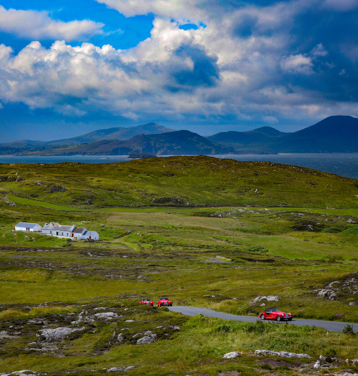
4. The Vee Pass, Co. Tipperary & Co. Waterford
The Vee Pass, known simply as the Vee, climbs to roughly 610 m on the R668 through the Knockmealdown Mountains, linking Clogheen in Tipperary with Lismore in Waterford. It takes its name from the sharp, engineered V-shaped bend near the summit, designed in the 18th and 19th centuries to ease the climb. From the top the land falls away onto the patchwork farms of the Golden Vale, the corrie lake of Bay Lough and, on clear days, the ridgeline of the Galtee Mountains, with Clonmel, Cahir and even the Rock of Cashel in the distance.

Time it for mid-May to mid-June if you can. Rhododendrons, introduced to the slopes in the 1960s to draw visitors, carpet the hillsides magenta and pink at peak flowering, though the exact timing shifts with the weather: a cold, wet spring delays the bloom, and strong winds strip the blossom early. The slopes are worth knowing as well for what they record. A Famine Memorial stands at the summit, marking the route starving families took during the Great Famine of the 1840s, and nearby is the grave of Samuel Grubb, buried upright on a ridge overlooking the valley. The pass formed part of the 1998 Tour de France route, so expect cyclists working the gradients.
Designated parking bays at the summit let you stop without blocking the road. There are no shops or fuel on the pass itself, so stock up in Clogheen, Cahir or Lismore before setting out.
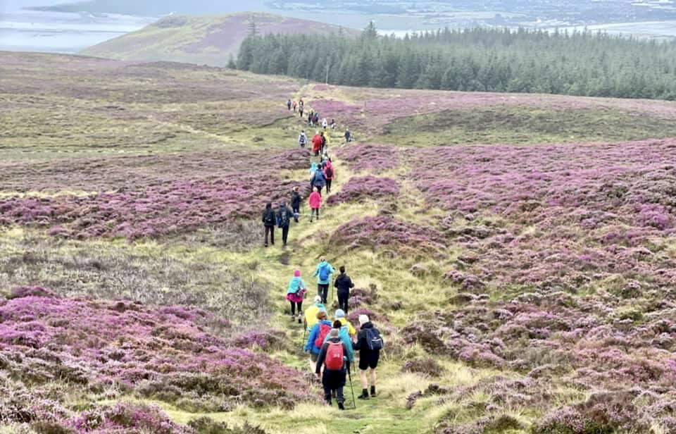
5. The Sally Gap, Co. Wicklow
The Sally Gap crosses the Wicklow Mountains at roughly 500 m, one of Ireland’s highest passes and less than an hour from Dublin. The 26 km drive on the R759 runs through blanket bog and granite, linking Roundwood in the east with the N81 in the west, and takes about an hour without stops. Allow two to three hours to do the viewpoints and short walks properly.

The two stops that matter are Lough Tay and Glenmacnass. Lough Tay is a turquoise lake set between Djouce and Luggala, on private Guinness estate land, so viewing is from the marked path off the R759 and access beyond it crosses private property. Glenmacnass Waterfall is an 80 m cascade with a small car park and a short walk along the verge to the falls. The Old Military Road, cut after the 1798 rebellion, still runs parallel to the route across the plateau, and the open moorland stood in for the Scottish Highlands in the 1995 film Braveheart. Free car parks sit at Lough Tay, Glenmacnass and several pull-ins, but spaces fill quickly on summer weekends.
The winter caveat is real: the road is not routinely gritted and can become impassable after snow or ice, and it lacks guardrails in places. Check the forecast, and if the tops are in fog or the surface is frozen, turn back.
6. The Great Military Road, Co. Wicklow
The Great Military Road is the longer story behind the Sally Gap. The British army built it after 1798 to catch rebels under Captain Michael Dwyer, who were using the hills as cover with no road running north to south across them. So the army cut one: 56 km from Rathfarnham on the southern edge of Dublin over the high bog to Aghavannagh, with the spur most visitors drive today dropping to Laragh and Glendalough. Construction ran from August 1800 to October 1809 under engineer Alexander Taylor.
If you have only an afternoon, drive south from Rathfarnham to the Sally Gap, stop at the Lough Tay viewpoint, then carry on down past Glenmacnass to Laragh. That single run takes in the best of it, and pairs naturally with Glendalough for a day out. Lough Tay is the ‘Guinness Lake’, so named because the dark water above a pale sand beach looks like a pint of plain, and it is the one stop to make if you make only one. Four barracks went up along the route to garrison it; Glencree is now the Glencree Centre for Peace and Reconciliation, beside a quiet German war cemetery for sailors and airmen who died off the Irish coast in the World Wars.
Come early. The Lough Tay pull-in holds only eight to ten cars and fills before 10am on summer weekends, after which you circle back. Morning light suits it anyway, since the road faces the rising sun and the bog colours come alive early.
7. The Cooley Peninsula Scenic Route, Co. Louth
The Cooley Peninsula Scenic Route is an 80 km loop around County Louth’s northeast corner, an hour from both Dublin and Belfast. It threads between Carlingford Lough to the north and Dundalk Bay to the south, under the Cooley Mountains, whose volcanic ridges rise sharply from the farmland to 589 m at Slieve Foy. This is the landscape of the Táin Bó Cúailnge, the Ulster Cycle epic centred on Cú Chulainn.
The walled Norman town of Carlingford is the natural hub, with its original street layout, the ruins of King John’s Castle and free parking a short walk from the harbour. From there the flat 7 km Carlingford Greenway, built on a disused railway line to Omeath, gives lough views across to the Mourne Mountains and is the easy way to see the water without the hills. Older still is the Proleek Dolmen inland, a Neolithic portal tomb from around 3000 BC with a capstone of roughly 40 tonnes; local tradition says a wish comes true if you can land a pebble on the stone and have it stay. The loop drives in around two hours but rewards a full day.
A car is the practical choice, as public transport is limited. Pick up a free scenic-drive map from a local tourist office or guesthouse, and note the Carlingford Lough ferry to Greencastle in County Down runs only seasonally and pauses for maintenance, so check before relying on it.
8. The Mourne Coastal Route, Co. Down
The Mourne Coastal Route follows the A2 for roughly 90 km along County Down’s shoreline, from Strangford Lough to the foothills of the Mournes near Newry. It is clearly signposted in white text on brown panels and is one of Ireland’s more reliable sea-to-mountain drives. Tourism Northern Ireland splits it into three zones, which makes it easy to break into shorter stops rather than commit to the full day.

The pick of the stops sit on the Lecale and Mourne stretches. Castle Ward’s 18th-century stables and gardens were the Winterfell of Game of Thrones, and Europe’s largest sand dune system is at Murlough, where boardwalks cross the dunes on flat, accessible paths. At the western end, Kilkeel is Northern Ireland’s largest fishing port: watch the fleet come in around late morning, then buy langoustines, mussels or king prawns off the harbour. Signposted detours from Newcastle climb into the High Mournes and Whitewater scenic loops for the reservoirs and ridge walks.
One thing to keep straight if you have crossed the border: this is Northern Ireland, so speed limits are posted in mph and prices in pounds, not euro. Parking is free in Newcastle with lay-bys near Annalong, Kilkeel and Warrenpoint. The brown signage is reliable, but an offline map helps with the smaller forest-park entrances and coastal lay-bys.
9. The Inishowen 100, Co. Donegal
The Inishowen 100 is the one to save for last. It is a 100-mile signposted loop around the northernmost peninsula in the Republic, a designated stretch of the Wild Atlantic Way carrying its own spiral logo along the N13 and R238. Free and open year-round, it takes a focused half-day to drive and a full day to do properly.
The route strings together more set-pieces than any other drive here. Grianán of Aileach is a circular stone fort on Greenan Mountain, built around 900 AD by the Northern Uí Néill, with views across Lough Foyle and Lough Swilly. Fort Dunree, built in the early 19th century to guard Lough Swilly in the Napoleonic Wars, holds one of the better collections of coastal artillery in Europe (museum €5 for adults, grounds free). The Mamore Gap tops out at 250 m with a Discovery Point car park for safe photo stops, and the beaches range from Lisfannon near Buncrana to the remote Five Finger Strand, backed by some of Europe’s highest coastal dunes. Kinnagoe Bay is a sheltered cove and the site of a 1588 Spanish Armada wreck.
Fuel up in Buncrana or Carndonagh before you set off, and plan beach stops like Lisfannon and Five Finger Strand around the tide tables, as several are safest at low water. The seasonal Magilligan–Greencastle ferry (April to October) cuts about 30 km off the loop by skipping the inland stretch, but it runs to a fixed timetable and can stop in heavy swell, so check before you count on it.
Practical tips for Irish road trips
- Drive on the left. Many of these routes are single-lane with passing places, and the etiquette is that one driver reverses to the last wide spot. Don’t force a bigger vehicle through.
- Mind the weight limits. The Conor Pass bans vehicles over two tonnes outright, and the Sky Road, Vee and Caha tunnels are no place for coaches or caravans. Take descents in a low gear and slow for blind bends, sheep and cyclists.
- Fuel up and stock up first. There are rarely petrol stations, shops or toilets on the mountain sections. Start with a full tank and carry water and food from the nearest town.
- Watch the weather, not the calendar. Cloud and fog roll in fast above 300 m, and the Sally Gap and Great Military Road aren’t routinely gritted in winter. Check Met Éireann, and if the tops are in fog, the view is the whole point, so save the drive for a clearer day.
- The one fact people forget at the border: the Mourne Coastal Route is in Northern Ireland, where signs read in miles and prices in pounds, while everything south of the border is metric and priced in euro. If a route crosses the line, your speedo and your wallet both need to keep up.
Best single tip: drive the high passes between about 7 and 9am. The light is low across the bog and the bays, the Lough Tay and Sky Road car parks are still empty, and you meet far fewer cars reversing at you on the narrow stretches.


