Overview
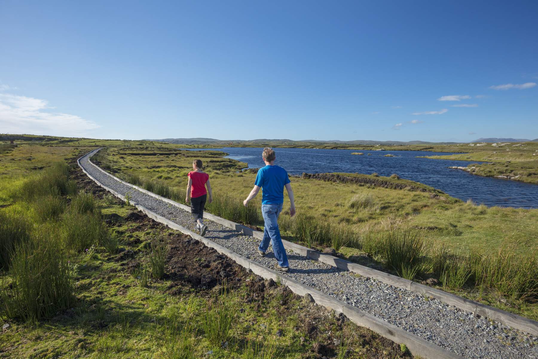
The Marconi Loop Walk is an easy, 4.5 km (approximately 1 hour 45 minutes) circular route that begins and ends at the historic Marconi Station just off the R341 near Clifden. Marked by a distinctive purple arrow on a white background, the trail follows a mix of paved road, gravel tracks and short board‑walk sections that protect sensitive bog habitat. With an ascent of only 30 m, the walk is suitable for most fitness levels and is dog‑friendly provided pets are kept on a lead.
History
In 1905 the Italian inventor Guglielmo Marconi established Ireland’s first commercial wireless radio station at this remote Connemara site, making the western coast a hub of early 20th‑century communications. The station’s legacy was cemented on 18 June 1919 when pilots John Alcock and Arthur Brown, having completed the first non‑stop trans‑Atlantic flight, crash‑landed nearby after a heroic crossing of the Atlantic. Interpretative panels along the route explain both the pioneering radio work and the dramatic landing, giving walkers a tangible sense of the area’s technological heritage.
What to See & Do
- Marconi Station – The trail’s start point is the restored Marconi Station, where information boards detail the original equipment and its role in global communications.
- Alcock & Brown Crash Site – A short detour leads to the spot where the historic aircraft touched down. A modest plaque marks the event, and the surrounding landscape still bears the imprint of the early aviation adventure. See more at the dedicated Alcock & Brown Crash Site page.
- Derrigimlagh Bog – The walk traverses this sensitive bogland, part of the larger Roundstone Bog Special Area of Conservation. Boardwalk sections protect the habitat while allowing close observation of rare flora such as sphagnum mosses and bog cotton.
- Scenic Vistas – From the loop you can glimpse the expansive Roundstone Bog, a series of tranquil lakes, the rugged Twelve Pins mountain range, and the Atlantic coastline. On clear days the sea stretches to the horizon, offering classic Connemara postcard scenery.
- Interpretative Elements – Throughout the route, discreet signs provide insights into the natural heritage – from bird species that frequent the bog to the geological story of the surrounding limestone.
Getting There & Parking
The trailhead is accessed via the R341. A small, free car park is provided at the Marconi Station site; it is a short walk from the parking area to the start of the loop. The nearest towns are Clifden (3.5 km) and Ballyconneely (5.5 km), both offering cafés, public toilets and additional visitor services. There is no regular public transport to the trailhead, so most visitors arrive by car.
Nearby Attractions
- Alcock & Brown Crash Site – Historic aviation landmark a few minutes’ walk from the loop.
- Clifden – A vibrant coastal town with shops, restaurants and the famous Sky Road viewpoint.
- Roundstone Village – A charming fishing village on the edge of the Roundstone Bog SAC, ideal for a post‑walk meal.
Seasonal Tips
The boardwalk sections can become slippery after rain, so sturdy footwear with good grip is recommended. The bog landscape is at its most vivid in late spring and early summer when wildflowers are in bloom. Autumn brings striking colours on the surrounding hills, while winter walks are quieter but may require extra care on wet surfaces.
Practical Information
The Marconi Loop is open year‑round and does not require a booking or an entry fee – it is free to the public. The trail is dog‑friendly but owners must keep dogs on a lead to protect both the wildlife and the delicate boardwalks.
Waymarking – Look for the purple arrow on a white background; it appears at regular intervals and at key decision points.
Map – A downloadable PDF map is provided by Sport Ireland: Marconi Loop Map.pdf.
Contact – For enquiries, the trail is managed by the Derrigimlagh Trail Committee (Tel: 087 996 7351).
Accessibility – The route includes boardwalks and uneven bog surfaces, making it unsuitable for wheelchair users or those requiring a fully paved path.
Navigation – Grid reference L 657 476 (Lat 53.461799, Long ‑10.02497) can be entered into any GPS device for precise location.