Overview
Slighe Mhór (pronounced Slighe Vaw) translates from Irish as “the Great Way”. It is a long‑distance walking route that winds across County Sligo, stitching together the county’s most celebrated landscapes – from the flat‑topped silhouette of Benbulben to the windswept beaches of Mullaghmore and the silent stone circles of Carrowmore. The path is not a single marked trail but a network of public rights‑of‑way, local roads and footpaths that allow visitors to design their own journey while still experiencing the core of Yeats Country.
The route showcases the very elements that make Sligo a magnet for poets, surfers and history buffs: dramatic Atlantic cliffs, ancient burial cairns, tranquil lakes and vibrant towns where music and food thrive. Whether you tackle the whole way over several days or pick a single section for a day‑long hike, Slighe Mhór offers a deep‑dive into the cultural and natural fabric of north‑west Ireland.
History
The name Slighe Mhór harks back to the early medieval road system that linked monastic settlements, market towns and coastal ports across the province of Connacht. These ancient pathways were used by pilgrims travelling to holy sites such as Drumcliff Monastic Site (founded by Saint Colmcille in 561 AD) and by traders moving salt, wool and fish between inland villages and the Atlantic harbours.
Over the centuries the route absorbed layers of history: Neolithic tombs at Carrowkeel and Carrowmore, the 13th‑century Dominican Sligo Abbey, and the 14th‑century Ballymote Castle all sit within a few kilometres of the historic way. In the 20th century the poet W.B. Yeats celebrated the same landscape in verse, cementing Sligo’s reputation as a place where myth and memory walk side by side.
What to See & Do
| Section | Highlights | Approx. Distance |
|---|---|---|
| Benbulben Loop | Benbulben mountain, forest walk, panoramic views of the Atlantic | 5 km |
| Megalithic Heartland | Carrowmore Megalithic Cemetery, Carrowkeel Stone Age burial site, Deer Park Court Cairn | 12 km |
| Coastal Stretch | Mullaghmore Head, Classiebawn Castle, Strandhill surf village, Coney Island causeway | 20 km |
| Lake & Literary Trail | Lough Gill, Innisfree Island, Drumcliff Church (Yeats’ grave), Parke’s Castle | 8 km |
| Knocknarea & Queen Maeve | Knocknarea mountain, Maeve’s Cairn, views over Sligo Bay | 6 km |
Benbulben and the Forest Walk
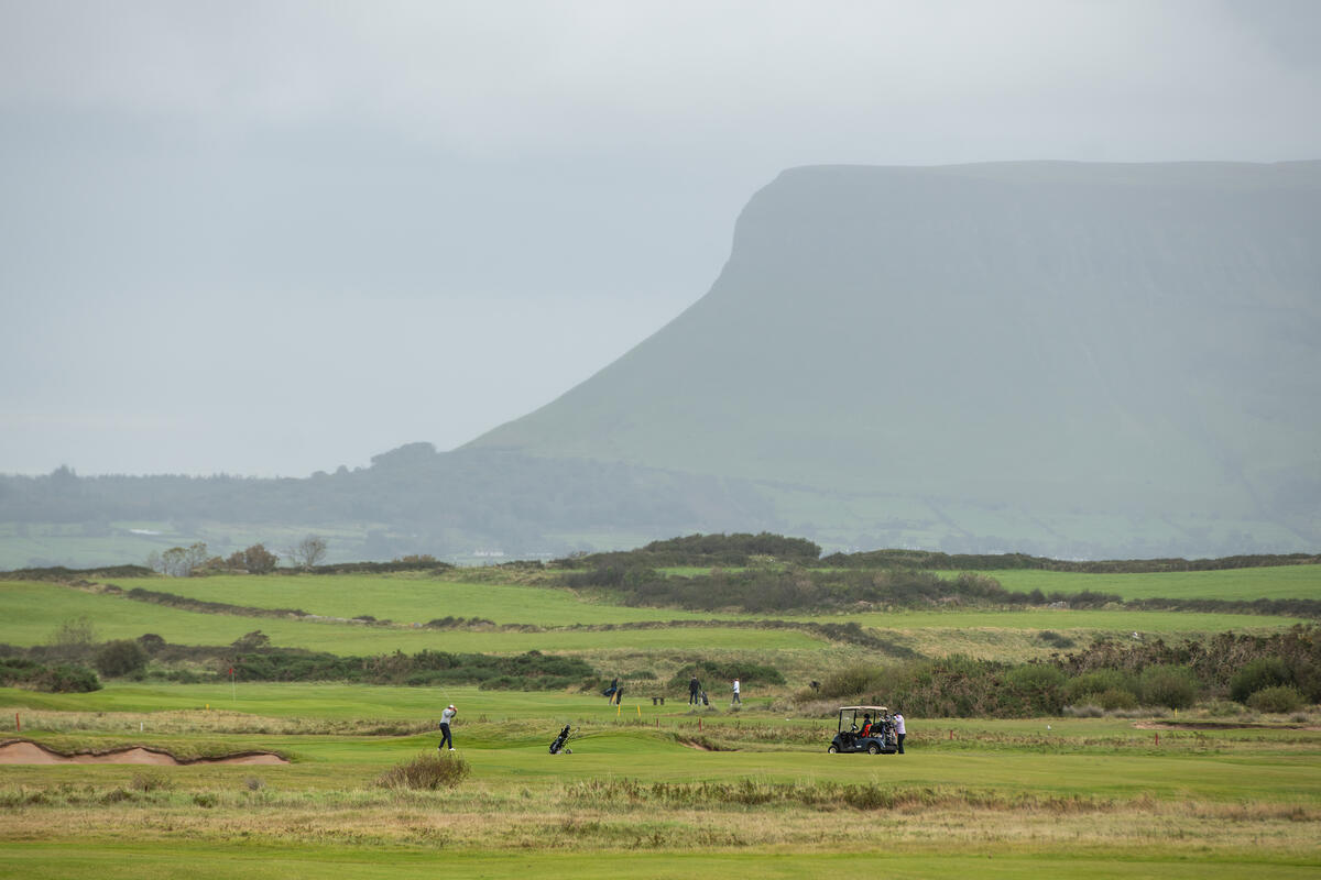
Benbulben dominates the western skyline and is often called “Ireland’s Table Mountain”. A gentle forest trail at its base provides an accessible 1.25‑hour walk that rewards hikers with sweeping vistas of the surrounding countryside and the distant Atlantic. For the more adventurous, the summit trail climbs to the flat top (526 m) and offers a dramatic perspective on the whole of Sligo.
A short detour from the loop leads to Ballymote, where the 13th‑century Ballymote Castle stands on a hill overlooking the surrounding plains – a worthwhile stop for a quick historic glimpse.
Megalithic Heartland
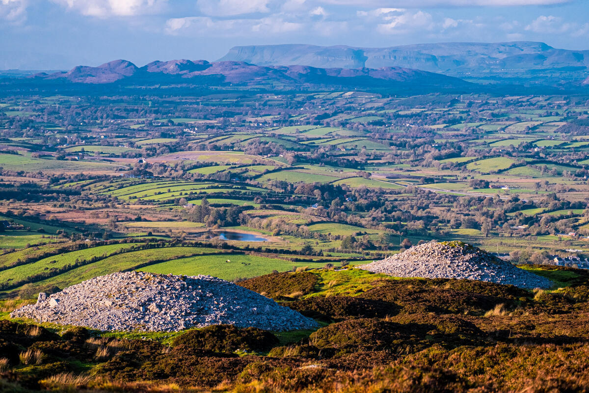
The ancient burial grounds of Carrowmore and Carrowkeel are among the largest Neolithic sites in Europe. Carrowmore contains over 45 stone circles, passage graves and standing stones, some dating back 7,000 years. Carrowkeel’s fourteen cairns and dolmens are set on the Bricklieve Mountains, and one of its chambers is illuminated by the midsummer sun. Both sites are open year‑round; visitors are asked to respect the stones and refrain from climbing on them.
A walk through the nearby Hazelwood Forest offers a peaceful woodland contrast and occasional views of Lough Gill.
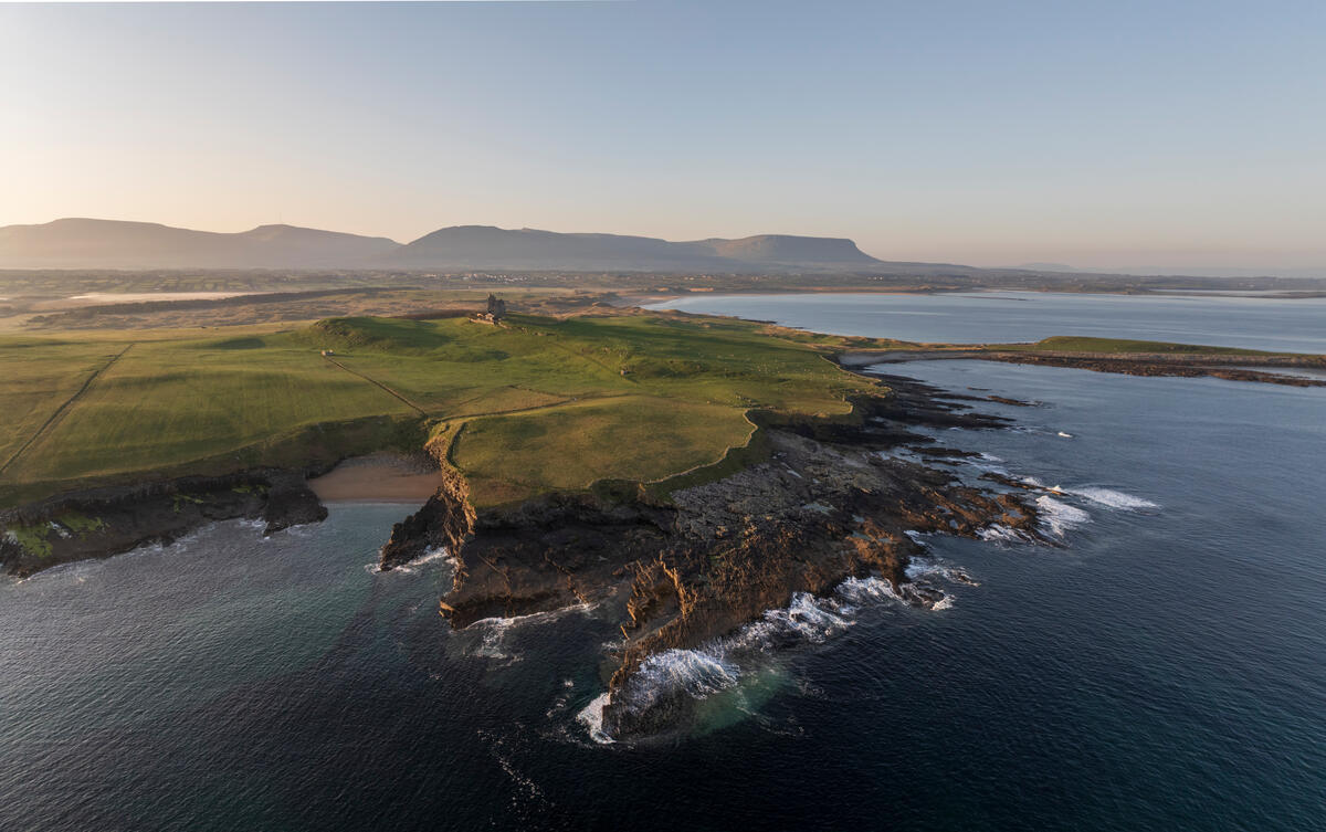
Coastal Stretch
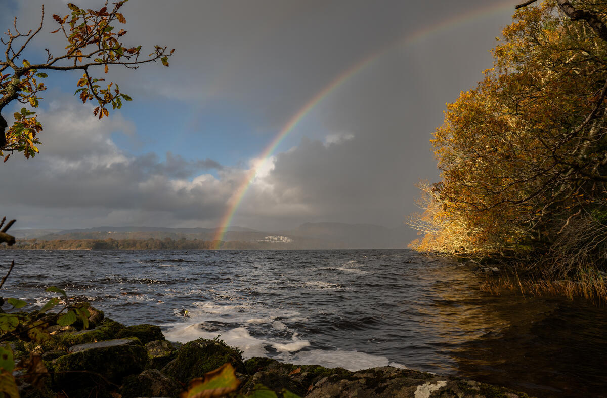
The Atlantic coastline offers a dramatic contrast to the inland hills. Mullaghmore Head is famed for world‑class big‑wave surfing, with waves that can reach 30 ft. Even if you stay on shore, the cliffs provide spectacular photo opportunities, especially with Classiebawn Castle perched on the edge. A short drive east brings you to Strandhill, a lively surf village where surf schools welcome beginners. At low tide, a 5 km causeway from Rosses Point allows a walk to Coney Island, a sandy haven dotted with rabbit‑filled fields.
Lake & Literary Trail
Lough Gill, immortalised by Yeats in The Stolen Child, is a tranquil lake surrounded by woodlands. Boat trips depart from Doorley Park and Parke’s Castle, offering views of the lake’s islands, including the poetic Innisfree.

A short walk leads to Drumcliff Church, where Yeats is buried beneath the shadow of Benbulben – a pilgrimage spot for literature lovers.
Knocknarea & Queen Maeve
The summit of Knocknarea is crowned by a massive cairn traditionally identified as the burial place of the legendary Queen Maeve of Connacht. The hike is moderate and takes about 1.5–2 hours round‑trip, delivering sweeping views across Sligo Bay and the surrounding countryside. Many walkers pause at the cairn to place a stone for good luck before descending.
Nearby Attractions & Side Trips
If you have extra time, consider these short detours that complement the Slighe Mhór experience:
- Ballymote – Explore the medieval Ballymote Castle and its surrounding town centre. (/ballymote/)
- Bunduff Strand – A Blue Flag beach ideal for a seaside break. (/bunduff-strand/)
- Culleenamore Strand – A tidal beach popular with surfers and walkers. (/culleenamore-strand/)
- Ballygilgan Nature Reserve – A haven for birdwatchers and wet‑land lovers. (/ballygilgan-nature-reserve/)
- Lissadell House – Visit the historic house and gardens, especially in the summer months. (/lissadell-house/)
Practical Information
Getting There
County Sligo is well‑connected by air, road and rail. The nearest airport is Ireland West Airport (formerly Knock Airport), with regular flights from Dublin, London and other UK cities. From Dublin or Belfast you can also drive the scenic cross‑country route (approximately 3 hours from Dublin). Bus and train services link Sligo town with major urban centres, and ferries operate from Dublin and Belfast to the nearby ports of Rosses Point.
| Mode | Details |
|---|---|
| Air | Ireland West Airport – flights from Dublin, London, Manchester |
| Train | Irish Rail services from Dublin Connolly to Sligo (approx. 3 h) |
| Bus | Bus Éireann routes from Dublin, Galway and Belfast |
| Car | A‑4 and N4 provide direct road access; a car is useful for exploring remote trailheads |
Accommodation & Food
Sligo offers a range of lodging, from boutique B&Bs in the countryside to hotels in Sligo town. The Sligo Food Trail highlights local producers, fresh Atlantic seafood and artisan cheeses. Popular stops include Hooked (seafood) and Coach Lane (award‑winning wines). Many accommodations provide parking free of charge, and several farm‑stay options sit directly on the route, allowing walkers to break their journey without back‑tracking.
Accessibility
Most of the forest walk around Benbulben is suitable for walkers of moderate fitness, though the summit trail involves steep sections and uneven ground. The coastal paths at Mullaghmore and Strandhill are paved in places and wheelchair‑friendly up to the beach access points, but the tide‑dependent causeway to Coney Island is not suitable for wheelchairs. The megalithic sites are open fields with uneven terrain; sturdy shoes are recommended.
Seasonal Considerations
The route is usable year‑round, but the best weather for long hikes is typically from May to September, when daylight hours are longest and the Atlantic is calmer. Summer months also see the most frequent ferry services to Coney Island and the highest number of guided tours at historic sites such as Lissadell House (open June‑September).
Suggested Itinerary (3‑Day Sample)
Day 1 – Benbulben & Forest Loop – Start in Drumcliff, walk the Benbulben Loop, finish with a sunset view over the mountain. Day 2 – Megalithic Heartland – Visit Carrowmore Cemetery in the morning, then drive to Carrowkeel for an afternoon among the dolmens. Day 3 – Coastal Stretch – Head to Mullaghmore for big‑wave watching, continue to Strandhill for a surf lesson, and end with a walk across the Rosses Point causeway to Coney Island at low tide.
All distances are short enough to be broken into half‑day segments, allowing flexibility for weather or personal pace.
Booking & Fees
Most of the natural attractions (Benbulben, beaches, megalithic sites) are free to access. Guided tours at Lissadell House, Parke’s Castle and the Yeats Society require a modest fee (typically €5‑€10 per adult). Parking is generally free at trailheads, though some coastal car parks charge a small daily rate during the peak summer season.
Contact & Further Information
For up‑to‑date trail conditions, maps and local events, the Sligo County Council tourism office can be reached at 071 9111 111 (Monday‑Friday, 9:00 am‑5:00 pm). Their website provides downloadable PDFs of the Slighe Mhór route and links to local guide services.
Slighe Mhór is more than a walk; it is a living corridor that threads together the myths, mountains and maritime spirit of County Sligo. Follow the Great Way and let the landscape write its own story beneath your feet.